History
Kiwanis Trail was built in a day by the Phoenix Kiwanis Club on April 14th, 1925. Roughly 70 men created the trail in five and a half hours. Including an elaborate lunch from olives to Budweiser followed by ice cream and cigars!
Overview
Kiwanis Trail is an ideal hike to take children on as the distance is short and the elevation gain is not extreme. Avid hikers have opportunities to embark on longer hikes into South Mountain.
Hike
This short hike is a gem for someone who wants to hike during the summer heat but does not want to drive to higher elevation destinations. Sunrise or an hour before sunset offers shade almost the entire route. It winds through a small but pretty canyon to Telegraph Pass. The first half mile is flat, only gaining 160 feet. The hike is most enjoyable after a quarter-mile, signs of overuse begin to fade.
Keep an eye out for three old dams ( 0.2 mi / 0.3 mi / 0.6 mi ) constructed by the Civilian Conservation Corps (CCC) in the 1930s.
During the hike one will often be able to see TV towers atop Mount Suppoa to the left, which is the high point of South Mountain. Read about it's historically famous Colossal Cliffs in the Telegraph Pass guide.
About halfway, the trail gets a bit steeper. It is nothing to fear, only about as steep as going up a set of stairs. Keep an eye out for Native American petroglyphs towards the end of the trail. You will see and hear the sounds of Summit Road as you ascend to the top of the trail, which ends at that road. The final tight switchbacks are steep but over quick and worth the effort.
If this is your first visit, be sure to look over the other side of the road where Ahwatukee and the Gila River Valley spread out. The Rock House built of granite rubble is a good destination with nice views, adds 0.75mi / 180 aeg. It was built of granite rubble by the Civilian Conservation Corps (CCC) ~1933-37. The project was terminated before it and others could be completed.
It is common to see a few hikers on this trail. The lack of parking keeps the crowd count low on lovely days. You will likely see hikers at Summit Road from the Telegraph Trail. It is about 5-10 times more popular, originating in a dense middle upper-class neighborhood.
Alternate access one-way figures
- 0.6mi road walk from 3 Tables
- 0.8mi road walk from 5 Tables
- 1.05mi via Ranger & Los Lomitas
Park Reports
Park manager reports suggest the park turned into an intimate hangout during World War II.
November 5th, 1945 - Once again, Kiwanis Trail comes into the headlines at 8 AM this morning, found Ford sedan parked at the extreme end of Kiwanis Trail, license No. A9541, with GI and girl in rear seat, half-dressed, in a rather embarrassing position... Handled the situation as diplomatically as possible and cleared them out of the park immediately.
January 1st, 1947 - At 2:30 am this morning, we came upon a couple near the end of Kiwanis Trail. This couple... had evidently misinterpreted the true meaning of "picnic area," so we're very much surprised to find that we objected to their kind of "picnic."
When hiking several trails on a single "hike", log it with a generic name that describes the hike. Then link the trails traveled, check out the example.
WARNING! Hiking and outdoor related sports can be dangerous. Be responsible and prepare for the trip. Study the area you are entering and plan accordingly. Dress for the current and unexpected weather changes. Take plenty of water. Never go alone. Make an itinerary with your plan(s), route(s), destination(s) and expected return time. Give your itinerary to trusted family and/or friends.
Permit $$
None
Directions
Road
Paved - Car Okay
To hike From Phoenix, head straight down Central, keep going and going until it hits South Mountain. The road curves west, passing an entrance gate. Keep going to the information/bathroom center. Continue west a tenth of a mile to the second left. Skip the first left for authorized personnel. The second left takes you to Kiwanis. Small sign(s) direct you. From the turn, it is 0.7 mi to the trailhead. Alternative access points are in the description.
page created by HAZ_Hikebot on May 26 2015 10:00 pm
 Route Editor

 History
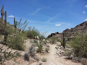


