 Route Editor

| Guide | ♦ | 45 Triplogs | 0 Topics |
details | drive | no permit | forecast | 🔥 route |
stats |
photos | triplogs | topics | location |
| 365 | 45 | 0 |
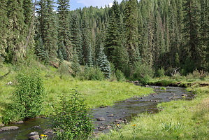
Riverside jewel by desertgirl  West Fork Trail #628 is a short and mostly easy trail that leads you to a picturesque grassy meadow on the West Fork of the Black River. West Fork Trail #628 is a short and mostly easy trail that leads you to a picturesque grassy meadow on the West Fork of the Black River.The trail heads out at an easy grade from the developed trailhead through mixed forests of pine, spruce, fir, and stands of aspen. About 3/4 mile from the trailhead, you run into the 1st of 2 meadows - Neck Tank. The meadow had quite a bit of flowers (iris) blooming, and the dog had a blast chasing large yellow butterflies. The green meadow, flowers, buzzing bees, fluttering butterflies, dappling warm sunshine, and the dense forest beyond presented quite a sight. The trail continues and encounters another meadow. This is a smaller meadow and had a similar ambiance as the earlier meadow. Done with chasing butterflies, we continued, and at about the 2-mile mark, the trail reached the edge of the canyon, the west fork of Black River... vistas opened up to dense slopes of coniferous trees that descended sharply to the river. You proceed along the rim for a bit, taking in expansive views. After the 2.5-mile mark, the trail descends gently. You cross a wooden footbridge across a scree slope. It becomes steeper and rockier as it progresses down the slope; switchbacks at a reasonable grade quickly take you down to the river and a welcome swathe of greenery. The river is relatively narrow, and you find quite a few boulder-hop paths across. This a welcome break from this hike down, and there are many points along this river for a quick break. At many locations, you see the work of the industrious beaver as water spills over their dams. Greenery glittering under the crystal clear water, the babbling brooks and darting fish, trees like willow & alder add to the beauty of this shimmering green riverside community. This is in stark contrast to the surrounding mountainside environment.
Note: You can access this trail from Indian Springs Trail #627.
Check out the Official Route and Triplogs. Leave No Trace and +Add a Triplog after your hike to support this local community. One-Way Notice This hike is listed as One-Way. When hiking several trails on a single "hike", log it with a generic name that describes the hike. Then link the trails traveled, check out the example. | |||||||||||||||||||||||||||||||||||||||||||||||||||||||||||||||||||||||||||||||||||||||||||||||||||||||||||||||||||||||||||||||||||||||||||||||||||||||||||||||||||||||||||||||||||||||||||


