 Route Editor

| Guide | ♦ | 31 Triplogs | 1 Topic |
details | drive | permit | forecast | 🔥 route |
stats |
photos | triplogs | topic | location |
| 185 | 31 | 1 |
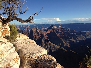
Easy, Scenic Hike by Glitter  This is a short trail out to one of the more interesting views on the North Rim of the Grand Canyon. After taking a 20+ mile drive across the heavily forested Walhalla Plateau, the trail begins a couple of miles short of the Cape Royal Point parking lot. The hike starts with a mild ascent through a quiet forest filled with Ponderosa Pine and Quaking Aspen, as well as some young Gambel Oak. This is a short trail out to one of the more interesting views on the North Rim of the Grand Canyon. After taking a 20+ mile drive across the heavily forested Walhalla Plateau, the trail begins a couple of miles short of the Cape Royal Point parking lot. The hike starts with a mild ascent through a quiet forest filled with Ponderosa Pine and Quaking Aspen, as well as some young Gambel Oak.I spent nearly three days on the North Rim and never got a glimpse of the elusive Kaibab Squirrel, but this would definitely be the place to find him. The well-maintained trail meanders through the forest along the Rim, with several random points jutting out into space, where you get glimpses of the eastern part of Grand Canyon. The last half-mile takes you through a ravine filled with lightning split pines, and believe it or not, Prickly-Pear Cactus at nearly 8000 feet in elevation!
Check out the Official Route and Triplogs. Leave No Trace and +Add a Triplog after your hike to support this local community. One-Way Notice This hike is listed as One-Way. When hiking several trails on a single "hike", log it with a generic name that describes the hike. Then link the trails traveled, check out the example. | ||||||||||||||||||||||||||||||||||||||||||||||||||||||||||||||||||||||||||||||||||||||||


