Route Editor

| Guide | ♦ | 23 Triplogs | 0 Topics |
details | drive | permit | forecast | 🔥 route |
stats |
photos | triplogs | topics | location |
| 161 | 23 | 0 |
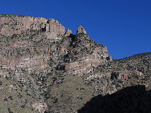
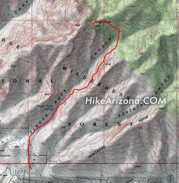
ouch! by climbincajun   From Finger Rock Trailhead at the north end of Alvernon Way follow Finger Rock trail northward 1.1 miles to Finger Rock Spring. From here continue northward for 1.9 miles. After crossing some steep slabs near the edge of the cliff, the trail flattens out onto a large, open promontory above the canyon bottom. Here the trail turns eastward. At this point, you will leave the well-traveled trail, and not likely see anyone for the remainder of the hike. From Finger Rock Trailhead at the north end of Alvernon Way follow Finger Rock trail northward 1.1 miles to Finger Rock Spring. From here continue northward for 1.9 miles. After crossing some steep slabs near the edge of the cliff, the trail flattens out onto a large, open promontory above the canyon bottom. Here the trail turns eastward. At this point, you will leave the well-traveled trail, and not likely see anyone for the remainder of the hike.Do not follow the trail as it turns east toward Mt. Kimball. Instead hike northward, down a steep, obscure path, and across the wash below. This wash bottom is a nice shady place to rest before the final push that lies ahead, especially if water is running. A faint, increasingly steep route marked by cairns (hopefully) will contour to the north back uphill and eventually around the backside of Finger Rock Guard, the large formation immediately east of Finger Rock. As you approach the formations proper, the trail splits, up and left to the Guard, and down and right to the Finger.
Follow the left trail up over a short blocky wall. Some technical scrambling will take you through a short labyrinth of rock formations, and eventually out onto the summit of Finger Rock Guard. Technical gear is not required to reach this summit. Finger Rock Take the steep right trail, first downhill and then up, ten minutes through dense vegetation until it dead-ends at the northwest face of Finger Rock. The views from the saddle below Finger Rock itself are spectacular. The exposure is extreme. The true summit of Finger Rock is a technical climb, details at Finger Rock Summit. Allow at least three hours for the approach, and a little less for the return. This hike is difficult, steep, and loose in many places. Not for the faint of heart. Plan on a full day of hard work.
Check out the Official Route and Triplogs. Leave No Trace and +Add a Triplog after your hike & climb trip to support this local community. | |||||||||||||||||||||||||||||||||||||||||||||||||||||||||||||||||||||||||||||||||||||||||||||||||||||||||||||||||||||||||