Route Editor

| Guide | ♦ | 6 Triplogs | 0 Topics |
details | drive | permit | forecast | 🔥 route |
stats |
photos | triplogs | topics | location |
| 51 | 6 | 0 |
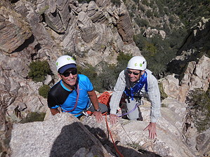
Give me the Finger Anytime! by rvcarter   Introduction IntroductionI’ve been hiking to Finger Rock Guard for several years now and each time peered over at the pinnacle that is Finger Rock with some fear (and some tightening of my lower stomach) and wondered what it would be like to climb it. For the first few trips, looking was enough. That lasted till a couple of years ago when a climber friend moved here from Colorado and got my hiking buddy and me interested in technical climbing. Then, on each trip to the Guard, we would talk about how to get the gear up that long approach to the base, i.e., mules, unsuspecting (and younger/stronger) hiking friends, stashing equipment, etc. Each time, we would retreat down Finger Rock Trail, content with just reaching the Guard and making it back safely, a great achievement at this stage of our lives. Then, we decided we would never get any younger or stronger and finally bit the bullet on the first opportunity this year after hiking restrictions associated with the Bighorn sheep restoration project were lifted. Thanks a million to Mike for carrying the rope. Before going further, a little geography is helpful. Finger Rock is a remarkable rock pinnacle that resembles a finger sitting atop a closed fist, located in the Santa Catalina Mountains north of Tucson. It sits between (and is hidden from view by) two sheer rock formations. On the west is Prominent Point, and on the east is Finger Rock Guard. It is easily visible from the north and south. Exposure on these features is extreme. The top is tiny, room enough for only two or three people, and is characterized by a teetering boulder about 4 feet long and a precariously positioned chockstone, beneath which is a 2x3 foot opening.
To get to the Finger Rock area, one hikes up the Finger Rock Trail # 42 about 2.5 miles to a 90-degree right-hand turn and drops 200 feet into the canyon. From the departure point, the sometimes faint trail is not shown on any hiking maps. From the bottom of the canyon, one heads up to the saddle on the northeast side of the Guard and turns sharply left, and scrambles up the class 3 slope, fraught with huge boulders, cacti, and bushes, to a poorly marked junction. Here, hikers going to the Guard take the left route up the rock chute, and climbers going to the base of the Finger take the right route, descending initially and keeping left along the cliff face till reaching the west saddle between the Finger and Prominent Point. This is where the 80+ feet technical climb begins. The Hike and Climb Mountain Project (which rates this as a 3-star route) has good information about the climb, noting the original rating of 5.8 and the more recent consensus of 5.6. It indicates that two pitches are needed, but our leader did it in one pitch, and we rappelled all the way down in one pitch with a 60-meter rope. I would argue that even the 5.6 rating is high since I didn’t have any trouble climbing it in my hiking boots (I forgot my LaSportivas). However, the exposure and topping out to moving boulders and chockstones with windows will make this climb unnerving to most people. The climb is trad, but there is one eye bolt on the crux a few feet below the top and two excellent anchors with chains at the top. If you want to break it into two pitches, there is a pretty good ledge about halfway up. Our leader placed protection at two points, one a ¾ inch Camelot in the lower part, and clipped a quickdraw in the upper face eyebolt. Your leader may wish to place additional protection, but a set of nuts and cams to one inch should cover most needs. You should also check out bknorby’s excellent triplog and photoset for her December 28, 2013 ascent to Finger Rock. Her pictures make me think they had more photographers along (I don’t think the guys with me even own a camera). See also Finger Rock Guard for the nearby non-technical option. Regardless of which one you choose, the level of accomplishment is considerable, the views to the north and south are outstanding, and you will not soon forget going to either destination. Check out the Official Route and Triplogs. Leave No Trace and +Add a Triplog after your hike & climb trip to support this local community. | |||||||||||||||||||||||||||||||||||||||||||||||||||||||||||||||||||||||||||||||||||||||||||||||||||||||||||||||||||||||||