 Route Editor

| Guide | ♦ | 37 Triplogs | 5 Topics |
details | drive | no permit | forecast | 🔥 route |
stats |
photos | triplogs | topics | location |
| 160 | 37 | 5 |
Hurts like a mother but not a full lode by joebartels   Overview: Overview:• Start Lone Pine TH • over Brown's Peak • down 1-2 saddle • up Peak 2 • return Note Backpacking and dogs are allowed but not recommended. The terrain is harsh and dangerous exposure might be encountered. Climbing experience may be helpful but not necessary. Not recommended when snow or ice is present.
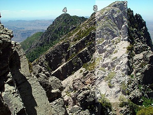
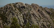
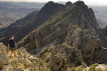
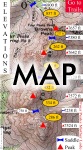
From the summit of Brown's Peak head south (maybe SE) about 50 feet. Tall stumpy grass lets you know you're in the right area. Go down the steep ravine on your right/west. Use the walls for support, as the footing is terrible. The route isn't perfectly defined but you'll figure it out. Halfway down you come to a slanted rock slope (right & below the square box in this photo) You can go down through some hollowed-out shrubs. However, it's easier to just downclimb the slanted rock. If you can't I wouldn't bother with thoughts of Peak #3. You come down on a slanted base, which almost invites you to go right. It may be an easier route, I haven't tried that yet. Instead, I've followed close left on a lightly defined route. It hugs a wall and slightly roller coasters through some painless shrubs & trees. Soon you're at a saddle. There isn't a well-defined saddle. In fact, there are two tiny saddles separated by a big rock hump. Keep in mind the descent to here is less than 1/3 of what it took to summit Brown's Peak. There're probably a dozen routes to Peak #2. Check out the map for two I've plotted. Getting there I definitely recommend the direct route (yellow line). It's probably only a half-hour from Brown's Peak to Peak #2 using this route at a good pace. The tough part is up the tiered level ledges. Personally, I've grown to love this stuff. You pound out maybe a half dozen short climbs generally around 8 feet. It's fun going up but the thought of coming down might turn your stomach. It isn't direct exposure but you know damn well you might die sliding down the mountain. The tiered ledges peter out and you're on a sharp and slanted ridge. If you're not into heights don't look right/west as it's stEEp. (Reverse view looking up) Just when you think you're on the summit you have to keep going. The views from the summit are great, though my favorite views are still from Peak #4. If you're contemplating a full mother lode expedition don't get too excited. The view looking at Peak #3 is a tad deceiving, there's really a 500 foot drop. For this hike, you head back home over Brown's Peak. If you feel uncomfortable going down the tiered ledges you might follow the alternate white route as defined on the map. Keep in mind it has its own less desirable sections. Most notably being the prickly bushwhacking. Take the time to get to know the maze of terrain. You might enjoy deciphering it as much as the Superstition Wilderness, I know I do!
Check out the Official Route and Triplogs. Note This is a moderately difficult hike. Leave No Trace and +Add a Triplog after your hike to support this local community. | ||||||||||||||||||||||||||||||||||||||||||||||||||||||||||||||||||||||||||||||||||||||||||||||||||||||||||||||||||||||||||||||||||||||||||||||||||||||||||||||||||||||||||||||||||||||||||||||||||||||||||||||||||||||||||||||||||||||


