Route Editor

| Guide | ♦ | 14 Triplogs | 0 Topics |
details | drive | no permit | forecast | 🔥 route |
stats |
photos | triplogs | topics | location |
| 182 | 14 | 0 |
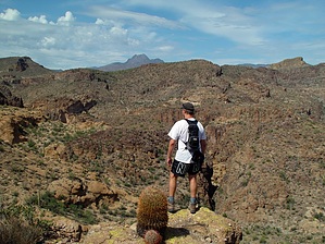
Beauty beyond destination by joebartels  Here's a simple hike into a scenic area few ever see. From Mesquite Flat just east of Tortilla Flats, you take off NW onto a jeep road. The entire hike mentioned here is on the jeep road. In fact, you could drive, but the scenery is better-absorbed hiking. Here's a simple hike into a scenic area few ever see. From Mesquite Flat just east of Tortilla Flats, you take off NW onto a jeep road. The entire hike mentioned here is on the jeep road. In fact, you could drive, but the scenery is better-absorbed hiking.It's a steady rise up the road. Soon the road notches high on the left to go around a ravine with a mini dam of sorts. Continue to the Y intersection. First, I opted for the west extension of the Y. The views are pretty good but not as good as the east extension. You might opt to use this end for further exploration. Most notably would be Peak 2749.
Although nothing mind rattling, I found this to be a pleasant hike even in mid-day August heat. Granted, it was an uncharacteristically cool day with scattered clouds. Photographers would certainly benefit from surrounding thunderstorms. The area doesn't show the horrid signs of abuse I've witnessed in the nearby Tonto Forest. Check out the Official Route and Triplogs. Leave No Trace and +Add a Triplog after your hike to support this local community. | ||||||||||||||||||||||||||||||||||||||||||||||||||||||||||||||||||||||||||||||||||||||||||||||||||||||||||||||||||||||||||||||||||||||||||||||||||||||||||||||||||||||||||||||||||||||||||||||||||||