Route Editor

| Guide | ♦ | 1 Triplog | 0 Topics |
details | drive | permit | forecast | route |
stats |
photos | triplog | topics | location |
| 25 | 1 | 0 |
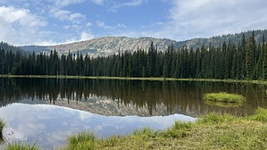
Clockwise Darling by LindaAnn Hike: Starting from the north end of the parking area, head north on the trail marked with a sign '52', which is Lake Darling Trail #52. Shortly into the hike, you will cross a wooden bridge over Gordon Creek. Less than a quarter mile past the bridge, start looking for a sign on a tree to the right for the junction with Gordon Creek Trail #161. The sign will have both trails 52 & 161 marked. At this junction, turn left and head west on Gordon Creek #161.
There is no sign at the junction with the Pend Oreille Divide Trail #67, but the Divide trail is quite obvious, as it is well-worn and much wider than the Gordon Creek trail. At the Divide trail, if you want to add four more miles to your day, you could hang a left and tag Lunch Peak two miles away, then retrace your steps back to this point. Otherwise, make a right and head north on the Divide trail. There are nice views to both the east and west along the trail. After a little over a mile on the Divide, you will reach the well-signed junction with Lake Darling Trail #52. Continue north on the Divide trail another third of a mile to a noticeable fork in the trail. Take the right fork to head uphill to the summit of Mt Pend Oreille. It's less than half a mile to the summit, but you do gain about 450', so it's fairly steep. Enjoy the views as you catch your breath on the way up, especially since there aren't many trees in the way at this point. The west end of the summit has the remains of an old lookout tower scattered about and nice views of the Selkirk Mountains to the west, with the Selle Valley below. The east end of the summit is rockier, with good views of the Cabinet Mountains to your north, east, and south. Once done at the summit, retrace your steps back down and south on the Divide trail to the junction with Lake Darling Trail. Heading down Lake Darling Trail is initially easy, and the grade is not too steep, but in the summer, tons of vegetation encroaches on the trail making it almost impossible to see at times. Heading downhill through this mile or so is easier than trying to find your way uphill, hence the clockwise suggestion for this loop. Despite not being able to see your feet at times, watch your footing as the trail has numerous 6-10" drops or steps. My guess is that this loop would be best in either July or October when the vegetation isn't as bad. Once you cross Lightning Creek, on the west side of Lake Darling, the vegetation eases up a bit, and the trail levels off. The trail will curve around the north side of Lake Darling, finally allowing you some nice views of the lake on the east side. There are several camping spots by the lake, along with a bear locker. Once past the lake, the trail heads south, roughly paralleling Lightning Creek, although you only catch a few glimpses of it. The final two miles of trail are pretty easy, and you will be back to the trailhead in no time. Warning: As numerous signs will remind you, in addition to black bears, this is grizzly country, and moose country as well. Be alert and carry whatever protection is comfortable to you. Check out the Official Route and Triplog. Leave No Trace and +Add a Triplog after your hike to support this local community. | |||||||||||||||||||||||||||||||||||||||||||||||||||||||||||||||||||||||||||||||||||||||||