Route Editor

| Guide | ♦ | 30 Triplogs | 1 Topic |
details | drive | permit | forecast | 🔥 route |
stats |
photos | triplogs | topic | location |
| 411 | 30 | 1 |
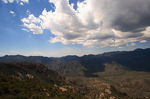
Exploding views by fricknaley   The mighty Chiricahuas rise out of southeastern Arizona and dominate the corner of the state. National park-worthy in their beauty, rugged and isolated they are some of the best hiking in the state, in my opinion, and I love to go there. Silver Peak (roughly 8000 feet) is a good introduction, gets you out of the heat, and knocks your socks off with one of the best summit views I have ever seen. This hike is in the Eastern part of the range, out of the Portal/Cave Creek Canyon area. The trail is a little overgrown in places, but always easy to follow. Not much cover on the lower half so make sure to cover up and bring plenty of water. The mighty Chiricahuas rise out of southeastern Arizona and dominate the corner of the state. National park-worthy in their beauty, rugged and isolated they are some of the best hiking in the state, in my opinion, and I love to go there. Silver Peak (roughly 8000 feet) is a good introduction, gets you out of the heat, and knocks your socks off with one of the best summit views I have ever seen. This hike is in the Eastern part of the range, out of the Portal/Cave Creek Canyon area. The trail is a little overgrown in places, but always easy to follow. Not much cover on the lower half so make sure to cover up and bring plenty of water.The hike starts through a hiker's gate just off the little pull-out on portal road. A small wooden sign announces Silver Peak. Hang right here and follow the trail up and along the road briefly. Sign then points to your left, while a footpath continues onward to some small cottages.
As you wind along the trail, you always are climbing and the valley below continues to fall away. You can almost always see your progress with respect to altitude gain on this hike. A couple of switchbacks here keep you honest but not too many... yet. As you round the mountain the trail begins to switchback more often and there are more stands of vegetation and shade. Great views along the way help too. You can finally see the Silver Peak summit and where you are heading. As you gain more altitude the pine forest kicks in and so do the switchbacks for your final ascent. Lots of shade and fragrant pine now. Huff and puff those last few switchbacks and you stumble upon an old little shed. This is the site of an old lookout that apparently burned down in 1992. Hang a right here and pick up a narrow, small old rock staircase that leads up to the foundation of the old lookout... and be ready. Spectacular panoramic views of the eastern Chiricahuas and the cave creek canyon system explode upon you. This summit is one of the best secrets I know to share with you all. Gate Policy: If a gate is closed upon arrival, leave it closed after you go through. If it is open, leave it open. Leaving a closed gate open may put cattle in danger. Closing an open gate may cut them off from water. Please be respectful, leave gates as found. The exception is signage on the gate directing you otherwise.
Coronado FS Details The Silver Peak Trail offers excellent views as soon as you pass the trailhead sign. This desert pathway is located in magnificent Cave Creek Canyon and provides one of the best opportunities for getting a broad view of the canyon that has been called the Yosemite of the Southwest. This trail is located just a short distance up-canyon from the Cave Creek Visitor Information Center. If you don't want to take a long hike or ride here, at least take a short one, especially if you're just arriving at Cave Creek. The views you'll find along lower stretches of the trail provide an excellent introduction to this beautiful and dramatic area. They may even convince you to take a longer trip, perhaps all the way to Silver Peak's 7,975 foot summit. It's a 3,000 foot climb and anything but easy, however the panorama is unforgettable. The climb starts among desert grassland vegetation, such as sotol and agave, and climbs to the Douglas-fir forests of the Canadian Zone. From higher reaches of the trail, you can see much of the eastern slopes of the Chiricahuas including the canyons that Cave Creek, the South Fork of Cave Creek, and East Turkey Creek have cut into the mountain range. To the east, the extensive grasslands of the San Simon Valley stretch to the Peloncillos and into New Mexico. At the summit, along with the panoramic views, you will see the remains of the Silver Peak Lookout which burned down in an October, 1992, thunder and snow storm. Check out the Official Route and Triplogs. Leave No Trace and +Add a Triplog after your hike to support this local community. | ||||||||||||||||||||||||||||||||||||||||||||||||||||||||||||||||||||||||||||||||||||||||||||||||||