 Route Editor

| Guide | ♦ | 19 Triplogs | 0 Topics |
details | drive | permit | forecast | 🔥 route |
stats |
photos | triplogs | topics | location |
| 64 | 19 | 0 |
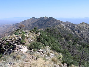
Ridge with a view by fricknaley  NOTE NOTEThis particular trail lies within a region that the Aspen Fire heavily burned. If this bothers you, as I know it does some, you may want to consider other options for now. I still found it to be quite worthwhile for other reasons I'll describe below. Oracle Ridge is a long north running trail that basically descends all the way from Mt. Lemmon to the town of Oracle below (ends in the state park). It was an old mining route. There are numerous saddles and campsites along the way, and I choose to hike out to Dan Saddle and back for a shorter trip. This trail is interesting because it is mostly exposed, but running along at 7000+ feet, the heat is not overbearing. Large views of the northern Catalinas can be seen at all times and to the west (including impressive views of the Reef of Rocks) and east.
Most of the way from here is a gradual descent, though it is occasionally steep. You crest or skirt a couple of minor peaks along the way down. Frequently to the east, you see evidence of the old mining routes far below, as well as the jeep track that appears to ultimately make its way down to Oracle far, far below. At about 2 miles in or so, you intersect an old jeep track. Merge with this and keep following it down. Soon a signed side trail breaks off to your left. This trail weaves and switchbacks its way down and dumps you back on the jeep track again. This happens one more time as well. This time when you are dropped back on the jeep track, a couple more yards down the track places you at Dan Saddle. The trail continues from here, and another route breaks off to the west (Catalina Camp) as a connector to the Red Ridge trail. I turned around here and made the climb back up. Nice views of the Reef of Rocks and Mount Lemmon lie ahead, the whole way back. Check out the Official Route and Triplogs. Leave No Trace and +Add a Triplog after your hike to support this local community. | ||||||||||||||||||||||||||||||||||||||||||||||||||||||||||||||||||||||||||||||||||||||||||||||||||||||||||||||||||||||||||||||||||||||||||||||||||||||||||||||||||||||||||||||||||||||||||||||||||||||||||||||||||||


