This hike takes you from the inner flat calm of South Mountain to the western high point called Goat Hill. Trailhead parking is generous. You might feel all alone in this area built for crowds. During the few weeks of wildflower explosion, the baby-stroller-battalion and quarter-mile-crampers are in full force. In my ten years of hiking, I've witnessed two phenomenal wildflower seasons and a few marginal displays.
Trailhead to Road 0.7mi / 290 ft: The hike starts from the abused lower desert. At a tenth of a mile, you cross through a ravine and then out into the sweeping desert. Be on the lookout for mountain bikers. They can pick up speed on these non-technical low desert trails. Horseback riders also frequent the area. In just over two-tenths of a mile, you reach a signed junction. Derby Loop on the right goes to San Juan Road and Las Lomitas Loop heads left to the Kiwanis Trailhead.
The surrounding desert is fairly lackluster without wildflower displays. Distance city views to the northeast are unique from this angle. At 0.4 miles comes the east end access for the Bajada Trail. Continue on another quarter mile to the beginning of the switchbacks. The trail crosses East Telegraph Pass Road just past its 2.5-mile marker.
Road to National Jnct +0.75 mi / +430 ft: Here the hike gains more interest in some big lazy switchbacks up the mountain. The upper half of this section has a nice feel as you effortlessly conquer what appears to be exhausting. Afternoon shade comes early in the winter months.
Jnct to Goat Hill +0.4 / +345: The deceiving truth never reveals itself. When you reach the National Trail junction your body goes into relief mode. You continue to gain altitude but you won't feel it with the mountain mass looming over you. Any trail runners you cross paths with up here are ribbon/trophy bound whereas the Pima Canyon variety tends to be companion seekers.
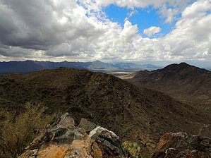
Coming around the south end of the mountain rise watch your step on the steep slopes. This is the most dangerous section of all South Mountain as far as I know. My stomach turns just thinking about mountain biking slips. Goat Hill comes soon after you pass the mine. The turn-off for Goat Hill is subtle but you can't miss it. It's a few tiny switchbacks up to a nice deck.
WARNING! Hiking and outdoor related sports can be dangerous. Be responsible and prepare for the trip. Study the area you are entering and plan accordingly. Dress for the current and unexpected weather changes. Take plenty of water. Never go alone. Make an itinerary with your plan(s), route(s), destination(s) and expected return time. Give your itinerary to trusted family and/or friends.
Permit $$
None
Directions
Road
Paved - Car Okay
To hike From Phoenix, head straight down Central, keep going and going until it hits South Mountain. The road curves west passing an entrance gate. Keep going to the information/bathroom center. Continue west on San Juan Rd. It's left of the Five Tables Picnic Area.
 Route Editor

 This hike takes you from the inner flat calm of South Mountain to the western high point called Goat Hill. Trailhead parking is generous. You might feel all alone in this area built for crowds. During the few weeks of wildflower explosion, the baby-stroller-battalion and quarter-mile-crampers are in full force. In my ten years of hiking, I've witnessed two phenomenal wildflower seasons and a few marginal displays.