Route Editor

| Guide | ♦ | 20 Triplogs | 0 Topics |
details | drive | no permit | forecast | 🔥 route |
stats |
photos | triplogs | topics | location |
| 196 | 20 | 0 |
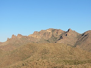
It's French for...The Barge by John10s  Overview OverviewLa Barge Mountain is one of the less commonly visited peaks in the Superstitions but offers impressive views of many of the popular western Superstition landmarks along with plentiful arches and intriguing geology along the way. Reaching the peak requires a round-trip hike of ~9.5 miles starting on JF Trail #106 and following a fence line off-trail most of the way to the top. Hike From Woodbury Trailhead, start hiking up JF Trail, which begins as an unmarked jeep road that's barricaded with a "Road Closed" sign. There's an opening for hikers to the left of the gate, and after a short incline, the road levels out as La Barge Mountain comes into view a few miles away. A little over a half mile in, the jeep road descends to the intersection with Woodbury Trail #114 near a windmill and several water tanks and cattle troughs.
JF Trail continues gradually gaining elevation, and several arches are visible along the western ridgeline--one formation contains at least three arches, and a little farther north in the same area is a larger triangular arch. After gaining more elevation, you'll be able to see Fraser Arch to the south. Cairns help mark the trail through this stretch, which is reasonably easy to follow but may be obscured by overgrowth in some areas. Roughly three miles in, you'll encounter one set of switchbacks before the trail continues up to Tortilla Pass, where JF Trail intersects Rogers Canyon Trail #110. This is where the off-trail portion of the hike begins. There's a barbed wire fence near the intersection; leave the trail and stay on the north side of the fence as you follow it to the southwest. The brush isn't too dense, so it's easy to dodge any larger foliage as you gradually gain elevation. Thanks to the fence, route-finding is about as easy as it gets. After following the fence for three-quarters of a mile, you'll see some larger rock formations and the flat top of La Barge Mountain up ahead as you approach the top of a hill. You'll lose some of the elevation you'd gained as you descend to a small clearing. From there, leave the fence line and continue up the other side of the hill, staying on the north side of the rock outcroppings. Toward the top of the hill, yet another nice arch will come into view. Other than occasional cairns, the route isn't well-defined at this point, but you're close enough to the peak that it's a matter of picking the route that looks easiest as you gain elevation toward the top. If you're following the official route, you can take a short detour through a tunnel that leads to a scenic "balcony" formed by a large, rectangular boulder lodged into the side of a cliff to form a large platform. Enter the tunnel and pass through the other side to enjoy the views, then return to the route and continue along the north side of the rock outcroppings. The last few tenths of a mile leading up to the peak are full of intriguing formations, more arches, some small caves, and a variety of rock outcroppings that make this an interesting area to explore, and reaching the top may require some easy scrambling depending on the route you take. The peak itself is flat, grassy, and fairly nondescript, but the views are impressive. When you reach the top, you'll get your first views of Weaver's Needle and the Superstition Ridgeline to the west, including Peaks 5057 and 5024. Four Peaks and the Salt River corridor dominate the north, and Buzzard's Roost, Fraser 4618, and Picketpost are among the notable landmarks to the south. To the east, you'll see Cimeron and White Mountain. As of 2023, there's a summit register buried in the cairn that dates back to 2002, but the plastic container is in dire need of replacement. Once you've enjoyed the summit, you can start back following the same route or try a steeper, more adventurous descent from the peak--check out the trip logs for alternative routes if you're looking for more variety. Otherwise, work your way back past the rock outcroppings containing the balcony and the arch, then descend the hill to the clearing and follow the fence line back to Tortilla Pass. From there, it's ~3.5 miles on JF Trail back to Woodbury Trailhead. Gate Policy: If a gate is closed upon arrival, leave it closed after you go through. If it is open, leave it open. Leaving a closed gate open may put cattle in danger. Closing an open gate may cut them off from water. Please be respectful, leave gates as found. The exception is signage on the gate directing you otherwise. Check out the Official Route and Triplogs. Leave No Trace and +Add a Triplog after your hike to support this local community. | ||||||||||||||||||||||||||||||||||||||||||||||||||||||||||||||||||||||||||||||||||||||||||||||||||||||||||||||||||||||||||||||||||||||||||||||||||||||||||||||||||||||||||||||||||||||||||||||||||||||||||