Here is a beautiful trail with a couple of major drawbacks. This is a loop hike that can be hiked in either direction. I chose heading out on the South Loop which looking back would be my choice again.
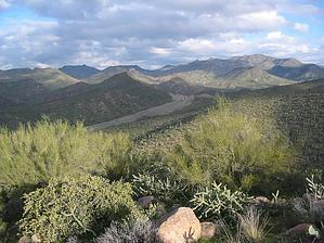
From the start lush desert flora draws you into the hike. Heading south a little the trail hooks back west to ascend the hill/mountain. Highway 87 below has a roaring flow of traffic. It just seemed odd as you can hike in the middle of Phoenix with very little noise. Another drawback is the dense concentration of cattle. Evidence lies everywhere! Now that doesn't bother me, but the flies were unbelievable! I was thinking of turning around yet the trail was so lush I had to check this out. Near the end of the ascent, the vegetation thins out some. Beautiful valleys open up. Saguaros pack the slopes. Standing here I wish there had been recent rainfall. The creeks below would be an awesome sight during monsoon season! Although I would never recommend hiking out in the open during a thunderstorm we can always imagine. From here it is all downhill.
The trail descends to the junction with the Ballantine Trail and our return on Pine Creek North Loop. The sign reads: Ballantine Trail 283 - Boulder Flat 3 miles ahead, Rock Tank 7 miles ahead, and Cline Trailhead 11 miles to go. You could continue ahead passing 'The Boulders' and on up to Pine Mountain. That would be another 5 to 6 miles with an additional 3000-foot elevation gain! I chose to continue on the Pine Creek North Loop. This is a nice trail too. Personally, I prefer the South Loop section. Overall I was impressed with the hike and definitely will return. Of course, I'll bring a case of bug spray!
WARNING! Hiking and outdoor related sports can be dangerous. Be responsible and prepare for the trip. Study the area you are entering and plan accordingly. Dress for the current and unexpected weather changes. Take plenty of water. Never go alone. Make an itinerary with your plan(s), route(s), destination(s) and expected return time. Give your itinerary to trusted family and/or friends.
Permit $$
None
Directions
Road
Paved - Car Okay
To Ballantine Trailhead From Scottsdale follow Shea Blvd East to its terminus at SR87. Turn Left (North) onto SR87. Follow SR87(this is the Beeline) about 9.5 miles past the Four Peaks turnoff. The Ballantine turnoff is easy to find just past Mile Post 210. The trailhead is easy to spot from the parking loop.
From PHX (I-10 & AZ-51) 48.1 mi - about 55 mins From TUC (Jct 1-10 & Grant) 146 mi - about 2 hours 15 mins From FLG (Jct I-17 & I-40) 153 mi - about 2 hours 46 mins
 Route Editor

 Here is a beautiful trail with a couple of major drawbacks. This is a loop hike that can be hiked in either direction. I chose heading out on the South Loop which looking back would be my choice again.