 Route Editor

| Guide | ♦ | 21 Triplogs | 2 Topics |
details | drive | permit | forecast | 🔥 route |
stats |
photos | triplogs | topics | location |
| 165 | 21 | 2 |
Big Trees and a falls by markthurman53   CHIRICAHUA MOUNTAINS CHIRICAHUA MOUNTAINSThe Chiricahua Mountains are located in far southeast Arizona on the New Mexico and Mexico border. This mountain is probably the remotest of the over 9000 feet high sky island ranges. The closest towns are Wilcox, 40 miles to the north, and Douglas, about the same to the south. No paved roads enter this range except a short portion on the east side of the range near Portal, Arizona, and there isn’t any easy way to get there. One dirt road traverses the range from the west side near the Chiricahua Monument and ends at Portal. The remoteness makes for great hiking if you prefer solitude. Many of the trails are in poor condition with a few exceptions, ravaged by the Rattlesnake fire in 1994 and the Horseshoe 2 fire of 2011. If you are into route finding, then this is the place to hike. GREENHOUSE TRAIL #248
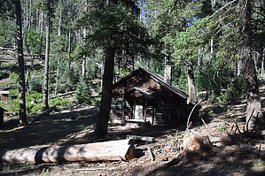
The Greenhouse Trail is one of 2 trails that head up to the Chiricahua Crest from the Cave Creek basin; the other is the Snowshed Trail. The Greenhouse is the shortest of the two, so obviously the steeper. Access to this trail is via FR713, which is near the Herb Martyr Campground. This 2 track road can be taken by a high clearance vehicle. If you choose to walk from the Herb Martyr Campground, you add 1.9 miles more to the hike. The Greenhouse trail is named for the cabin up near the crest, and it looks like it was painted green at one time. The trail starts in a canyon from Round Park up on the crest, which is just south of Flys Peak and eventually runs into Cave Creek. At Winn Falls, the trail crosses over into Cima Canyon and follows that canyon up to the crest. An alternate way to access the Greenhouse Trail is via the Basin Trail #600 off Forest Road 42. This friendly pathway follows a moderate gradient through oak/pine woodland, past Welch Seep, to FR713, where a sign points to the Greenhouse Trail. The Basin Trail is an excellent place to see White Tailed Deer and other wildlife. This trail is also accessible via the Ash Spring Trail #247A out of Herb Martyr Campground. Description The signed Greenhouse Trail Head is at the end of FR713, .9 miles from the Basin Trail #600. There is a sign at the Basin Trail pointing the direction to the Greenhouse Trail. FR713 can be driven all the way to the trailhead with a high clearance vehicle. I seem to remember a barbed wire fence at FR 713 and FR42A. If the gate is closed, close the gate after passing through. If you choose to walk to the trailhead from the Herb Martyr Campground, you add 1.9 miles to the hike. From the trailhead, it is 0.2 miles to the Wilderness boundary. This trail is easy to follow though it doesn’t look like it is maintained. The AEG and the elevation change are the same, so it is a continuous uphill hike except for a 0.5-mile level section. The first .4 miles is along an unnamed creek, and canyon (it is not Green Canyon) that has its origin on the Chiricahua Crest at Round Park, the ridge to the north along this creek is Centella Ridge. This section of trail is pine-covered with a steady uphill but not real steep. Once you leave the creek bed and start climbing up the ridge to cross over to Cima Canyon, the trail gets steep. Luckily they do this next 1 mile and 1000 feet of elevation gain with lots of switchbacks. Halfway up the switchbacks is Winn Falls Vista; this is about the only place to see Winn Falls. It is nice that it is halfway up the climb because it gives you a chance to take a breather and take in the view. After about a half dozen more switchbacks, the trail crosses over into Cima Canyon. For the next 0.5 miles the trail is level as it parallels the creek waiting for it to rise up to the trail. The trail now follows a more gradual course into a mossy basin where big trees and wildflowers flourish on the moisture provided by a perennial stretch of Cima Creek. Cima Canyon is Beautiful. I won’t say it’s the most scenic canyon because there are quite a few in the Chiricahuas, but scenic enough that the rest of the climb up to the crest goes pretty quick. At 3.4 miles in is Greenhouse Cabin. This cabin is in really good shape and is still used occasionally by the Forest Service Trail and Fire Crews. The sign also says everyone else keep out (they used more polite language, though). A short 0.3 miles after the cabin is the Crest Trail #270. At the trail junction is a sign for the Greenhouse Trail; look down because the sign is pretty short, almost like it is being sucked into the ground. This trail is in good condition along the whole route and looks to get moderate use. Though a long one, a popular loop hike is the Greenhouse, Crest, Snowshed, and Herb Martyr Trails. Winn Falls is liable to be dry in early summer, but it becomes a 400-foot icicle in winter, but even if it's only a bare cliff, it's still worth a look. Gate Policy: If a gate is closed upon arrival, leave it closed after you go through. If it is open, leave it open. Leaving a closed gate open may put cattle in danger. Closing an open gate may cut them off from water. Please be respectful, leave gates as found. The exception is signage on the gate directing you otherwise. Check out the Official Route and Triplogs. Leave No Trace and +Add a Triplog after your hike to support this local community. One-Way Notice This hike is listed as One-Way. When hiking several trails on a single "hike", log it with a generic name that describes the hike. Then link the trails traveled, check out the example. | |||||||||||||||||||||||||||||||||||||||||||||||||||||||||||||||||||||||||||||||||||||||||||||||||||||||||||||||||||||||||||||||||||||||||||||||||||||||||||||||||||||||||||||||||||||||||||||||||||||||||||||||


