 Route Editor

| Guide | ♦ | 7 Triplogs | 0 Topics |
details | drive | permit | forecast | 🔥 route |
stats |
photos | triplogs | topics | location |
| 49 | 7 | 0 |
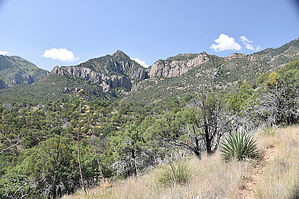
Cave Creek Basin Traverse by markthurman53   CHIRICAHUA MOUNTAINS CHIRICAHUA MOUNTAINSThe Chiricahua Mountains are located in far southeast Arizona on the New Mexico and Mexico border. This mountain is probably the remotest of the over 9000 feet high sky island ranges. The closest towns are Wilcox, 40 miles to the north, and Douglas, about the same to the south. No paved roads enter this range except a short portion on the east side of the range near Portal, Arizona, and there isn’t any easy way to get there. One dirt road traverses the range from the west side near the Chiricahua Monument and ends at Portal. The remoteness makes for great hiking if you prefer solitude. With a few exceptions, many of the trails are in poor condition, ravaged by the Rattlesnake fire in 1994 and the Horseshoe 2 fire of 2011. If you are into route finding, then this is the place to hike. BASIN TRAIL #600
The Basin Trail #600 is a 5.4-mile trail that connects Forest Road 42 to the Herb Martyr Trail #247 near the Herb Martyr campground. This trail Traverses the western slopes of Cave Creek Basin, offering views over Cave Creek Basin to the east and Chiricahua Ridge to the west. Min and max elevation change is only 350 feet but has an AEG of almost 1000 feet because of the multiple creeks and ridges it crosses. Areas of this trail are fairly exposed since the trees are mainly short oak, pine, and juniper, offering very little shade. Where the trail crosses the creeks coming down the east slopes of the Chiricahua Ridge, the tree cover becomes thicker, and large pines are more prevalent. This is not a real exciting trail, it just traverses the Cave Creek basin, but it does have its fine points. Unless you are doing a car shuttle, there are no real good loop hikes with this trail, mainly an in and back. Description The north trailhead along FR42 is 16 miles from the west end of FR42 or 7 miles from the east end, Portal. There is plenty of parking available, but I’ve never seen a crowd on this trail; in fact, I’ve never seen a car here. The trail starts on a two-track and rapidly becomes a single-track trail before crossing the first creek. This creek does not have a name that I am aware of, but its origin is the north slope of Flys Peak near Tub Spring. The trail is in good condition, and no real need for route-finding skills. After crossing Flys Creek (that’s what I’ve called it), the trail climbs 600 feet to a ridge that separates Flys Canyon from Greenhouse Canyon. Once on the ridge, it is a short 0.25 miles down to Welch Seep. There was a water trough there, but when I was there, it was pretty dry. The trail is pretty much downhill for the next 1.5 miles to Greenhouse Canyon and FR713. There is Lots of exposure along this section. FR713 is the road that can be taken to the Greenhouse Canyon Trailhead, 4WD or high clearance with some required skills. Once near Greenhouse Canyon, the tall pines kick in, and the trail is less exposed to the sun. The trail now follows along FR713 for ¾ mile where the Basin Trail leaves the road and heads up about 200 feet to Ash Spring at Cima Creek, FR713 heads east down to the Herb Martyr Road FR42A. The Ash Spring Trail #247A heads east down to the Herb Martyr Camp Ground. From Ash Spring to Clear Creek is downhill for about 1 mile through some pretty lush forest ending at Clear Creek and the Herb Martyr Trail. It is 0.2 miles down the Herb Martyr Trail to the Herb Martyr campground. The last portion from Cima Creek to Cave Creek and the Herb Martyr Trail is pretty scenic. Tall pines and fir trees are dominant, and the Juniper and oak secondary. When I was there in September, the creeks were dry except for Cave Creek, which had a light flow. 2020 was a dry monsoon year, so I’m not sure what it would be like on a normal year. Ash Spring is a perennial spring and had a light trickle. Deer are pretty plentiful around the campground and appear to be quite used to human activity. Check out the Official Route and Triplogs. Leave No Trace and +Add a Triplog after your hike to support this local community. One-Way Notice This hike is listed as One-Way. When hiking several trails on a single "hike", log it with a generic name that describes the hike. Then link the trails traveled, check out the example. | ||||||||||||||||||||||||||||||||||||||||||||||||||||||||||||||||||||||||||||||||||||||||||||||||||||||||


