Route Editor

| Guide | ♦ | 57 Triplogs | 0 Topics |
details | drive | no permit | forecast | 🔥 route |
stats |
photos | triplogs | topics | location |
| 487 | 57 | 0 |
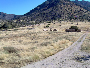
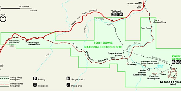
A Hike Through the Old West by IRIE_LION   This hike has a lot of history to offer! With a rich past in Native history (Cochise and Geronimo) and the conquest of the American West by the US. The Trailhead to Fort Bowie begins from a parking lot on the graveled Apache Pass Road that runs south from the town of Bowie, or east from Ariz. 186. A 1.5-mile (3-mile loop) interpretive trail gives all the details of the history that occurred in the area. The first trail junction from your left is the return route so stay on the trail heading straight. This hike has a lot of history to offer! With a rich past in Native history (Cochise and Geronimo) and the conquest of the American West by the US. The Trailhead to Fort Bowie begins from a parking lot on the graveled Apache Pass Road that runs south from the town of Bowie, or east from Ariz. 186. A 1.5-mile (3-mile loop) interpretive trail gives all the details of the history that occurred in the area. The first trail junction from your left is the return route so stay on the trail heading straight.The first ruins to be seen is an old miner's cabin sight. The famous Butterfield Overland Trail can be seen along with the ruins of its stage station. Next comes the post cemetery where some civilians killed by Apaches along with "Little Robe" one of Geronimo's sons still rest. The U.S. Army casualties had been moved to San Francisco in 1895. The next sight is the ruins of the adobe foundation of the Chiricahua Indian Agency which hints at the spirit of cooperation that existed during the first years of the Chiricahua Reservation.
Next comes the ruins of the first site of Fort Bowie, a smaller fort situated on top of a small hill which a small side trail leads to 1/8th of a mile away. Retrace back down the trail to head up east to the much larger ruins and the grand site of the second Fort Bowie ruins. There is a visitor center filled with artifacts, pictures, and books about the area. Water is available outside of the visitor center. Also, note that this does not get an extreme amount of visitors due to the fact the only way to access the ruins is by the 3-mile loop hike. So you may have the place to yourself. The return trail heads up to Vista point which a small and steady climb to the top of a hill will give an overview of the sites of the forts, and also give a good vantage point of the valley. The trail then switchbacks back down the hill to intersect with the trail you started on. This may be a little rough for small children, but I would rate it slightly moderate. This is a hike to do if you like to hike to see historic sights, and this trail by far gives a great tour through the history of the area. At times it seemed as if I had traveled back in time.
Check out the Official Route and Triplogs. Leave No Trace and +Add a Triplog after your hike to support this local community. | |||||||||||||||||||||||||||||||||||||||||||||||||||||||||||||||||||||||||||||||||||||||||||