 Route Editor

| Guide | ♦ | 475 Triplogs | 16 Topics |
details | drive | permit | forecast | 🔥 route |
stats |
photos | triplogs | topics | location |
| 5k | 475 | 16 |
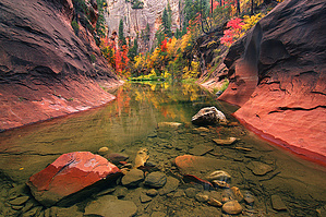
#1 Hike in Arizona! by joebartels  West Fork of Oak Creek is a canyon you won't forget. A crisp morning hike here in Autumn foliage pretty much sealed the deal that I'm a hiker for life. West Fork of Oak Creek is a canyon you won't forget. A crisp morning hike here in Autumn foliage pretty much sealed the deal that I'm a hiker for life.A few minutes into the hike, you cross a bridge built in the summer of '98. The steep climb in and out of the creek was a mini adventure you now admire from above. After crossing the bridge, the trail turns left. Follow the trail overlooking the creek on your left. A spectacular field of ferns opens up to your right. It is the former site of the Lolomai Lodge. Operation faded out around 1920. Zane Grey wrote Call of the Canyon at the lodge. Scattered throughout the field are old apple trees. Shortly before reaching the creek, lush, and I mean lush paths welcome the hiker. West Fork is one place I can truly say I'm glad I can't bring my mountain bike. You wouldn't want to screw up something so perfect.
Keep in mind your feet are going to get wet; it's part of the fun. For years I wore Teva river sandals for good traction. Running shoes are my preference now in my 40s as I'm not as agile as a boy scout. Whatever you wear, be careful on the slippery rocks in the creek. The canyon walls loom overhead, giving a warm feeling. The creek winds back and forth, opens up, narrows, deep pools, shallow pools, tiny cascades you name it. Oak Creek is incredible. Parking on any beautiful summer weekend or during fall foliage can be a hassle. I hiked the creek winter of '98 to see the flip side. The feeling was rather eerie. Camping You must travel 6 miles up the canyon to camp, which is 3 miles past the maintained trail. It is not a dry hike. The creek is perennial. Building, maintaining, attending, or using a fire, campfire, or stove fire is prohibited in the West Fork of Oak Creek Canyon. Backpacking stoves or propane stoves are allowed.
Coconino FS Details There are a number of reasons why West Fork is the most popular trail on the Coconino National Forest. You'll know some of them once you've strolled beside the pleasant little stream that ripples along the canyon floor and looked up, way up, at the dizzying cliffs that tower above it. You'll know even more if you come in the spring, when migrating songbirds decorate the trees with flashes of brilliance, or in the fall when pastel leaves float in clear reflecting pools under a canopy of solid color. You can even add to that list if you come in the winter, when icicles hang from red rock overhangs and snatches of snow persist in cool shadows. As a matter of fact, you'll probably find a new reason to be here every time you visit. As for the trail itself, it's an easy stroll, but you do have to cross the stream in a number of places. Usually, that involves negotiating a few strategically placed stepping stones or taking a couple of steps in shallow water. The trail is marked for the first three miles; however, many hikers continue beyond that. Eventually the pathway ends and you will be forced to hike in the stream bed as you continue into the Secret Mountain/Red Rocks Wilderness. If you choose to travel all 14 miles from one end of the canyon to the other, plan to do a lot of wading and boulder hopping, and even some swimming. No matter how long a hike you take here, you'll enjoy it best if you come at a time when the trail is least crowded. Mornings and weekdays are best, better yet if they're in the off-season. When you do come, remember to take special care and leave this beautiful place better than you found it. Of course you know not to litter, but picking flowers and autumn leaves can cause just as unsightly a scar. So can short-cutting or rock throwing. Treat this natural treasure with the care it deserves and you'll have plenty of reason to come back and see it again and again.  During summer, fall color, spring break, and other busy times of the year, Call of the Canyon (West Fork Trailhead) parking fills up every day by 9:30 a.m., seven days per week. Have a backup plan for a different hike or day use area if the parking lot is full. Parking along the road is extremely dangerous, and damages soils and vegetation. Check out the Official Route and Triplogs. Leave No Trace and +Add a Triplog after your hike to support this local community. | |||||||||||||||||||||||||||||||||||||||||||||||||||||||||||||||||||||||||||||||||||||||||||||||||||||||||||||||||||||||||||||


