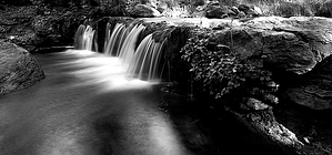
Horton Creek Trail #285 is the most popular day hike in the area. Horton Spring is an unusually large spring. Water gushes from the side of the rim, supplying Horton Creek. Think of the Rim as a huge sponge, and Horton Spring is the faucet. Okay, on to the trail. Starting from the parking area, cross the concrete bridge. Continue on the pavement up the hill heading towards the campgrounds. The trailhead is on the left side of this road. Check out the trail information and hit the trail. First, you will go down and cross the creek. The creek is typically dry in this area as it runs underground in limestone caverns for the first half-mile. The trail is wide and easy to follow, as it's an old jeep trail. Before then, it was just a narrow trail to connect homesteads in the area.
One of which was L.J. Horton, a cattlemen that settled near the creek. Horton lost his heard to thieves and never ranched again. The trail is fairly straight forward for the first three miles. In the final mile, the trail switchbacks to ascend the hill. ( 2015: rerouted lower near the creek ) Just before the springs, you will encounter an intersection with the Highline Trail #31. Go right from the intersection a short distance to reach the springs. The area here is lush, enjoy.
My sister claims to have walked the length of the creek. This would be a lot of fun though more exhausting. Many little waterfalls and some pools are encountered along the way. Keep in mind the going is much slower in the creek. Set aside the whole day for a creek venture. The trail is not too exerting energy-wise. The elevation gain is vaguely noticed. Families with children over the age of ten frequently hike this trail on weekends.
WARNING! Hiking and outdoor related sports can be dangerous. Be responsible and prepare for the trip. Study the area you are entering and plan accordingly. Dress for the current and unexpected weather changes. Take plenty of water. Never go alone. Make an itinerary with your plan(s), route(s), destination(s) and expected return time. Give your itinerary to trusted family and/or friends.
Permit $$
no fees or permits reported
if incorrect tell us about it
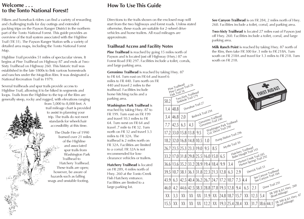
Directions
Road
Paved - Car Okay
To Horton Trailhead
From Payson take 260 East for 16 miles to FR289 which is Tonto Creek Road. Turn left on to FR289 and follow a mile to the Upper Tonto Creek campgrounds. Hiker parking is before the campgrounds (left) across a bridge in a small lot. A composite toilet is available.
Horton Creek Trailhead cross back over the bridge and follow the dirt road up towards the campgrounds for about 150 feet. The trailhead should now be apparent on the left.
Derrick Trailhead2015 Update! New trailhead for the Derrick trail about 200 yards before the Horton Spring Trailhead/Parking. There is a large parking lot and new Outhouse opposite the Trailhead.
Note: If the trailhead parking lot is full the campground host may or may not allow you to park for a fee in the campground. It varies year to year so it's good to ask first.
From PHX (I-10 & AZ-51) - 105 mi, 2 hours 2 mins From TUC (Jct 1-10 & Grant) - 203 mi, 3 hours 32 mins From FLG (Jct I-17 & I-40) - 130 mi, 2 hours 32 mins
 Route Editor


 Horton Creek Trail #285 is the most popular day hike in the area. Horton Spring is an unusually large spring. Water gushes from the side of the rim, supplying Horton Creek. Think of the Rim as a huge sponge, and Horton Spring is the faucet. Okay, on to the trail. Starting from the parking area, cross the concrete bridge. Continue on the pavement up the hill heading towards the campgrounds. The trailhead is on the left side of this road. Check out the trail information and hit the trail. First, you will go down and cross the creek. The creek is typically dry in this area as it runs underground in limestone caverns for the first half-mile. The trail is wide and easy to follow, as it's an old jeep trail. Before then, it was just a narrow trail to connect homesteads in the area.
 One of which was L.J. Horton, a cattlemen that settled near the creek. Horton lost his heard to thieves and never ranched again. The trail is fairly straight forward for the first three miles. In the final mile, the trail switchbacks to ascend the hill. ( 2015: rerouted lower near the creek ) Just before the springs, you will encounter an intersection with the Highline Trail #31. Go right from the intersection a short distance to reach the springs. The area here is lush, enjoy.