| | -
-
-
-
| |  |
|
1 |
-
-
-
-
-
-
-
-
-
-
-
|
| | |
| |
| |
| Linked |
|
none
[ show ]
| no linked trail guides |
| Partners |
|
none
[ show ]
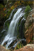
| no partners | | I caught a glimpse of this waterfall a few months back in an Arizona Highways magazine and decided it was a place that I needed to see. After doing a little research, collecting five different maps and directions from the "locals" I headed off on this fun little adventure with a friend. It has been referred to as an "emerging Eden".
The long drive was going as planned until we hit Pacheta Lake. We had been informed that the unmarked start of this hike was about 3 miles beyond Pacheta Lake, which is true, I think. Finding this starting "spot" proved to be exceptionally difficult and an adventure in itself. Signing on the back roads of the Reservation land is anything but clear. Eventually we realized we were in the wrong place. We stopped, twisted the map around a few times and started to head back to the lake and attempt the route again. Just about that time a fine Reservation Law Enforcement officer for the wildlife and outdoor recreation drove up and checked our permit. Who would have thought that on all those dirt roads out in the middle of no place that we would be fortunate enough to have this guy cross our path???!! (FYI--none of the maps are correct, heard there is ONE good one but it is kept under lock and key) Some how we managed to talk this guy into giving us a full escort straight to the start of this hike... wooohoo! Pretty sure it was the peanut butter sandwich I offered him or the thought of having to come back to find us if we were reported missing.
We lost a lot of time but had some great wildlife sightings (monster elk, turkey, coyote) on those back roads; it's a gorgeous area. By the time we started the hike it was late afternoon and we were pressed for daylight. From the unmarked starting point we followed Pacheta Creek for about 45 minutes, crossing it several times as necessary. The creek was shallow and a very comfortable temperature so getting in the creek really wasn't an issue. Most of this route is best done on the West side of the creek on a faint but noticeable footpath. As you approach the falls you will need to be on the East side of the creek. The area is beyond beautiful and filled with lots to see....In hindsight I'd recommend wearing pants.
The falls were absolutely spectacular to witness. Everything was so pristine and undisturbed, truly an "emerging Eden". The sights and sounds of this 131-foot waterfall literally took my breath away. There is a bit of exposure involved to get pictures so much so that it made me a bit nervous when my dog wandered near the edge. In a couple of places I felt the urge to sit down rather than stand. The cliffs that we took the pictures from didn't appear to have any routes down to the bottom of the falls but we didn't look super hard because we were pressed for daylight. We'll have to investigate that further in the future. We managed to get turned around AGAIN (only for an hour or so of "extra" travel this time) on the way back to Pacheta Lake, where we camped for the night. A compass, GPS and lots of patience would come in handy for this one! |
| _____________________
| | |
|
|
|
|
|
| |
 Route Editor


