| | -
-
| 1 label | 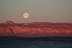 |
|
2 |
-
-
-
-
| 1 label | 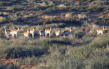 |
|
|
-
-
| 1 label | 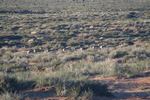 |
|
|
-
|
| | |
|
| Hiking | 1.00 Miles |
|
| | Hiking | 1.00 Miles | 30 Mns | | 2.00 mph |
| | | |
| |
| Linked |
|
none
[ show ]
| no linked trail guides |
| Partners |
|
none
[ show ]
| no partners | | Wiregrass Canyon
This was more an exploratory "look-see" in anticipation of a future adventure. First note; the trail head isn't as marked by HAZ near Hwy 89. At Big Water, take Smoky Mountain Road (Rec. Road 230) east along the north shore of Lake Powell. About 5 miles from Hwy 89, you will cross Wiregrass Canyon. Second note; TH GPS coordinates are 37o 04.830'N, 111o 34.969'W.
We had plenty on our plate this Sunday hiking Coyote Buttes (The Wave), Antelope Canyon, and Horseshoe Bend View. Spent an "interesting" Saturday night in Page checking out the night life (not)... |
| _____________________
| | |
|
|
|
|
|
| |
 Route Editor


