| |
| BCT Day 2 - Off Trail, AZ | | -
-
-
-
-
-
-
-
-
-
-
-
-
-
| 1 label | 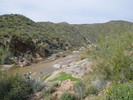 |
|
|
-
|
| | BCT Day 2 - Off Trail, AZ | | | |
|
|
BCT Day 2 - Off Trail, AZ
| | |
|
| Backpack | 13.21 Miles |
1,106 AEG |
| | Backpack | 13.21 Miles | 1 Day | | |
| 1,106 ft AEG | | 22 LBS Pack | | |
|
|
| |
| Linked |
|
none
[ show ]
| no linked trail guides |
| Partners |
|
none
[ show ]
| no partners | | I was in deep sleep when my alarm sounded at 5 am. Snoozed a couple of times before stirring and finally made it on the trail at 6:20. I seemed to have to stop frequently to adjust things, or get food, or get a drink. I was having trouble getting in the groove. This was a nice section of trail to start though because as the sun rose, it lit up the west side of the Bradshaws. That was better than coffee.
Not too far from the Gloriana trailhead, I passed a nice running stream. There were some nice pools a short ways off the trail too. I had water cached at the trailhead so I continued to it. I filled up all my water and drank a bunch too. There were some mountain bikers at the trailhead and I talked to them for a bit and they took the water jug so I wouldn't have to come and get it later.
I left with close to a gallon of water and about three miles later I crossed a small canyon with pools of running water. I asked myself why I was carrying so much water when it was so readily available. I stayed greedy though and kept all I had.
Not far after, the trail crosses Maggie Mine Rd and drops down an old stage coach road to Black Canyon Creek. The path is steep at times and rough but there were more and more wildflowers along the path as I descended. I was hoping Black Canyon Creek wouldn't be running high, but my first view of it showed otherwise and had me worried. Not long after, I was looking down to where the trail crosses the creek, and it was running very swift.
When I got to the creek, I wasn't comfortable crossing right there. The creek widened a lot upstream a ways, but there are cliffs between there and the trail and I didn't want to climb the canyon walls and cut back across to the trail. Downstream, I found a place where the flow was slow but deep. I felt I probably could safely swim across there, then work my way back to the trail.
I don't know if it was because I was tired but I knew that if I crossed here, I would still need to cross the Agua Fria three times later today. I knew what the Agua Fria was like when I crossed it yesterday along with Big Bug Creek and who knows how many other streams were feeding the Agua Fria, including this creek, so I decided to be safe and call my hike. That decision just took all the wind out of my sails and I slowly slogged my way back up to Maggie Mine Rd.
Once at Maggie Mine Rd, I called home trying to figure out a ride from Black Canyon City. While doing that, I received a text from my friend who hiked the BCT with me last year asking if I had a good swim. Turns out he was waiting at the North Agua Fria river crossing with an inflatable boat to ferry me across. If only I had known. Ha. At any rate, I followed Maggie Mine Rd until he came the other way and gave me a ride home. |
|
Wildflowers Observation Light
Fair bit of Poppies between Maggie Mine Road and Black Canyon Creek. Should be heavy in the next week or two. |
|
| _____________________
| | |
|
|
|
|
|
| |
 Route Editor


