| | -
-
-
-
| 1 label |  |
|
|
-
| 2 labels | 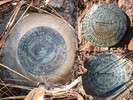 |
|
4 |
-
| 1 label | 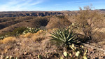 |
|
|
-
| 1 label | 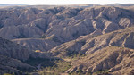 |
|
1 |
-
| 1 label | 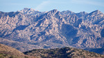 |
|
|
|
| | |
|
| Hiking | 1.39 Miles |
229 AEG |
| | Hiking | 1.39 Miles | 34 Mns | | 2.88 mph |
| 229 ft AEG | 5 Mns Break | | | |
|
|
| |
| Linked |
|
none
[ show ]
| no linked trail guides |
| Partners |
|
none
[ show ]
| no partners | | Saw this BM on the map and was in the area anyway so I decided to investigate.
The old road hasn't seen much traffic over the years so at some point I bailed and proceeded by foot. There are some impressively built cairns up here (4-feet tall, wire enclosed). Except for the pair where the road crosses the boundary between Sections 8 and 17, the others seemed a bit excessive and for no apparent reason.
Anyway, the benchmark and two reference marks were easily found. The BM will be hidden by an agave growing right next to it unless somebody hacks it back. There's lumber and wire from an old survey structure or height of light.
I was surprised to find a register here. It's not even the highpoint on the ridge it's on, nevermind any other kind of spot that folks usually check off a list. It's just a benchmark. I guess I'm not the only weird person out there! |
| _____________________
| I'm not sure what my spirit animal is, but I'm confident it has rabies. |
| | |
|
|
|
|
|
| |
 Route Editor


