| | -
-
-
-
-
-
-
-
| |  |
|
1 |
-
| 1 label | 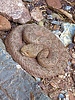 |
|
|
-
-
-
-
-
-
|
| | |
|
| Hiking | 29.88 Miles |
5,810 AEG |
| | Hiking | 29.88 Miles | 11 Hrs 44 Mns | | 2.68 mph |
| 5,810 ft AEG | 36 Mns Break | | | |
|
|
| |
| Partners |
|
none
[ show ]
| no partners | | After spending an evening in the North Rim cabins, I hit the North Kaibab TH with my daughter and son in law and some friends about 5:30 a.m. Temperatures were very mild. Forecast was for 44 degrees (usually is in the 30s). Hiked via headlamp for the first mile or two.
The Canyon was still a bit hazy from wildfires(?) This obscured the usually dramatic view that greets you when you pass through Supai Tunnel. That said, the air seemed to clear as the day wore on.
The upper part of NK trail is in pristine shape--smooth sailing.
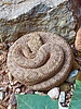
At Manzanita Rest area, there was a nice Grand Canyon pink rattlesnake right on the trail near where you step down into the rest area (a relatively high traffic spot). He/she was coiled up tightly and apparently in a sound snooze. Despite the traffic, he was just sat there unfazed. Cool looking.
At Ribbon Falls, they have now completely removed the remains of the defunct bridge. After climbing over the hill, we backtracked up to the falls via the "south route." Where this used to be more of a "choose your own adventure," the trail to the falls from this end is much more defined these days. The creek crossing still requires a bit of balance and carefully planned hops, but much less chance of dunking yourself than in times past (depending, of course, on water levels).
This was a first R2R for my daughter and SIL, so I convinced them that the side trip was well worth the extra mileage. They looked a little skeptical, and I realized that the snippet of Ribbon Falls that you can see from the N. Kaibab trail doesn't really look that impressive. I told them to withhold judgment until they got up close and personal with the falls.
They relented, and as expected, once we got to the falls, they agreed that it was extra time/energy well spent. As an added bonus, we had the falls essentially to ourselves, with only two other people there--who were on their way out when we arrived. We crossed paths with several other incoming hikers on our way back to the NK trail.
Back on NK, we descended into the Box, where it was evident that monsoon flooding had ravaged the canyon recently. At the mouth of several of the side drainages, a lot rock and silt had reshaped/overrun the trail, causing re-routing. In a couple of places, there were some small rock slides that you now have to maneuver over or around. I don't think I have seen that much change in the trail over a one-year period at any point in the past.
We stopped at Phantom Ranch to fill up some water for lunch, then moseyed down to the shade of the cottonwood trees by the campground to eat while soaking our feet in the creek.
Refreshed and with a fresh set of socks, we began the challenging part of the hike.
My daughter and SIL were in good spirits as we crossed the river and traversed the river trail.
Having done the side hike to Ribbon, we were bringing up the tail end of our group. However, we caught up with a couple just below Devil's Corkscrew (they ended up finishing under headlamp around (9:20 pm). We caught several more at Indian Garden and between there and the top (where there is typically a lot of "carnage"). :-)
We lucked out with some nice cloud cover ascending the corkscrew. I was up for taking a dip in the "jacuzzi" pools off to the side of the trail at the top of the corkscrew, but my daughter was dialed in and intent on keeping the pace. So ..., another time.
From Indian Garden to the base of the ramp where the real climbing starts, we had full sun, and felt the draining heat. That said, as we approached the "ramp," we hit shade and it was an immediate 15-degree drop in temperature. In addition, the sun was soon far enough west to cast a shadow on the trail, providing welcome shade for the remainder of the ascent.
After Jacob's ladder, we took a short break at 3 mi. resthouse, and then kept grinding upward. I was impressed with my daughter and SIL, who kept a great pace on the climb.
Less than a mile from the top, we came across some bighorn sheep--first, a young one and his/her mother, and then dad came bounding across the trail right in front of us, another switchback up. It's still amazing to me how effortlessly they seem to navigate the insanely steep slopes.
After topping out, we were disappointed to here that the Mather campground showers were closed at 12:45 because the GC doesn't have enough employees to keep them open all day. :-(
As an alternative, there is a water spigot with a hose in the "rock garden" by the trailhead bathrooms, so we stripped down to our spandex and hosed ourselves off. It wasn't a hot shower, but could have been colder. In any event, it was more refreshing that driving back to Phoenix in our canyon-caked state.
Stopped for some greasy food at Wendy's in Tusayan, where they are still in drive-thru-only mode. Not sure if that is still a COVID thing, or if they are short on employees as well.
In any event, another memorable trip through the canyon in the books. This place never disappoints! |
| _____________________
| | |
|
|
|
|
|
| |
 Route Editor


