| |
| Moose Lake and Low Pass, WA | | -
-
-
-
-
| 1 label | 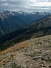 |
|
1 |
|
| | Moose Lake and Low Pass, WA | | | |
|
|
Moose Lake and Low Pass, WA
| | |
|
| Backpack | 30.00 Miles |
7,400 AEG |
| | Backpack | 30.00 Miles | 2 Days | | |
| 7,400 ft AEG | | | | |
|
|
| |
| Linked |
|
none
[ show ]
| no linked trail guides |
| Partners |
|
none
[ show ]
| no partners | | The Hurricane Ridge lodge burned this spring and the road is closed while they investigate. I took this as an opportunity to visit Badger Valley while the usual crowds were discouraged by longer access. And it was pristine! Company from only two other backpackers and theirs were the only other tracks I saw.
I had cloud inversions and peekaboo peaks to keep me entertained along Deer Ridge. I left the trail just before Obstruction Point and traversed to two basins with pretty little tarns. There were fish in the shallow tarn nearest the parking lot and I'd be surprised if they aren't recent transplants. I followed deer trails but they were nothing as nice as in the canyon: it seems these high slopes have such a short snow-free season that good trails can't get worn in. There is clay underlying the scree and it becomes saturated and packed, then dries so hard you can't kick in steps. Now I understand why mountaineers prefer steep snow to rock! The meadows hardly offer better footing because the vegetation is slippery. I didn't have time to visit a third basin with several tarns but it looked the prettiest of all.
Back on the ridge, I had fantastic views of dark clouds, the Bailey Range, and Mt Olympus. I hustled down to Moose Lake where the mosquito pressure was still light. There were several deer, including one tiny fawn. It was a beautiful evening but, like last summer, I wanted to play with the pup at home rather than camp.
I'd left my fly at home and woke up covered in dew once again. I ran into my neighbors, who were bailing with sudden thunderstorms in the forecast. Without a fly, I would have to bail too. First I took a couple hours to hike up the valley to Low Pass. The trail there is abandoned and marmots dominate the meadow. Lillian Basin, below me, looked tempting.
The clouds rolled in fast. I broke camp and made it about 1/3 out before it started raining, then hailing. Still barely below treeline, I stayed mostly dry while waiting the storm out. The t-storms passed so I felt comfortable enough to climb back up to the exposed ridge for my hike out. I was treated to purple clouds and virga near Deception Basin. |
| | |
|
|
|
|
|
| |
 Route Editor


