username
X
password
register
for free!
help
ArticlesGuidesRoutes
 
Photosets
 
 Comments
triplogs   photosets   labels comments more
Handies Peak - 7 members in 14 triplogs have rated this an average 5 ( 1 to 5 best )
14 triplogs
login for filter options
Aug 05 2023
avatar

 Guides 37
 Routes 556
 Photos 10,872
 Triplogs 1,052

43 male
 Joined Jan 21 2013
 AZ
Handies PeakWest, CO
West, CO
Hiking avatar Aug 05 2023
FOTGTriplogs 1,052
Hiking8.60 Miles 3,662 AEG
Hiking8.60 Miles   7 Hrs   50 Mns   1.57 mph
3,662 ft AEG   2 Hrs   22 Mns Break
 
1st trip
Linked   linked  
Partners none no partners
Route Scout Route Recorded  on Route Scout | Pop | Map | Popup | MapDEX
We made the short drive up from the valley Friday night to knock out Katie and her friends first 14er. We opted for the Grizzly Gulch approach to Handies to avoid the rough road to the American Basin TH.

We got a pretty late start (6:14 a.m.) by 14er standards, but with two straight sunny days in the forecast and not even a mention of rain, we felt we could cheat a little on our start time. We kept a very pedestrian pace and took extended breaks after each of the first three miles to make sure it was a good experience for Katie and her friend. The strategy paid off and we all made the summit on about as good a day one can ask for in those mountains in the summer. We spent a few minutes on the summit and then repositioned to a slightly lower elevation to get away from the crowds, where we took yet another extended break. We actually took well over two hours worth of breaks on the day and really took in our surroundings and tried to enjoy the area to the fullest. Handies was the only thing scheduled for this long weekend trip, so we were in no rush to get back to driving.

The first mile or so coming down from Handies is a bit steep and hard on the knees, but the views are pretty stunning and it goes by quickly. We took another nice long break at one of the tarns below Handies, before finally making a meaningful attempt at finishing our hike, however, a nice display of wildflowers along the way slowed our pace.

The final stretch to the trailhead got a little warm and my knee could have done without the "stairs," but it was still a pleasant final couple of miles through the woods. Dot was appreciative of the crystal clear waters of the Lake Fork upon our return.

Notes

I must be getting less adventurous, because I can't ever imagine driving the additional 4.5 miles to American Basin after covering the first four miles of that rough road to Grizzly Gulch.

The amount of people who hiked up from American Basin was astounding to me, all of the parking areas on that side of the mountain appeared to be packed from up top. Its definitely the favored route for this 14er, in spite of the road. The summit was also dominated by people who had hiked up from that side. We only ran into a handful of parties all day on the Grizzly Gulch Approach, which was a pleasant surprise for a Saturday in Colorado.

I thought this was a pretty superb 14er with an excellent trail and some pretty stunning views. I would put it near the top of my personal favorites for sure.

A little bad luck on the drive up. I hit a deer coming down Wolf Creek Pass. I will need some body work, but no other major damage. I hit the poor guy on my birthday too; not much I could have done about this one though, I could only break firmly and not swerve.
 Fauna
 Fauna [ checklist ]
[ checklist ]  Mountain Goat
 Named place
 Named place [ checklist ]
[ checklist ]  Handies Peak  Sloan Lake
wildflower observationwildflower observationwildflower observationwildflower observationwildflower observation
Wildflowers Observation Substantial

water 1 out of 5water 2 out of 5water less than maxwater less than max Silver Creek Light flow Light flow
_____________________
 
Sep 21 2021
avatar

 Guides 110
 Routes 2,246
 Photos 8,982
 Triplogs 2,600

45 female
 Joined Dec 24 2007
 Ahwatukee, AZ
Handies PeakWest, CO
West, CO
Hiking avatar Sep 21 2021
LindaAnnTriplogs 2,600
Hiking6.32 Miles 2,614 AEG
Hiking6.32 Miles   4 Hrs   55 Mns   1.44 mph
2,614 ft AEG      31 Mns Break
 
1st trip
Linked   none no linked trail guides
Partners none no partners
Route Scout Route Recorded  on Route Scout | Pop | Map | Popup | MapDEX
Wildly better weather on Tuesday vs Monday. Clear, very little wind, and despite the temperature supposedly being colder, it felt much warmer. The drive from Lake City to American Basin seemed to take forever. Again, the road is graded to start, but becomes very rocky after a few miles. Higher clearance is helpful, and good tires are a smart idea with all the sharp rocks. Tedious driving, but great scenery along the drive, high clearance 4wd recommended, but I think tires were more important in this case. There was a Honda CRV parked at the trailhead that made it in, but definitely did not make it back out, looked like it had been there a couple of days.

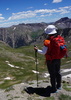
I parked about a half mile before the official trailhead, mainly because I knew the trail would be uphill right from the start, so I wanted to give myself some easy walking to loosen up my legs first. 19 degrees at the start but was comfortable in a long sleeve t-shirt thanks to the very light wind. I liked that this hike started above timberline, which is my preference for 14ers. Views are good from the start, and get better and better as you head uphill. Steady uphill as the trail headed south. Somewhat rocky, which was more noticeable on the return.

As the trail curved to the east, it leveled off for a while, then climbed more steeply up towards Sloan Lake. I passed at least eight ptarmigans in this section. At the junction for the lake, I headed left and climbed a little more up to about 13,000' before dropping about 50' and across a talus slope. The drop is less than it looks, but I knew I would feel it on the return. Once past the talus, the trail starts climbing steeply again, then some gentler switchbacks up to a saddle around 13,500' or so. It was fairly windy at the saddle and just above it. Great views in both directions.

It's a steep climb the rest up the way to the summit, where there were a handful of people and one dog resting. The summit itself is fairly small, but room to sit on the rocks, and excellent 360 degree views. I think all 14ers have great views from the top, but this one was probably top 5 for me. Rested for a while since there was no wind, then headed back down. Easy hike back down despite the steepness. Made a quick side trip to Sloan Lake on the way down. Passed a lot of hikers, including one woman who was hiking up with a young baby (like around 4 months by my guess) in a front carrier--kudos to her.

Very nice hike, and another one I know will kids will like. I wish the road was a little better, but that was the only mildly annoying part of the day.
 Named place
 Named place [ checklist ]
[ checklist ]  American Basin  Sloan Lake

water 1 out of 5water 2 out of 5water 3 out of 5water 4 out of 5 Sloan Lake 76-100% full 76-100% full
Lake looked nearly full.
_____________________
Stop crying and just go do the hike.
  1 archive
Oct 04 2020
avatar

 Guides 170
 Routes 148
 Photos 5,914
 Triplogs 2,097

48 male
 Joined Apr 12 2004
 Tucson, AZ
Handies PeakWest, CO
West, CO
Hiking avatar Oct 04 2020
PrestonSandsTriplogs 2,097
Hiking6.50 Miles 2,850 AEG
Hiking6.50 Miles
2,850 ft AEG
 no routesno photosets
1st trip
Linked   none no linked trail guides
Partners partners
ryan321
Colorado 14ers trip 2020, hike 1 of 3.

Having traveled from our campsite near Potato Lake (Purgatory) that morning, my brother Ryan and I took my 4Runner over the always-exciting, tire-chewing Cinnamon Pass, and then down the other side into American Basin. I parked partway up the trailhead road, and we set off on foot for Handies. The green vegetation of summer had given way to the browns of autumn, yet the mountain air and sunshine felt pretty nice for an October afternoon. The half dozen or so other hikers only slightly outnumbered the marmots we encountered, sunning themselves on a boulder. A few elusive pikas greeted us from the talus. We stopped to check out Sloan Lake, with its frigid blue-green water beneath a snow-smattered cliff face, before making the lung-taxing final ascent to the summit. This was my brother’s first 14k foot summit, and an exciting moment to share with him. After admiring the view and taking lots of photos, we began our descent as the wind howled and the sun sank close to the jagged western horizon. The sunset was amazing, as a red ball dipped below the ridge. The last couple of miles to the truck was by headlamp, with a number of reflective deer eyes catching the light. Back at the truck, we sat inside and enjoyed Mountain House dinners while watching the stars. Our goal for the night was a campsite near Lake City, and it was a long drive over rough roads before we were finally able to crawl into our tents.
_____________________
"…you never know when a hike might break out" -Jim Gaffigan
  1 archive
Sep 05 2019
avatar

 Guides 99
 Routes 1,484
 Photos 16,072
 Triplogs 1,374

male
 Joined Jan 07 2017
 Fountain Hills,
Handies PeakWest, CO
West, CO
Hiking avatar Sep 05 2019
DixieFlyerTriplogs 1,374
Hiking8.60 Miles 3,673 AEG
Hiking8.60 Miles   5 Hrs   47 Mns   2.00 mph
3,673 ft AEG   1 Hour   29 Mns Break
 
1st trip
Linked   linked  
Partners none no partners
This was the first of five 14ers that I hiked in four days in the amazingly beautiful San Juan Mountains in SW Colorado.

This one was the "alternate" route up to Handies via the Grizzly Gulch Trail.

The drive to the TH wasn't bad -- we were in a Wrangler and we parked next to an Outback; so a 4WD vehicle wasn't needed, but the drive is better with some decent clearance.

We saw 3 deer in the early part of the hike, but other than pikas and marmots, they were the only animals that I saw in the San Juans.

This was a gorgeous hike all the way to the summit, and at the summit the 360 degree views were awesome!
 Named place
 Named place [ checklist ]
[ checklist ]  Sloan Lake
wildflower observationwildflower observationwildflower observationwildflower observationwildflower observation
Wildflowers Observation Moderate
_____________________
Civilization is a nice place to visit but I wouldn't want to live there
 
Jul 12 2016
avatar

 Routes 30
 Triplogs 186

37 male
 Joined May 15 2015
 Tucson
Handies PeakWest, CO
West, CO
Hiking avatar Jul 12 2016
jrousoshammondTriplogs 186
Hiking7.94 Miles 3,674 AEG
Hiking7.94 Miles   5 Hrs   19 Mns   1.67 mph
3,674 ft AEG      33 Mns Break
 
no photosets
1st trip
Linked   none no linked trail guides
Partners none no partners
This was a re-attempt of a hike that was called off last year due to weather and a bum knee. I wouldn't mind trying it a third year in a row - it's one of my favorites, and aside from some slippery steep trail on the homestretch, it's one of the easiest 14ers (and the alternate route from American Basin is supposed to be even easier). When the trail leaves the trees and traces a stream toward the impressive east face of Handies, it makes for one of the most special stretches of trail I've been on.

Silver Creek/Grizzly Gulch TH is beautiful despite the constant ATV traffic it gets. There is ample space to camp at the TH and up the road.
_____________________
 
Jul 09 2016
avatar

 Photos 418
 Triplogs 169

female
 Joined Jul 22 2016
 Sedona, AZ
Handies PeakWest, CO
West, CO
Hiking avatar Jul 09 2016
xthineTriplogs 169
Hiking6.78 Miles 2,761 AEG
Hiking6.78 Miles   3 Hrs   45 Mns   1.94 mph
2,761 ft AEG      15 Mns Break
 no routesno photosets
1st trip
Linked   none no linked trail guides
Partners none no partners
First trip to Handie's and 1st 14er. :y:

Drove from Sedona to Ouray and did not get to town until midnight.

Started later than planned the next day. Rented a lifted 4 door Rubicon and the road to the trail head was tight!
Gorgeous scenery on the way to the trailhead. Made it without any issues in the 4 x 4. Cinnamon pass was also gorgeous. There were lots of Jeeps at the trail head and traffic was moderate. Most of the hikers were already on their way down by the time we got here at around 11. The forecast did not call for any rain or thunderstorms so we decided to proceed.

American basin is such a beautiful place, I was in awe every step of the way. So much greenery, wall to wall wildflowers, a gentle babbling stream and cool crisp mountain air.

At this point the highest I've ever been is Humphrey's, we questioned whether we would be able to make it to the summit having started so late.
We told ourselves we should at least try to get to 13,000 (highest I've ever been) and before we knew it..summit! Very gentle walk up to the top, plenty of room for traffic. Saw some kids and a few 4 legged friends, 1 trail runner. There was only one very short scree section to the top. Crossed a few snowfields without any issues.
There were only 2 other groups at the summit (took us about 2 hours up) one group was visiting from Flagstaff.
I'm glad this was my 1st 14er. Tricky to get to but well worth the effort!

Next time maybe Redcloud and Sunshine? :)
wildflower observationwildflower observationwildflower observationwildflower observationwildflower observation
Wildflowers Observation Substantial
_____________________
  3 archives
Sep 29 2015
avatar

 Triplogs 348

32 male
 Joined Oct 13 2012
 Tucson, AZ
Handies PeakWest, CO
West, CO
Hiking avatar Sep 29 2015
iborregoTriplogs 348
Hiking6.00 Miles 2,450 AEG
Hiking6.00 Miles
2,450 ft AEG
 no routesno photosets
1st trip
Linked   none no linked trail guides
Partners none no partners
_____________________
  1 archive
Jul 29 2015
avatar

 Guides 13
 Routes 38
 Photos 1,651
 Triplogs 577

60 male
 Joined Nov 15 2005
 Jackson, CA
Handies PeakWest, CO
West, CO
Hiking avatar Jul 29 2015
toddakTriplogs 577
Hiking10.50 Miles 3,500 AEG
Hiking10.50 Miles   6 Hrs      1.75 mph
3,500 ft AEG
 no routes
1st trip
Linked   linked  
Partners none no partners
Up the front side via Grizzly Gulch and then down the back side via American Basin, road walk back to the start. I thought the Grizzly Gulch side was the better scenery. Incredible wildflowers everywhere.
wildflower observationwildflower observationwildflower observationwildflower observationwildflower observation
Wildflowers Observation Extreme
_____________________
  1 archive
Aug 10 2013
avatar

 Triplogs 100

40 male
 Joined Jan 03 2011
 chandler, Az
Handies PeakWest, CO
West, CO
Hiking avatar Aug 10 2013
DBmoonerTriplogs 100
Hiking6.00 Miles 2,450 AEG
Hiking6.00 Miles   4 Hrs   5 Mns   1.47 mph
2,450 ft AEG
 no routesno photosets
1st trip
Linked   none no linked trail guides
Partners none no partners
this is the first 14er I was able to summit . Started the day with a clear sky and by the time we hit the summit the clouds started to roll in and with in 10 mins of being on the summit it started to snow , I wasn't very much and it melted as soon as it hit the ground but it still snowed in August :o :o . so we quickly hiked down the mountain to beat the thunder storm that was blowing in and we were able to get back to the truck be for the down poor began .
_____________________
 
Aug 23 2012
avatar

 Guides 93
 Routes 397
 Photos 4,984
 Triplogs 4,124

49 male
 Joined Jun 20 2003
 Tucson, AZ
Handies PeakWest, CO
West, CO
Hiking avatar Aug 23 2012
fricknaleyTriplogs 4,124
Hiking7.90 Miles 3,747 AEG
Hiking7.90 Miles
3,747 ft AEG
 
no photosets
1st trip
Linked   none no linked trail guides
Partners partners
PrestonSands
decided on handies peak from grizzly gulch for our grand finale. the forecast was downright bad but we figured we'd head out and try it...just see what happens. turn around if it got sketchy.

we started off in cloudy skies. started climbing steeply in the forested lower section of grizzly gulch and with the humidity i was just pouring sweat almost immediately. periodic breaks in the trees showed handies was currently hiding in the clouds. as we broke out of the forest for good we entered the wonderland of the upper grizzly gulch. climbing up to the ridge for the final ascent up to handies was very tough for me, but we could see that the weather was going to inexplicably clear for our summit attempt.

as we hit the summit brilliant sunlight and clear skies overhead, with wild drastic clouds out over the san juans produced unimaginable beauty and just amazing views. we were both pretty dumbfounded. before long ugly clouds were back and obviously building quickly so we bailed out and headed back. 5 minutes from the end the rain started but only lasted a few minutes (would rain again and again throughout the day). on the way there in the morning we saw mountain goats and on the way back we saw a cow moose and her baby :y:

probably the hike of the summer for me.

the second annual yeti road trip 2012 was another smashing success. thanks for driving Preston. awesome, AWESOME trip!!!!!
_____________________
hi
 
Sep 04 2010
avatar

 Routes 37
 Photos 2,160
 Triplogs 627

43 female
 Joined Mar 01 2010
 Phoenix, AZ
Handies PeakWest, CO
West, CO
Hiking avatar Sep 04 2010
juliachaosTriplogs 627
Hiking6.00 Miles 2,450 AEG
Hiking6.00 Miles   3 Hrs   28 Mns   1.73 mph
2,450 ft AEG
 
1st trip
Linked   none no linked trail guides
Partners none no partners
How I did on this hike pretty much defined the rest of the weekend for me. The original plan was to conquer five 14ers, but the altitude really got to me on this trip for the first time ever. Probably had something to do with leaving for CO directly after work and not getting enough sleep or time to acclimate. The roads going up to this one are pretty rough. I personally wouldn't want to be driving anything up there that wasn't high clearance/4WD, but there was a Toyota sedan parked up there which had to have gone over a stream right before the TH.

The trail itself is pretty straightforward. It starts climbing and doesn't stop until the top. I think there was only one portion where some elevation is lost, but it doesn't last long or drop too far. The top has some nice views of various 14ers. It was neat being up there that day because there were two couples who had an unexpected reunion after not having seen each other in years -- it was the first 14er for all of them, too. Lots of really friendly people out on the trail that day. There are also some other trails that connect in the area to some other hikes. I checked out Sloan Lake on the way back down and took a much-needed nap on its slabby shore. There was a couple who passed by who had apparently been hiking in the American Basin and along some of the ridges to the left of Handies. On the way out I met a man from my hometown who was in the area with his son. They had just done Wetterhorn that morning. Super cool.

Good hike, but it kicked my butt hardcore thanks to the elevation. Oh, if only I'd had one more day out there before attacking these routes, I'd have been a peakbagging machine this weekend! =P
 Flora
 Flora [ checklist ]
[ checklist ]  Avens
wildflower observationwildflower observationwildflower observationwildflower observationwildflower observation
Wildflowers Observation Isolated
_____________________
 
Aug 06 2008
avatar

 Guides 73
 Routes 176
 Photos 10,174
 Triplogs 2,324

46 male
 Joined Sep 08 2006
 
Handies PeakWest, CO
West, CO
Backpack avatar Aug 06 2008
JimTriplogs 2,324
Backpack13.50 Miles 6,150 AEG
Backpack13.50 Miles   8 Hrs   30 Mns   1.59 mph
6,150 ft AEG
 no routes
1st trip
Linked   none no linked trail guides
Partners none no partners
For the culmination of my trip I decided to do Handies Peak (14,048') as an overnight trip with my backpack. It was actually not that hard to do and was really fun. I started at the Grizzly Gulch trailhead. My civic made it there without any problems and I didn't bottom out, despite the nature of the shelf road. I packed up the trail (with what I estimate to be my 35 to 40 pound pack) to Handies Peak and got to the summit in about 3 and 1/2 hours. I was tired and really happy to be there. I then went down to Sloan Lake at the upper end of the American Basin and made my camp. I spent the night at what is now my new record, 12,920' above mean sea level. It was not a bad night and I had no problems with the altitude. The only real problem was that I was kept awake by the heavy rain pounding on my tent, and the temperature was higher than normal at night because of the rain so I was hot at times. Still, I enjoyed it.

The next morning I hiked down to the American Basin trailhead and back up to my camp so that I could say I did both trailheads, and I wanted to see the basin. I broke camp and put my pack back on and headed back up Handies. I crested and then descended back into the Grizzly Gulch side and on to my car. Back in Lake City I enjoyed a $10.95 Buffalo Burger at the Packer Bar. They definetly do know all the customers who frequent it.

I started on the 6th and finished on the 7th. The time is for packing/ hiking only. My mileage and elevation are higher than the Dex because I did both trail heads and summited twice.
_____________________
🍭
 
Jul 24 2005
avatar

 Guides 1
 Routes 136
 Photos 22,415
 Triplogs 1,041

77 male
 Joined Feb 28 2003
 Tucson, AZ
Handies PeakWest, CO
West, CO
Hiking avatar Jul 24 2005
rwstormTriplogs 1,041
Hiking10.00 Miles 4,700 AEG
Hiking10.00 Miles
4,700 ft AEG
 no routes
1st trip
Linked   linked  
Partners none no partners
We did the hike to the peak via the Grouse Gulch route from near Animas Forks, since we were camping along Mineral Creek Road near Silverton and didn't want to hassle with driving over Cinnamon Pass. A beautiful and pretty mellow hike to this Fourteener. We kept a good pace all the way up. The reward: the views from the peak are really superb. :)

The only glitch for me was that my intermittent Afib kicked in on the way down from the peak. It doesn't happen often on hikes, but when it does it means reduced stamina. And of course being this high up, I knew that 600 foot uphill part from the trail junction to the pass at 13,020 was going to be tough. :sweat: It was, and it took me forever to reach that spot. By then I had a throbbing headache, was nauseous and totally fatigued. I took an Ibuprofen and laid down on the ground for about 20-30 minutes, while my hiking partners patiently waited. I finally started feeling better, especially knowing the remainder of the hike was downhill. By the time we reached the vehicles at the Animas River, I was feeling just fine. :D
wildflower observationwildflower observationwildflower observationwildflower observationwildflower observation
Wildflowers Observation Moderate
_____________________
 
Aug 15 1992
avatar

 Guides 9
 Photos 134
 Triplogs 75

48 male
 Joined May 01 2002
 Denver, CO
Handies PeakWest, CO
West, CO
Hiking avatar Aug 15 1992
MtnGeekTriplogs 75
Hiking6.00 Miles 3,050 AEG
Hiking6.00 Miles
3,050 ft AEG
 no routesno photosets
1st trip
Linked   none no linked trail guides
Partners none no partners
1st 14er, hiked it when I was 15. Hiked Grizzly Gulch.
_____________________
Mountains are there to be hiked!
 
average hiking speed 1.68 mph

WARNING! Hiking and outdoor related sports can be dangerous. Be responsible and prepare for the trip. Study the area you are entering and plan accordingly. Dress for the current and unexpected weather changes. Take plenty of water. Never go alone. Make an itinerary with your plan(s), route(s), destination(s) and expected return time. Give your itinerary to trusted family and/or friends.

helpcommentissue

end of page marker