username
X
password
register
for free!
help
ArticlesGuidesRoutes
 
Photosets
 
 Comments
triplogs   photosets   labels comments more
White Pocket - 9 members in 22 triplogs have rated this an average 4.4 ( 1 to 5 best )
1, 2  Next
22 triplogs
login for filter options
Apr 05 2025
avatar

 Routes 43
 Photos 2,133
 Triplogs 82

female
 Joined Dec 09 2024
 
White PocketNorthwest, AZ
Northwest, AZ
Hiking avatar Apr 05 2025
DesertNymphTriplogs 82
Hiking3.30 Miles 800 AEG
Hiking3.30 Miles   2 Hrs   15 Mns   1.47 mph
800 ft AEG
 no routes
1st trip
Linked   linked  
Partners partners
Vashti
Looking back at old photos and their exif data, the last time I visited White Pocket was nearly 11 years ago to the day. It's been a while since I've been north of Flagstaff...this trip reminded me of the vast landscapes that I have visited and adore spending time in up in northern Arizona and Southern Utah, even with all the sand-walking (and associated accumulation of grit in all of my gear).

I had my misgivings the week before the trip while checking the forecast - a combination of anxiety over the weather and a group of folk I haven't met or interacted with before. I found myself constantly refreshing the national weather service page for the area and checking the radar. We enjoyed some pretty spectacular cloud displays on the drive up and exited the car to a brief drizzle when we stopped for lunch to meet up with the rest of the crew at Marble Canyon. After dodging what appeared to be the worst of the clouds as we drove House Rock Valley Road, we were dealt a smattering of graupel at camp on arrival - then the skies cleared and we had good, if cool, weather for the remainder of the weekend.

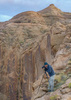
After getting our camping gear set up, we popped over to Double Barrel/House Rock Valley Arch to stretch our legs after the drive up. Round trip was a sandy 2-mile walk following the fenceline from the parking area to a break near the escarpment where the arches are located. Some of the unique geology in the area (moqui balls) set the group's humor for the weekend with ongoing jokes about balls running for the duration of the trip 🤭.

After a leisurely morning defrosting ourselves from the sub-freezing temps, we piled into a pair of well outfitted 4Runners and headed off for White Pocket (and after that, a tour of the plateau). It was evident that White Pocket is seeing a lot more visitation than it has in years past. The road is wider than I recall in many places, and while still sandy, doesn't seem to be the powdery sugary sand that I remembered - though that could have been due to the combination of the increased traffic and the recent precipitation. We arrived at the parking area to discover most of the spots along the fence line occupied by a combination of 4Runners, various Jeeps, an occasional truck and a smattering of side by sides. With the number of visitors, I'm surprised a vault toilet hasn't yet been installed.

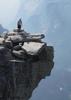
Heading through the fence, a 0.3 mile sandy track brings you to the whitepocket formation area where time was spent wandering hither and yon. While there were a number of other people present, the nature of the area encourages individual exploration and the groups tend to disperse, allowing for the illusion of solitude as long as you don't stay in one spot for too long.

After wandering the petrified sand dunes and taking plenty of photos that will not do the place justice, we returned to the vehicles and continued on a tour of the plateau, checking out some additional areas before calling it a day and returning to our camp.

I'm glad my misgivings about the weather didn't keep me away - it was a fun trip, filled with gorgeous landscapes and good company. If I head back up that way again, I'll want to aim for midweek, given my preference for solitude 😆 though I'll have to find someone I can ride with since my car definitely is not suitable!
wildflower observationwildflower observationwildflower observationwildflower observationwildflower observation
Wildflowers Observation Isolated
Manzanita were blooming, and one lonely milkvetch was spotted while wandering a nearby sandy wash.
_____________________
Happier when hiking....I may not move fast (and I'm often distracted by wildflowers), but I'll get there eventually 😆
 
Apr 05 2025
avatar

 Guides 17
 Routes 297
 Photos 1,808
 Triplogs 276

female
 Joined Mar 11 2002
 Gilbert, AZ
White PocketNorthwest, AZ
Northwest, AZ
Hiking avatar Apr 05 2025
VashtiTriplogs 276
Hiking3.27 Miles 550 AEG
Hiking3.27 Miles   2 Hrs   16 Mns   1.54 mph
550 ft AEG      9 Mns Break
 
1st trip
Linked   none no linked trail guides
Partners partners
DesertNymph
Route Scout Route Recorded  on Route Scout | Pop | Map | Popup | MapDEX
Headed out to the White Pocket area on Friday afternoon despite ominous weather reports. In fear of muddy roads and fierce wind, we chose to camp in a turnout just past the Trailhead for double barrel arch on Pine Tree Road (Blm 1017 road) instead of nearer to white Pocket. We also wanted some trees as a wind block. It turns out the weather gods were with us, though, and despite it being very cold at night, we avoided all precipitation except the rain on our drive in.

As expected, the drive to white Pocket was sandy, but very well used. I went with 2 other people who had each last had been to the Trailhead about 10 years ago. They said the road is much changed due to the increased use. That formerly it was a double track with very fine sand. Now the road is very wide in places, and while sandy, it is not the fine sand that you see on the way to hole in the rock and beyond. Also, the center can be quite high due to the deep ruts. The first parking lot at white Pocket is very large. I counted 20 trucks at the Trailhead mid morning when we arrived and about that same number when we departed a few hours later. It was a Jeep and Forerunner party with a few trucks sprinkled in. People are coming and going, and there are a number of tours, too. For less crowding, don't come on a weekend! The second parking area is considerably smaller and had about 5 vehicles in it.

Despite all the people, white Pocket is a big area, and it is possible to get some solitude here and there. The White Pocket area is beautiful! I've been wanting to go there for such a long time but didn't have the correct vehicle to get me there. It turns out that I still don't... I need to replace my stock tires with off road appropriate tires. 4wd and high clearance is not enough. Given my slipping and sliding on the way to our campsite, I left my jeep at the campsite, and we took 2 Forerunners with off road tires to white Pocket and beyond. 😁. I think my jeep would have made it just fine from house rock valley road to Pine tree pocket ranch. Pine Tree road/Blm 1017 is in good shape. It is only on Blm roads 1087 and 1086 where the severe sandiness starts.

I really enjoyed all the colors and rock formations in white Pocket. What a magical place! 😍❤️ Next time I will come back mid week in hopes of more solitude and less instagram staging!!

We ended up having perfect weather with sun, cooler temperatures, and not too much wind!
_____________________
:D
  3 archives
Feb 16 2025
avatar

 Guides 3
 Routes 633
 Photos 8,249
 Triplogs 605

54 male
 Joined Apr 13 2011
 Gilbert, AZ
White PocketNorthwest, AZ
Northwest, AZ
Hiking avatar Feb 16 2025
ddgrunningTriplogs 605
Hiking3.05 Miles 546 AEG
Hiking3.05 Miles   2 Hrs   55 Mns   1.44 mph
546 ft AEG      48 Mns Break
 
Linked   none no linked trail guides
Partners none no partners
Route Scout Route Recorded  on Route Scout | Pop | Map | Popup | MapDEX
V-Day Trip -- Part 3

The overnight camp was, as expected, cold! We accidently left a gallon jug of water out overnight and woke up to in frozen .... Luckily, we had more water in the Jeep and eked out breakfast and some hot chocolate.

Then we high-tailed it over to White Pocket to catch the sunrise.

In contrast to the evening before, we enjoyed a lot of solitude--only two other photographers out in the morning, and they left shortly after the sunrise. From then on, we had the place to ourselves.

The wow factor of this place is very high. So much unique geology. My favorite part of the trip. Glad the drive is a barrier to entry.
_____________________
 
Feb 15 2025
avatar

 Guides 3
 Routes 633
 Photos 8,249
 Triplogs 605

54 male
 Joined Apr 13 2011
 Gilbert, AZ
White PocketNorthwest, AZ
Northwest, AZ
Hiking avatar Feb 15 2025
ddgrunningTriplogs 605
Hiking1.46 Miles 179 AEG
Hiking1.46 Miles      57 Mns   1.86 mph
179 ft AEG      10 Mns Break
 
Linked   none no linked trail guides
Partners none no partners
Route Scout Route Recorded  on Route Scout | Pop | Map | Popup | MapDEX
V-Day Trip part 2

After setting up camp at a great location near the WP trailhead, we headed over to WP for a preview of our planned explore the following morning and to catch the sunset.

No permit required here, and the parking area reflected it. Between SxSs and 4X4s, there were 15+ cars at the TH in the late afternoon.

But it was quickly apparent why this is a popular area. Wow! We enjoyed the sunset and then returned to camp excited to explore in the morning.
_____________________
 
Apr 26 2024
avatar

 Guides 94
 Routes 840
 Photos 22,055
 Triplogs 1,993

52 male
 Joined Sep 18 2002
 Tempe, AZ
White PocketNorthwest, AZ
Northwest, AZ
Hiking avatar Apr 26 2024
chumleyTriplogs 1,993
Hiking5.46 Miles 885 AEG
Hiking5.46 Miles   2 Hrs      2.73 mph
885 ft AEG
 no routes
Linked   none no linked trail guides
Partners partners
Jonnybackpack
When you're in Paris, you gotta visit the Eiffel Tower, even if it's a little touristy. Some things are iconic for a reason.
_____________________
I'm not sure what my spirit animal is, but I'm confident it has rabies.
  1 archive
Sep 22 2023
avatar

 Guides 94
 Routes 840
 Photos 22,055
 Triplogs 1,993

52 male
 Joined Sep 18 2002
 Tempe, AZ
White PocketNorthwest, AZ
Northwest, AZ
Hiking avatar Sep 22 2023
chumleyTriplogs 1,993
Hiking1.30 Miles 153 AEG
Hiking1.30 Miles      55 Mns   2.00 mph
153 ft AEG      16 Mns Break
 no routes
Linked   none no linked trail guides
Partners none no partners
The drive was the real adventure. Once our caravan got on track, it was pretty late and had become flat and overcast. As we made the most of it, the sky exploded in a brilliant sunset. I'd like to spend a bit more time wandering around here with more daylight. Next time...
 Named place
 Named place [ checklist ]
[ checklist ]  White Pocket
_____________________
I'm not sure what my spirit animal is, but I'm confident it has rabies.
 
Apr 25 2023
avatar

 Guides 4
 Routes 205
 Photos 9,282
 Triplogs 526

72 male
 Joined Apr 06 2005
 Phoenix, AZ
N. Arizona Spring Break 2023, AZ 
N. Arizona Spring Break 2023, AZ
 
Hiking avatar Apr 25 2023
HansenazTriplogs 526
Hiking6.00 Miles
Hiking6.00 Miles
 no routes
1st trip
A few of my occasional Happy Hour friends (we all worked together in the '80s) are amateur photographers and one proposed a trip to White Pocket, a return for him. The four of us booked two nights at Cliff Dwellers Lodge near Marble Canyon and planned some other stops along the way.

Wupatki NM: We drove through on the way up and headed to a corner I've been wanting to see. We stopped at Wukoki Pueblo which is off the main road and nice to visit. Then we continued along to Black Falls Crossing which I think is the next one downstream from Grand Falls. Lots of water there right now, but no falls.

White Pocket: Next day we met our ride at the south end of House Rock Rd (we knew that road is difficult so a guide was hired) and bumped our way up to the WP parking area. Road conditions were pretty good and private parties slightly outnumbered guided ones. I did see one all-wheel drive car (a Honda Passport) had made it to the end. Of course it's a fantastic place to walk around and a lot of fun. Scenic as heck but our mid-day experience I'm sure can't compare to the low sun pictures that can be found on HAZ.

West Bench Pueblo: I had noticed this place in the WP vicinity posted by @PaleoRob. It was a short detour for us and the road leads right to it. Pretty standard ruin and pottery scatter at the main location - I'm sure there's more to find if you look around.

Upper Soap Creek: I noticed a HAZ post by @ddgrunning leaving from Cliff Dwellers and heading up the canyon. So after WP my friends drove down to Lee's Ferry to take pictures and I walked up the canyon about a mile. A leg stretcher, not too interesting in this section.

Coal Mine Canyon: On the way home the next day we went to CMC. Several of us had been there before and knew it was a tricky place because the Navajo authorities didn't seem to want visitors there. Well things have changed. On our way up the first day, we stopped in Cameron to see if we could get a permit and were told we didn't need one (surprise #1). When we actually arrived there we found a couple Navajo surveyors studying the area (a subsidence concern associated with mining) and they "implied" the area was opening up (surprise #2). And as we walked around "development signs" were obvious, including simple hand rails making access safer and more organized (surprise #3). Interesting.

After walking around this main site we drove to another location we'd heard about (and I won't describe it here) which gave some alternate cool views of this big canyon complex.

Successful trip!
_____________________
  2 archives
Oct 27 2022
avatar

 Routes 255
 Photos 1,071
 Triplogs 245

68 male
 Joined Feb 10 2008
 Kent,wa
White PocketNorthwest, AZ
Northwest, AZ
Hiking avatar Oct 27 2022
fdv75Triplogs 245
Hiking1.38 Miles 269 AEG
Hiking1.38 Miles   1 Hour   12 Mns   1.53 mph
269 ft AEG      18 Mns Break
 
no photosets
1st trip
Linked   none no linked trail guides
Partners none no partners
Route Scout Route Recorded  on Route Scout | Pop | Map | Popup | MapDEX
Very unique rock.
_____________________
 
Apr 02 2021
avatar

 Routes 175
 Photos 2,335
 Triplogs 191

44 female
 Joined Jan 21 2019
 Pine, AZ
White PocketNorthwest, AZ
Northwest, AZ
Hiking avatar Apr 02 2021
jillyonanadventureTriplogs 191
Hiking1.15 Miles 139 AEG
Hiking1.15 Miles   1 Hour   10 Mns   1.35 mph
139 ft AEG      19 Mns Break
 
1st trip
Linked   none no linked trail guides
Partners partners
jharvey33
Route Scout Route Recorded  on Route Scout | Pop | Map | Popup | MapDEX
White Pocket had been on my list for a while and it seemed like a perfect opportunity to test out Tessa in the sand! James said the road appeared to be in better condition than he’d seen it previously, but it was definitely still a tricky drive. The sand is quite slippery and it’s fine as long as you can keep moving. We would stop and wait when we got too close to other vehicles to avoid getting stuck. There was a vehicle in front of us (Large SUV) and it was sliding everywhere having a hard time getting any traction. 4 wheel drive and the sand/mud button on the 4Runner helped a lot. James handled this road like a pro as it was a bit too intimidating for me.

Anyway, the hike is more like a walk wherever you want to go. White Pocket is big, but it was somewhat smaller than I expected with the prettiest rocks/striations concentrated in a few areas. There were a good amount of people there, but you could still get a bit of privacy here and there. It was very hot there on a day without many clouds! Definitely glad I saw it, but wasn’t blown away 🤷‍♀️
_____________________
Restless between adventures...
  1 archive
Mar 27 2021
avatar

 Routes 386
 Photos 49
 Triplogs 792

43 female
 Joined Jun 23 2015
 Phoenix, AZ
White PocketNorthwest, AZ
Northwest, AZ
Hiking avatar Mar 27 2021
emilystardustTriplogs 792
Hiking1.70 Miles 200 AEG
Hiking1.70 Miles
200 ft AEG
 no routesno photosets
1st trip
Linked   none no linked trail guides
Partners none no partners
_____________________
 
Nov 28 2020
avatar

 Photos 5
 Triplogs 1,041

36 female
 Joined Oct 04 2012
 Phoenix, AZ
White PocketNorthwest, AZ
Northwest, AZ
Hiking avatar Nov 28 2020
WaitingForRainTriplogs 1,041
Hiking1.70 Miles 200 AEG
Hiking1.70 Miles
200 ft AEG
 no routesno photosets
1st trip
Linked   none no linked trail guides
Partners none no partners
_____________________
 
Sep 15 2018
avatar

 Photos 104
 Triplogs 47

32 female
 Joined Oct 17 2016
 Phoenix
White PocketNorthwest, AZ
Northwest, AZ
Hiking avatar Sep 15 2018
peculiargalexyTriplogs 47
Hiking1.70 Miles 200 AEG
Hiking1.70 Miles
200 ft AEG
 no routesno photosets
1st trip
Linked   none no linked trail guides
Partners none no partners
Feeling ambitious over a holiday weekend I headed to northern Arizona with the pups. Wanted to let them play in the river so we headed to Lees Ferry first- my absolute favorite place on this planet. Then feeling a bit intimidated by the reports of sandy roads, I headed to White Pocket. As I was driving between the Kaibab plateau and the Vermillion Cliffs, a storm was bearing down on me. One half was sunny, the other rumbled ominously with thunder. And I was following google maps. Bad idea.

The turn off had be go halfway up the plateau and immediately enter some sketch territory. Almost lost my GPS after I got off track but managed to find it and make my way back to the correct road. As I was pulling out some dude in a pickup comes bumbling up this beautifully smooth dirt road and it made me angry. Because I had spent all that time lost and slightly terrified while the thunderstorm hit and it hailed and was cold and intense and here this dude comes bumbling along on the correct route. But makes for a good story right? :lol:

Found the turn off for the sandy road easily and switched to four high. Felt the sand catching my tires at times but made it through no problem and enjoyed the new challenge. After the roads I had just went through this was a breeze. Made it to the parking lot and was loving the mountains surrounding it and marveling at this giant plateau with these teeny little rock formations that someone just had to find up here. The dogs loved exploring it and it was a lot of fun to see the formations. Such a beautiful place and one of my new favorites, along with Lees Ferry. I love seeing the geology connect and understanding how the regions are formed.

Need trail info? PM me.
_____________________
 
May 07 2017
avatar

 Photos 7
 Triplogs 2

male
 Joined Apr 11 2019
 Chandler, AZ
White PocketNorthwest, AZ
Northwest, AZ
Hiking avatar May 07 2017
DarrellLFosterPhotTriplogs 2
Hiking1.70 Miles 200 AEG
Hiking1.70 Miles
200 ft AEG
 no routes
1st trip
Linked   none no linked trail guides
Partners none no partners
Love this place! Here are a few images from past visits.
_____________________
Darrell L Foster
https://www.darrelllfosterphotography.com/
 
Oct 05 2016
avatar

 Photos 326
 Triplogs 124

71 female
 Joined Jan 04 2014
 Phoenix, AZ
White PocketNorthwest, AZ
Northwest, AZ
Hiking avatar Oct 05 2016
AZBeaverTriplogs 124
Hiking2.30 Miles 500 AEG
Hiking2.30 Miles
500 ft AEG
 no routesno photosets
1st trip
Linked   none no linked trail guides
Partners partners
AZWanderingBear
After Cottonwood Cove, our convoy passed Poverty Draw and it's ramshackle and unused ranch ruins. We slalomed our vehicles downhill in the curving sand road to the ample parking lot at White Pocket. The short walk to the edge of the White Pocket formation is akin to falling down the rabbit hole into another world, an amazing world.

After all the red sandstone of the morning, the bleached white cauliflower formations that make White Pocket so unique was almost an assault on our senses. It was so...different...unexpected....weird. I know that the hematite in the red sandstone has been leached from the white rocks of the White Pocket. Actually to an extraordinary degree to the point that low areas are collections of Moqui Marbles, the iron minerals waterborne from the stone forming iron marbles by congealing around a single grain of sand. Many were over an inch in length resembling rusty red almonds on steroids. The blood of the red rocks had run out and reformed into iron nodules. But the shape of the white sandstone, not layered like the other rock around it, instead taking on the look of a head of cauliflower or perhaps the surface of a brain with the skull stripped away remains a mystery to me and apparently to geologists. There are theories, but no one is certain how the White Pockets came to be.

Not that everything is white. The areas where the white met the deep reds in steep uplifts only to swirl down in waves that dropped into the earth were dizzying and delightful. We wandered fairly aimlessly about, drawn from one rocky beauty to another, ceasing to wonder how and why choosing to just enjoy the what of it all.

The shadows were getting long and we had many miles of sandy road to travel back to our camp and dinner at Stateline. We dropped down the southern dunes to take in the petroglyph panel and the pottery sherds and corn cobs that remain in the huge alcove to the south. I wonder what the folks who made those pots and shelled that corn thought of this place?

We took the longer, but easier road to the south past the still working ranch passing a couple of cowboys also headed in for the evening. It had been a long day, so dinner was quick, the conversations short but appreciative of the day's experience.

Our trip was nearing its terminus. White Pocket was an apex point of the adventure we'd begun 9 days earlier.
_____________________
 
Oct 05 2016
avatar

 Guides 27
 Routes 61
 Photos 2,620
 Triplogs 700

69 male
 Joined Jan 23 2008
 Phoenix, AZ
White PocketNorthwest, AZ
Northwest, AZ
Hiking avatar Oct 05 2016
AZWanderingBearTriplogs 700
Hiking2.30 Miles 500 AEG
Hiking2.30 Miles
500 ft AEG
 no routes
1st trip
Linked   none no linked trail guides
Partners partners
AZBeaver
After Cottonwood Cove, our convoy passed Poverty Draw and it's ramshackle and unused ranch ruins. We slalomed our vehicles downhill in the curving sand road to the ample parking lot at White Pocket. The short walk to the edge of the White Pocket formation is akin to falling down the rabbit hole into another world, an amazing world.

After all the red sandstone of the morning, the bleached white cauliflower formations that make White Pocket so unique was almost an assault on our senses. It was so...different...unexpected....weird. I know that the hematite in the red sandstone has been leached from the white rocks of the White Pocket. Actually to an extraordinary degree to the point that low areas are collections of Moqui Marbles, the iron minerals waterborne from the stone forming iron marbles by congealing around a single grain of sand. Many were over an inch in length resembling rusty red almonds on steroids. The blood of the red rocks had run out and reformed into iron nodules. But the shape of the white sandstone, not layered like the other rock around it, instead taking on the look of a head of cauliflower or perhaps the surface of a brain with the skull stripped away remains a mystery to me and apparently to geologists. There are theories, but no one is certain how the White Pockets came to be.

Not that everything is white. The areas where the white met the deep reds in steep uplifts only to swirl down in waves that dropped into the earth were dizzying and delightful. We wandered fairly aimlessly about, drawn from one rocky beauty to another, ceasing to wonder how and why choosing to just enjoy the what of it all.

The shadows were getting long and we had many miles of sandy road to travel back to our camp and dinner at Stateline. We dropped down the southern dunes to take in the petroglyph panel and the pottery sherds and corn cobs that remain in the huge alcove to the south. I wonder what the folks who made those pots and shelled that corn thought of this place?

We took the longer, but easier road to the south past the still working ranch passing a couple of cowboys also headed in for the evening. It had been a long day, so dinner was quick, the conversations short but appreciative of the day's experience.

Our trip was nearing its terminus. White Pocket was an apex point of the adventure we'd begun 9 days earlier.
_____________________
All you have is your fire...
And the place you need to reach
  5 archives
May 12 2016
avatar

 Guides 100
 Routes 63
 Photos 2,548
 Triplogs 184

76 male
 Joined Nov 21 2015
 Grand Junction,
White PocketNorthwest, AZ
Northwest, AZ
Hiking avatar May 12 2016
Steph_and_BlakeTriplogs 184
Hiking4.00 Miles 200 AEG
Hiking4.00 Miles   5 Hrs      1.00 mph
200 ft AEG   1 Hour    Break
 no routesno photosets
1st trip
Linked   none no linked trail guides
Partners none no partners
We learned of the White Pocket area after I spoke to a ranger and asked the innocuous question : "Is there anything to see up on the high plateau to the east of House Rock Road?". We'd driven up and down that road numerous times and always wondered if there was anything up there besides cows. The ranger replied "Well, there's White Pocket, but I wouldn't advise you to drive out there. There's really deep sand and you'll get stuck." Hhmmmmmm...After seeing photos of the area we were on a mission! I finally got a different ranger to help us sort out the best driving route (which you can find on numerous posts on the internet). And, again, we were advised not to drive out lest we get stuck. We aired down the tires and enjoyed the ride out. However, I must say that you could get in quite a pickle if you're not experienced with driving in sand. And there were some rutted areas that warrants high clearance. Further, the signage wasn't good, so I strongly advise having a GPS driving route to follow. And extra water. And extra gas. And extra food. A good map. Satellite communications. Then enjoy!

We camped just south of the parking lot and had the place entirely to ourselves except for a few professional photographers.
The next morning we hiked out to the "formations" and meandered around for hours. I really don't know how to describe the area. It's unlike anything we've ever seen. Best to just look at the photos. Mine do a disservice to the area, so Google "White Pocket" and click on "images".
_____________________
Stephanie and Blake Barnard
  5 archives
Oct 02 2015
avatar

 Photos 99
 Triplogs 872

male
 Joined Mar 18 2012
 Goodyear, AZ
White PocketNorthwest, AZ
Northwest, AZ
Hiking avatar Oct 02 2015
MikeSTriplogs 872
Hiking1.40 Miles 100 AEG
Hiking1.40 Miles   1 Hour      1.40 mph
100 ft AEG
 no routesno photosets
1st trip
Linked   none no linked trail guides
Partners none no partners
On the way up to St. George, we decided to make it fun both ways so on the way up we went off roading (just got a new Tacoma) through the Vermilion Cliffs area. Drove out to White Pocket and explored the area. I will post the video link below as well as in the next write up about Buckskin Gulch.

https://youtu.be/PE ... 5MXk
_____________________
Subscribe to my adventure videos at: [ youtube video ]

Follow my adventures on Instagram at: adventures_az
 
Sep 19 2015
avatar

 Routes 1
 Photos 29,248
 Triplogs 1,448

45 female
 Joined Jan 18 2011
 In the Wild
White PocketNorthwest, AZ
Northwest, AZ
Hiking avatar Sep 19 2015
LucyanTriplogs 1,448
Hiking1.70 Miles 200 AEG
Hiking1.70 Miles
200 ft AEG
 no routes
1st trip
Linked   none no linked trail guides
Partners none no partners
_____________________
 
Mar 08 2015
avatar

 Routes 3
 Photos 92
 Triplogs 1

67 male
 Joined Sep 12 2007
 Chandler, AZ
White PocketNorthwest, AZ
Northwest, AZ
Hiking avatar Mar 08 2015
LowellTriplogs 1
Hiking1.70 Miles 200 AEG
Hiking1.70 Miles
200 ft AEG
 no routes
1st trip
Linked   none no linked trail guides
Partners none no partners
Sandy roads were frozen when we drove in early on Sunday so it was an easy drive in. Didn't leave until Monday afternoon and the sand had started to thaw and dry. We occasionally bogged down a bit, but still didn't get stuck.

Loved this place and hated to leave it. Even with a full moon the stars were incredible. Planning to go back but on a new moon.

From the topos, it looks like the confluence of Paria Canyon and Buckskin Gulch are about 4 miles away. Wondering if any HAZ folks have ever checked it out and what this confluence looks like from the rim.
_____________________
 
Oct 10 2013
avatar

 Routes 16
 Photos 921
 Triplogs 41

male
 Joined Jan 22 2007
 Mesa, AZ
White PocketNorthwest, AZ
Northwest, AZ
Hiking avatar Oct 10 2013
evanshikerTriplogs 41
Hiking1.70 Miles 200 AEG
Hiking1.70 Miles
200 ft AEG
 
1st trip
Linked   none no linked trail guides
Partners none no partners
Made my second trip to this fascinating place last Thursday. Last time we were here in July it was at least 100F and, although we had nice clouds, no one wanted to stay to capture the place in the late-day sun. It was too hot for most of the party.

This time we started at 6 am from Mesa, drove through snow and slick roads just south of Flag and ate lunch at a place along 89A after the Navajo bridge. We went with the intent of capturing late sun and clouds. This time, it had to be in the 40F's and with stong winds - and a little too many clouds. In fact, the clouds built up on the western horizon so much that it cut off good light way earlier than we had desired. But we did capture a little of what we wanted if we were willing to wait for those short periods when the sun broke through. But there was much that we didn't get to.

We had planned on doing Wire Pass Trail on Friday and then driving on to Canyon de Chelly, where we had arranged a guide to take along on a 4W outing up Canyon del Muerto on Saturday. So we couldn't really try to capture more at White Pocket the day after we had gone in. But we'll be back.
_____________________
To plunder, to slaughter, to steal, these things they misname empire; and where they make a wilderness, they call it peace. -- Publius Cornelius Tacitus (56 AD – 117 AD)
 
average hiking speed 1.63 mph
1, 2  Next

WARNING! Hiking and outdoor related sports can be dangerous. Be responsible and prepare for the trip. Study the area you are entering and plan accordingly. Dress for the current and unexpected weather changes. Take plenty of water. Never go alone. Make an itinerary with your plan(s), route(s), destination(s) and expected return time. Give your itinerary to trusted family and/or friends.

helpcommentissue

end of page marker