username
X
password
register
for free!
help
ArticlesGuidesRoutes
 
Photosets
 
 Comments
triplogs   photosets   labels comments more
Gibson Canyon Trail #308 - 3 members in 11 triplogs have rated this an average 3.7 ( 1 to 5 best )
11 triplogs
login for filter options
Jan 14 2025
avatar

 Guides 4
 Photos 4,732
 Triplogs 2,607

55 male
 Joined Sep 29 2004
 Small Town USA
Gibson Canyon Trail #308Tucson, AZ
Tucson, AZ
Hiking avatar Jan 14 2025
SkyIslander18Triplogs 2,607
Hiking7.00 Miles 1,400 AEG
Hiking7.00 Miles
1,400 ft AEG
 no routes
Linked   linked  
Partners partners
AddSanz
It's been 8 years, haven't been up the canyon portion since the Frye Fire of 2017
First made a quick stop on the drive in at the petroglyphs.

The hike up through the lower winter grasses was beautiful!
S canyon higher up also beautiful with a few pools along the creek bed.
We then took Round the Mountain trail south towards Marijilda.
The views up Graham had little snow, but were still wonderful!
We rested at the first big gorge by the creek, had lunch then returned back.
Both trails have been cleaned up and were in perfect condition.
The whole area has recovered well from the fire and except for the lower prickly pears, you could almost not tell a fire ran through this canyon ... happy dance!
Great scenic backyard hike with my good buddy (her first time up Gibson).
I really love this area!
:D

water 1 out of 5water 2 out of 5water less than maxwater less than max Gibson Creek Light flow Light flow

water 1 out of 5water less than maxwater less than maxwater less than max S Canyon Pools to trickle Pools to trickle
_____________________
https://www.instagram.com/skyislander22/
  2 archives
Apr 02 2023
avatar

 Routes 2
 Photos 99
 Triplogs 24

male
 Joined Mar 29 2022
 Tucson, AZ
Gibson Canyon Trail #308Tucson, AZ
Tucson, AZ
Mtn Biking avatar Apr 02 2023
gordee151Triplogs 24
Mtn Biking5.00 Miles 1,100 AEG
Mtn Biking5.00 Miles
1,100 ft AEG
 no routes
1st trip
Linked   none no linked trail guides
Partners none no partners
Ride Report from April 2, 2023.
I rode from the creek crossing on forest rd 57 to about the 1.5 mile mark up on Gibson Trail. I turned around just before the trail begins to drop into the canyon before it's begins to climb again toward Round the Mountain Trail. The trail is definitely grassy and seldom used BUT relative to many of Mt Graham's trail it's in decent shape. For mountain bikes it's certainly a mix of hike a bike and pedaling up. There are some deep rock wate rbar type steps. Also sections where the trail squeezes narrowing through some rock.

However, Gibson Canyon looking up at the high peaks is insanely beautiful and it's incredibly peaceful out there. Even more challenging is finding Forest Rd 57 road off of Swift Hwy 366 to get to the trailhead. Even then in a passenger car the 2 miles or so of road out to the creek creek crossing is slow going. The road is rougher after the creek so it just seems easier to pedal the extra mile in to the trailhead. I'll be curious to try this as a loop starting at Noon Creek on RTM to Gibson and back road #57 and up the Swift Hwy.

The Forest Service has plans to re-open Round the Mountain toward Deadmans, Frye Mesa and on up to Columbine. Trail crews should begin working late Summer 2023.

Want to get involved with trail work?
↓ See my signature below ↓
_____________________
Sonoran Desert Mountain Bicyclists
Mt Graham Volunteer Trail Work Coordinator
Want to volunteer? Email: communications@sdmb.org
Instagram @sdmb_mtb
  1 archive
Mar 08 2022
avatar

 Guides 187
 Routes 989
 Photos 12,068
 Triplogs 864

72 male
 Joined Jun 27 2015
 Tucson, Arizona
Gibson to Deadman Ridge, AZ 
Gibson to Deadman Ridge, AZ
 
Hiking avatar Mar 08 2022
markthurman53Triplogs 864
Hiking10.00 Miles 3,078 AEG
Hiking10.00 Miles   6 Hrs   39 Mns   1.91 mph
3,078 ft AEG   1 Hour   25 Mns Break
 
1st trip
Partners none no partners
I returned to the Pinaleno Mountains for two days to hike two more trails I haven’t done yet and to answer the question, Does the Round the Mountain Trail still exist? The first days hike was on the Gibson Canyon Trail #308. I took the Marijilda Canyon road off of the Swift Highway to the trail head. This road is really rocky and a bit of clearance is recommended; luckily it isn’t far to the trail head, 3.5 miles. Crossing Marijilda creek wasn’t an issue. Recommend emptying the bladder behind some bush on the side of the road before attempting, after driving all the way from Tucson I only made it about 100 yards on this road before stopping (I know, too much information). At the end of the road is the signed trail head. My plan was to hike the Gibson up to the Round the Mountain Trail then hook a right and head up to Deadman Ridge. If I have the time and ambition, head down to where it connects up to the Deadman Canyon Trail #70.

Gibson trail is not maintained but fairly easy to follow, no issues getting off trail. The fact that it follows an old almost nonexistent road makes the trail easy to follow. It is a continuous uphill climb to the Round the Mountain Trail (RTM) junction at 2.1 miles in. The Gibson Trail Continues on up to the top of the Pinaleno Mountains but you have to head south on the RTM Trail for .3 miles where the trail continues on up. I will head north on the RTM and head up to Deadman Ridge. The trail becomes a bit faint from this junction north. I was able to stay on track only getting off trail a few times. The vegetation has not had its spring growth spurt yet so this made it easier. The trail gets easier to follow the closer to the ridge you get. Great views from the pass overlooking Deadman and Marijilda Canyons. Deadman peak is to the east along Deadman Ridge and Trap Peak to the north of Deadman Canyon. Mount Graham and Plain View Peak on the Pinaleno’s are visible for much of this hike. From the saddle I headed down the trail toward Deadman Creek. I continued down for about .5 miles and turned around. The trail along this section was easy to follow but very narrow. The vegetation on the north side slope was thick and if it wasn’t for the fact that it was winter might add a magnitude of difficulty to finding this trail. A bit of Ice along this section of trail also made sections of this trail difficult, luckily the sections were short and I was able to bypass them.

The answer to my question does the trail exist; it does between Gibson and Deadman ridge and looks like on down to Deadman Creek. It would be wise to do this trail in the winter before the vegetation gets too thick. It appears that most of the sustaining efforts of this trail are done by the animals as they use it as a means of getting from on canyon to the other, I saw no evidence of use by humans at least since the last rain/snow 3 weeks ago. Evidence of the Frye Fire of 2017 was visible along the trails but things have recovered nicely since the fire. There was water in Marijilda Creek but S Canyon off of Marijilda was dry this time, it had a trickle two weeks ago when I was here.
_____________________
 
Oct 04 2017
avatar

 Guides 4
 Photos 4,732
 Triplogs 2,607

55 male
 Joined Sep 29 2004
 Small Town USA
Forest Road #57, AZ 
Forest Road #57, AZ
 
Hiking avatar Oct 04 2017
SkyIslander18Triplogs 2,607
Hiking5.30 Miles 550 AEG
Hiking5.30 Miles
550 ft AEG
 no routesno photosets
Linked   linked  
Partners none no partners
First trip up FR #57 since the Frye Fire. This eastern side of the mountain was mostly a back burn so I didn't really know what I was going to see. Marijilda crossing was full of sand that I didn't want to chance with the truck so I parked there and hiked up 57 to Gibson.

The Bad - #57 road is not fun driving in on, lots of boulders that kissed my under carriage a couple of times.
Marijilda crossing now has a lot of sand over the bridge from flooding.
The desert hike up to Gibson had minimal burn until the corrals.
From the corrals on there is a lot of mosaic pattern burn up to the Gibson parking.
Gibson trail up was a total hit. After a quarter mile I turned around, it will be a year or two of healing time before I come back out to see this one again.

The Good - Most of the drive in to Marijilda shows little burn.
The 2 CCC structures up the hill shows no damage.
The corrals at Rincon made it through the fire.
Marijilda Creek shows minimal damage, some flooding & burn, but all in all still very beautiful.
The upper mountain under Heliograph Peak & Mt Graham have a lot of autumn yellow showing.
And ..... most of the prehistoric "secrets" are still nicely hidden in the unburned thickets !!!

I'm prepared now for this to be the norm on most of the lower mountain trails ..... Bad, good & a little relief.
:)

water 1 out of 5water 2 out of 5water less than maxwater less than max Gibson Creek Light flow Light flow
Gibson/Marijilda Creek
_____________________
https://www.instagram.com/skyislander22/
  1 archive
Nov 29 2016
avatar

 Guides 4
 Photos 4,732
 Triplogs 2,607

55 male
 Joined Sep 29 2004
 Small Town USA
Gibson Canyon Trail #308Tucson, AZ
Tucson, AZ
Hiking avatar Nov 29 2016
SkyIslander18Triplogs 2,607
Hiking6.40 Miles 1,550 AEG
Hiking6.40 Miles
1,550 ft AEG
 no routes
Linked   linked  
Partners none no partners
Pinalenos received it's first snow fall of winter 2 days before, I wanted to make a snowman and chose Gibson Canyon to get me up in the snow zone. Hiked up Gibson, hung a left onto the Round the Mountain trail and followed it to the Gibson creek crossing making this my turn around destination. I hit 5600 elevation with the snow level still well above this mark and decided to cancel my snowman plans ..... from town the snow level looked much lower than what it was. Instead, I hiked down into the Gibson Canyon gorge for an hour and enjoyed the spectacular series of waterfalls that run down this canyon! The lower grassland section on the way back down was equality as scenic in it's winter colors.
Good hike, trail is in great shape, but forest road 57 in needs some work ..... high clearance only now IMO.
:D
foliage observationfoliage observationfoliage observationfoliage observationfoliage observation
Autumn Foliage Observation Moderate
Moderate colors down Gibson & Marijilda canyons.

water 1 out of 5water 2 out of 5water 3 out of 5water less than max Gibson Creek Medium flow Medium flow

water 1 out of 5water 2 out of 5water 3 out of 5water less than max Marijilda Canyon Medium flow Medium flow

water 1 out of 5water less than maxwater less than maxwater less than max S Canyon Pools to trickle Pools to trickle
_____________________
https://www.instagram.com/skyislander22/
 
Oct 14 2014
avatar

 Guides 4
 Photos 4,732
 Triplogs 2,607

55 male
 Joined Sep 29 2004
 Small Town USA
Gibson Canyon Trail #308Tucson, AZ
Tucson, AZ
Hiking avatar Oct 14 2014
SkyIslander18Triplogs 2,607
Hiking7.50 Miles 1,800 AEG
Hiking7.50 Miles
1,800 ft AEG
 no routes
Linked   linked  
Partners none no partners
Temps have finally cooled down enough to start hitting up the lower Pinaleno climbing trails.
The entire mountain range this last month has been gushing water down all it's creeks & drainages like I have never seen before! Lauren & myself decided on the Gibson Canyon trail up to view the impressive waterfalls/tinajas that are found along the Round the Mountain trail section at upper Gibson Creek ..... and they were amazing!!!
Heavy water flow running down the canyon into waterfall after waterfall after waterfall.
The lower grassland trail up is turning now, but still a nice shade of green with great scenic views to be had up to the golden aspen covered hills just below the high peaks.
We ended the out-n-back down to Marijilda Creek to relax a bit by the rushing creek water before heading home.
Very enjoyable day on the east side, I shall return!
:D

water 1 out of 5water 2 out of 5water 3 out of 5water 4 out of 5 Gibson Creek Heavy flow Heavy flow

water 1 out of 5water 2 out of 5water 3 out of 5water 4 out of 5 Marijilda Canyon Heavy flow Heavy flow

water 1 out of 5water 2 out of 5water less than maxwater less than max S Canyon Light flow Light flow
_____________________
https://www.instagram.com/skyislander22/
 
Apr 14 2014
avatar

 Guides 170
 Routes 148
 Photos 5,914
 Triplogs 2,097

48 male
 Joined Apr 12 2004
 Tucson, AZ
Deadman Peak 7505Tucson, AZ
Tucson, AZ
Hike & Climb avatar Apr 14 2014
PrestonSandsTriplogs 2,097
Hike & Climb9.80 Miles 3,842 AEG
Hike & Climb9.80 Miles
3,842 ft AEG16 LBS Pack
Solo I  • 3rd Gneiss Good
 
1st trip
Partners none no partners
After years of procrastination (and admittedly some fear) I wanted to at least try to climb this peak that I had always looked at in awe during the years I had lived in Safford. Online correspondence with a geocacher had led me to believe that this peak could possibly be climbed without technical rock climbing gear.

I turned off of the Swift Trail and rolled toward Marijilda Creek as midnight approached. The peak of Deadman 7505', illuminated softly by the moonlight, looked ominous. A strong wind blew across the desert foothills of the Pinalenos as I crawled into my sleeping bag in the back of my truck.

I was up at dawn, eating cereal and packing my pack. Soon after I was pushing my way into the grassy foothills from the Gibson Canyon trailhead. I passed two guys on horseback and a few Game and Fish folk who were heading down from the 8000 foot level of rugged Gibson Canyon. These were the last humans I would see.

Two miles in, I left the familiar tread of Gibson Canyon and turned onto the Round The Mountain Trail, where oak woodlands are still trying to recover from the 2004 Gibson Fire. A mile and a half further, just above Round The Mountain Spring, I left the easily followed track of the Round The Mountain Trail to trudge up a spur of massive Deadman Ridge. Atop the spur ridge, Deadman came into full view. Studying it briefly, I had my doubts but continued on.

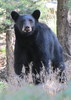
Following the ridge toward the peak was a relatively easy mix of unstable mountainside traverse and picking my way up through boulders and oak brush. Reaching the western shoulder of the peak, the summit cone came into full view. I was greeted shortly after by the loud buzzing of a black tailed rattlesnake in full strike position a few feet ahead of me. It seemed a fitting greeting from a peak with the name "Deadman" in it.

The fairly easy off trail hiking came to an abrupt end as I approached Deadman's summit cone. I fought, stumbled and slid through rock outcrops and thick vegetation to reach what I believed would be a natural access ramp on the west face of the peak. This ramp was a steep rock slide of somewhat loose boulders, which I carefully made my way up as a hawk screeched at me from above.

The top of the rock slide resulted in a dead end at the base of a cliff. Doubt returned. I backtracked slightly and found a way to access the peak's north ridge, which I began to scramble up. The narrow ridge, with cliffs on either side, dead ended at a notch about 40 vertical feet below the summit. Pausing, I dropped my pack, noted a few available hand and footholds, and pulled myself up a little wall.

I was soon on the gray, rocky summit, amazed that the peak was actually able to be climbed and relieved that all of my effort was not in vain. After numerous photos, videos, shouts and smiles, I added my name to the two others in the summit log, and then placed it inside a larger jar that I had brought. Satisfied, I began my descent.

The descent from the peak went much faster, now that I knew the route, but the vegetation-induced bloodletting continued. I was happy to leave the rock slide behind after a close call with a loose boulder. Two and a half hours later, I was back at the Gibson Canyon trailhead, only slightly worse for the wear with a bruised knee and bleeding shins.

The route that had looked only slightly possible and very sketchy from long distance observations and satellite images had proven to be possible. In climbing this peak, one of my biggest hiking goals had been completed.

In conclusion, for anyone with significant off trail hiking and scrambling experience, this peak should not be a problem. Might be wise to not go alone on this one. I'd say it's not for beginner or inexperienced hikers or those with a fear of heights, though. My climb rating in this triplog is my best guess.

water 1 out of 5water 2 out of 5water less than maxwater less than max Round the Mountain Spring Quart per minute Quart per minute
Mild flow where the Round The Mountain Trail crosses the spring area.
_____________________
"…you never know when a hike might break out" -Jim Gaffigan
 
Jan 21 2013
avatar

 Photos 4
 Triplogs 5

82 female
 Joined Nov 04 2011
 Safford, AZ
Gibson Canyon Trail #308Tucson, AZ
Tucson, AZ
Hiking avatar Jan 21 2013
ppriceazTriplogs 5
Hiking8.00 Miles 6,447 AEG
Hiking8.00 Miles   6 Hrs      1.60 mph
6,447 ft AEG   1 Hour    Break
 no routesno photosets
1st trip
Partners none no partners
We drove two vehicles off FR57 to the Gibson Canyon TH, and then returned in one to the Round the Mountain TH at the horse corrals near Noon Creek. (The FR57 is rough and probably a higher clearance vehicle will make you feel more comfortable.) With two vehicles we got to experience the entire trail. This was a hike with everything: views, water, good trail, big climbs and descents, forest and desert. Today was a gorgeous Arizona day. Our two faster hikers could have completed the hike in less than 5 hours, but I'm a slower hiker and with a lunch break at Gibson Creek, we got back to the vehicle in six hours. There was some snow on the shaded upper parts of the trail and a beautiful ice flow down from Gibson Creek. Marijilda had good flow but we crossed it easily. The trail was not difficult to follow, but it helped being with a hiker who is good at keeping on the trail.

water 1 out of 5water 2 out of 5water 3 out of 5water less than max Carls Spring Gallon per minute Gallon per minute
Nice pools and gentle flow on Marijilda Creek.
_____________________
 
Jan 30 2012
avatar

 Guides 4
 Photos 4,732
 Triplogs 2,607

55 male
 Joined Sep 29 2004
 Small Town USA
Gibson Canyon Trail #308Tucson, AZ
Tucson, AZ
Hiking avatar Jan 30 2012
SkyIslander18Triplogs 2,607
Hiking6.92 Miles 1,710 AEG
Hiking6.92 Miles   6 Hrs   15 Mns   1.85 mph
1,710 ft AEG   2 Hrs   30 Mns Break
 no routes
Linked   linked  
Partners none no partners
Today's trip turned out much better then yesterday's - I was able to actually make it down the forest road to the trail-head and hike! Parked down beside Marijilda Creek and headed up the Gibson Canyon trail. Made it up to the Round the Mountain T and hung a left taking RTM down to Gibson Creek Canyon to see if I could get down to the waterfalls & tinajas. From the top looking down into the deep canyon, I could see the pools and hear the waterfalls, but just could not find a safe route down to them. Returned back the way I came stopping at "S" canyon which had some running water in it and then ending the day along Marijilda Creek for sunset. A little warm for a January hike along this mostly shadeless trail, but a lot of good views & fun!
_____________________
https://www.instagram.com/skyislander22/
 
Mar 25 2011
avatar

 Guides 4
 Photos 4,732
 Triplogs 2,607

55 male
 Joined Sep 29 2004
 Small Town USA
Gibson Canyon Trail #308Tucson, AZ
Tucson, AZ
Hiking avatar Mar 25 2011
SkyIslander18Triplogs 2,607
Hiking7.58 Miles 1,834 AEG
Hiking7.58 Miles   3 Hrs   15 Mns   5.05 mph
1,834 ft AEG   1 Hour   45 Mns Break
 no routes
Linked   linked  
Partners none no partners
Arrived at the TH after one scary Marijilda Creek crossing that I was not sure my little Ford Ranger was going to be able to make! Headed up the mountain on the Gibson Canyon trail for a couple of miles until it met up with the Round The Mountain trail. Hung a left onto RTM and took it down to Marijilda Creek and then back out the way I came. I saw some pretty spectacular waterfalls down in the unnamed canyon before Marijilda Canyon that will have me coming back in the future. Very scenic & fun trip today!
wildflower observationwildflower observationwildflower observationwildflower observationwildflower observation
Wildflowers Observation Light
_____________________
https://www.instagram.com/skyislander22/
  2 archives
Jan 02 2011
avatar

 Guides 170
 Routes 148
 Photos 5,914
 Triplogs 2,097

48 male
 Joined Apr 12 2004
 Tucson, AZ
Gibson Canyon Trail #308Tucson, AZ
Tucson, AZ
Hiking avatar Jan 02 2011
PrestonSandsTriplogs 2,097
Hiking5.40 Miles 1,660 AEG
Hiking5.40 Miles
1,660 ft AEG
 
1st trip
Linked   none no linked trail guides
Partners none no partners
With the upper Pinaleno's snowed in, I decided to check out the bottom end of the Gibson Canyon Trail. Driving in on FR 57, I reached Marijilda Creek and discovered that the road crossing had been repaired. :y: The crossing is now high clearance instead of freaking nuts, and will likely remain that way until the next flash flood.

I drove all the way in to the "official" trailhead, where there was a sign for the Gibson Canyon Trail. The lower section (2.5 miles) of the Gibson Canyon Trail was easy to follow and well cairned, and climbed steadily through grassland and scattered oaks, following the route of an ancient, eroded road (an old sawmill road?). High snow covered peaks were in constant view. S Canyon contained a few small waterfalls.

I hit solid snow at 5400 feet, reached the Round The Mountain Trail at 5500 feet, then followed it south for a fridgid third of a mile to the signed junction of the upper section of the Gibson Canyon Trail. Saw several trail cameras in trees along the way. I struggled up the snowy slope, trying to follow the upper trail, but had a tough time (which I had always expected I would) due to the fire damage, regrowth, and snow covering. I turned around at sunset after 0.25 miles, and headed back down.

Several years of procrastination due to a belief that this trail was likely vanished ended today, and I got to experience some new territory and a great little hike. If you go, avoid summer on the lower section of this trail, there is no shade.

FYI: The upper end of the Gibson Canyon Trail near High Peak Cienega is totally gone, so the entire section of trail above the Round The Mountain Trail will likely be very challenging.
 Meteorology
 Meteorology [ checklist ]
[ checklist ]  Fire Burn Area & Recovery
_____________________
"…you never know when a hike might break out" -Jim Gaffigan
 
average hiking speed 1.79 mph

WARNING! Hiking and outdoor related sports can be dangerous. Be responsible and prepare for the trip. Study the area you are entering and plan accordingly. Dress for the current and unexpected weather changes. Take plenty of water. Never go alone. Make an itinerary with your plan(s), route(s), destination(s) and expected return time. Give your itinerary to trusted family and/or friends.

helpcommentissue

end of page marker