 Route Editor

| Guide | ♦ | 44 Triplogs | 1 Topic |
details | drive | permit | forecast | 🔥 route |
stats |
photos | triplogs | topic | location |
| 266 | 44 | 1 |
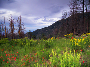
Six white horses: Yee-haw by HAZ_Hikebot  This trail doesn't go all the way 'round the mountain, but it goes far enough to provide some spectacular views and to give you a good idea of the size of this "Sky Island." Round the Mountain Trail travels a gradually ascending course through oak woodlands and stands of mixed conifers. Along the way, it presents a steadily changing panorama of the Gila River Valley and the Gila Mountains, along with good views of Deadman Peak, Heliograph Peak, and Mount Graham of the Pinalenos. This trail doesn't go all the way 'round the mountain, but it goes far enough to provide some spectacular views and to give you a good idea of the size of this "Sky Island." Round the Mountain Trail travels a gradually ascending course through oak woodlands and stands of mixed conifers. Along the way, it presents a steadily changing panorama of the Gila River Valley and the Gila Mountains, along with good views of Deadman Peak, Heliograph Peak, and Mount Graham of the Pinalenos.You can start just as easily at either end of the trail - at the Round the Mountain Trailhead and Picnic Area about a mile above Noon Creek Picnic Area on the Swift Trail, or at the trailhead just below the Bible Camp at the end of the Columbine Road. Water can be found in a number of small streams along the trail, including Marijilda, Deadman, and Frye Creeks, as well as in Gibson Creek and Round the Mountain Spring (except in a severe drought). This is a good trail for wildlife watching, too. White-tailed deer and black bear are frequently sighted here, and if you don't see a bear you should still see plenty of evidence of them. Round the Mountain Trail is well suited to both hiking and horseback riding and it serves as a convenient connector to several other trails. Among these is Noon Creek Ridge Trail #318, Gibson Canyon Trail #308, Deadman Trail #70, Frye Canyon Trail #36, and Ash Ridge Trail #327.
Check out the Official Route and Triplogs. Note This is a difficult hike. It would be insane to attempt this entire hike without prior experience hiking. Leave No Trace and +Add a Triplog after your hike to support this local community. One-Way Notice This hike is listed as One-Way. When hiking several trails on a single "hike", log it with a generic name that describes the hike. Then link the trails traveled, check out the example. | |||||||||||||||||||||||||||||||||||||||||||||||||||||||||||||||||||||||||||||||||||||||||||||||||||||||||||||||||||||||||||||||||||||||||||||||||||||||||||||||||||||||||||||||||||||||||||||||||||||||


