username
X
password
register
for free!
help
ArticlesGuidesRoutes
 
Photosets
 
 Comments
triplogs   photosets   labels comments more
Neon Canyon - 5 members in 8 triplogs have rated this an average 4.8 ( 1 to 5 best )
8 triplogs
login for filter options
Mar 17 2025
avatar

 Routes 386
 Photos 49
 Triplogs 792

43 female
 Joined Jun 23 2015
 Phoenix, AZ
Neon CanyonSouthwest, UT
Southwest, UT
Hiking avatar Mar 17 2025
emilystardustTriplogs 792
Hiking7.01 Miles 1,328 AEG
Hiking7.01 Miles   4 Hrs   21 Mns   1.78 mph
1,328 ft AEG      25 Mns Break
 
no photosets
1st trip
Linked   none no linked trail guides
Partners none no partners
Route Scout Route Recorded  on Route Scout | Pop | Map | Popup | MapDEX
We took a gamble with the recent storm but the weather was nice enough that we went for it. Water crossing was too high, fast, and cold for comfort so we decided not to go for it. Still a pretty hike and there’s always next time.
_____________________
 
Mar 27 2021
avatar

 Photos 5
 Triplogs 25

male
 Joined May 25 2009
 flagstaff,az
Neon CanyonSouthwest, UT
Southwest, UT
Canyoneering avatar Mar 27 2021
markguycanTriplogs 25
Canyoneering12.00 Miles 2,000 AEG
Canyoneering12.00 Miles   9 Hrs   30 Mns   1.26 mph
2,000 ft AEG40 LBS Pack
III - Normally requires most of a day
 no routesno photosets
1st trip
Linked   none no linked trail guides
Partners none no partners
Neon had been on my to do list since I first heard about it 20 years ago.
I was a bit concerned following the weather forecast a few days before our planned attempt. Chance of rain came and went then the evening before a storm set in and snowed 2inches at the Egypt Trailhead. It continued to spit snow and rain the next day so we opted for some safer adventures in the area.

The next day was our last in the area so we felt some pressure to make it happen.
We had a leisurely start hoping for it to warm up as there was still snow at the trail head and the potholes descending from it had ice. We left the car a bit after 1030, and made it to the Escalante about 12:00. The approach to the drop in point was pretty straight forward and we found the short rap opposite and just upstream of the moki steps in good condition. We donned our farmer johns and rap'd in.

It was 13:00, so I ate a snack. A short walk downstream lead us to the start of the slot and our second rap: low angle for about 30ft, this anchor was also in good condition. We donned our wet suit jackets as this rap landed us in a pool (turned out to be thigh deep) We were able to keep the rope mostly dry by rapping single line with a 'biner block with the last coming down removing the 'biner, rapping double rope and carrying the rope bag.

Another short rap and pool followed a short way down the slot. Anchor was good, rap was awkward initially. Water was knee deep.

The slot became even more 3 dimensional -not quite 4th dimension but 3+ :) when little rooms inside arches appeared offering 3 ways to get to the same rap point. This was the rap into the big keeper pothole. Even with all the precip the day before it was dry and fairly full of sand making for easy escape. Of note there is a small hole on the lip which would be perfect for hooking out.

After a few minutes of easier terrain the final glory rap appears. Long webbing (doubled) stretches into the slot above the hole which drops into the Golden Cathedral. 3 old bolts remain in the wall above this without hangars, these could be utilized with sacrificial climbing nuts. The glory rap is over all too quick but it is awesome and perfect with the golden light. There was less water than I expected finding it only about calf deep. We had a nice lunch on the sand bar it was 14:30.

From there we headed back down canyon to the Escalante and then 30min further down the Escalante River to explore Ringtail Canyon. Ringtail is the next canyon on river left. It is rather short but very narrow; a head lamp is a good idea as is a farmer john wetsuit. Explore up canyon as far as you can then come back down.

Then returning the way we came (mostly as we veered off course and lost our cairn'd way heading too north) We did appreciate several arches forming a couple of rooms but it likely added a mile to our hike.

Back at the car just before sunset at 19:30.

With the conditions we experienced I would have foregone the extra 200ft rope, bolt kit and wet suit jackets. Instead I would have carried an extra 80-100ft rope. I only carried 2L of water then treated 1L clean-ish water from a pothole in Ringtail but ended up only needing 0.5L of it; so, with highs of 58F I think 2.5L would be ideal, personally.
_____________________
  7 archives
Jun 02 2018
avatar

 Photos 377
 Triplogs 579

female
 Joined Jun 19 2009
 AZ
Escalante Adventures, UT 
Escalante Adventures, UT
 
Hiking avatar Jun 02 2018
oceanwithinTriplogs 579
Hiking27.00 Miles
Hiking27.00 Miles
 no routesno photosets
1st trip
Linked   linked  
Partners none no partners
An awesome trip to Escalante over Memorial Day weekend.

Friday: The Black Hole of White Canyon (Cedar Mesa):

After years of saying "someday...!" while driving past the TH, we were finally able to pull this one off on our way to Escalante. The black hole was a fun hike through a beautiful canyon, with long sections of COLD swimming between narrow walls. No rappels, but there are a few good down-climbs. A couple sections get deep and dark, hence the name of the canyon. I was happy to have a 5mm wetsuit.

After making it out, we had a 4.5 hour drive ahead of us to Escalante, followed by a hike down Fence Canyon with our backpacking & canyoneering gear for the next two days of adventures.

Saturday: Choprock Canyon

I'll admit, I was feeling nervous about Choprock. The history of two deaths from hypothermia and the legends of the logjam-from-hell had me feeling anxious the entire approach hike in. Choprock has 3 distinct sections: Riparian, Happy and Grim. The Riparian section felt like something out of an Indiana Jones movie, as we swam through thickets of vegetation while attempting to dodge the horrifying amounts of poison ivy that grew along the banks. At points you had no choice but to hike through the face-high ivy, but thankfully this section was pretty short lived. Then came the aptly-named Happy section, which was a pretty easy-going splash through pools and hallways of dramatically sculpted canyon walls. The happiness very abruptly ended as we soon found ourselves deep in the Grim section, the part I had been the most nervous about. The anxiousness was for nothing, thankfully, as Choprock was in "easy mode" with very low water which made this section easier than normal. Even in easy mode, this section was still difficult and very physical with lots of stemming, hauling yourself over log jams, long elevator down-climbs and cold swims.

Aside from it being an incredibly beautiful place, the best part about Choprock is that there are moki steps steps at one of the rappels, carved up a sheer cliff face in the middle of the canyon. An excellent but exhausting day indeed.


Sunday: Neon Canyon

Neon had long been on my bucket list and I had been wanting to go there for years after I first saw a photo of the Golden Cathedral. Above the Golden Cathedral is more gorgeous canyon with some really neat features, including some deep keeper potholes. The entire thing was bone dry so we zoomed through and spent some time at the cathedral before continuing on to pick up the rest of our gear for the sandy slog out.

For being a holiday, we really didn't see many other people the entire weekend until we reached the Golden Cathedral. As always, Utah did not disappoint and I can't wait to go back to explore more. Great times with great people. :y:
_____________________
 
Nov 25 2017
avatar

 Guides 6
 Routes 183
 Photos 5,612
 Triplogs 1,647

male
 Joined Mar 12 2004
 Scottsdale, AZ
Neon CanyonSouthwest, UT
Southwest, UT
Hiking avatar Nov 25 2017
John9LTriplogs 1,647
Hiking10.50 Miles 1,800 AEG
Hiking10.50 Miles   4 Hrs   50 Mns   2.39 mph
1,800 ft AEG      26 Mns Break
 
1st trip
Linked   linked  
Partners partners
BiFrost
On the third day of our four trip, we made the long drive to the Egypt TH. The ten mile road is a bit rough and a high clearance vehicle is a must. Don’t take a passenger car here.

We hit the trail around 10:20am and started the hike. The route makes a steep drop off the rim as you head east for Neon Canyon. I didn’t do any research for this hike but thankfully Karl did. He had a GPS route that included a direct route that leads straight towards Neon Canyon. This turned out to be a great option. The overland route follows a defined use trail through a mix of deep sand and sandstone. We continued on and eventually dropped to the Escalante River where we made our first crossing in knee deep water. Once over the Escalante we found ourselves at the mouth of Neon Canyon. From there it’s roughly one mile of easy hiking to the Golden Cathedral. This section went by fast and next thing we know we’re there. The Golden Cathedral is just spectacular! The rock rises up and wraps around forming a ceiling with two holes. Words can’t describe how amazing this place is! The only way it can be better is if a group rappelled down.

After we took a break at the Golden Cathedral, we started the hike out and followed the standard hiking route. The route heads north and follows the Escalante River. There were five wet crossings through the cold water that was mostly knee deep. One spot came up to our thighs but wasn’t too bad. After the crossings we turned west and started the hike up Fence Canyon. After a mile or so we left the main trail with the plan to check out the canyon. We continued on a bit but our use trail was swallowed up by brush so we decided to cut our losses short and we returned to the main trail. The rest of the hike out was uneventful and we were back to the Egypt TH around 3pm.

The Golden Cathedral is truly magnificent! It wasn’t in our original plan but I’m glad we changed our itinerary and made it happen. It was the perfect day hike! Afterward, we returned to the Hole in the Rock Road and found a campsite near the Zebra Slot TH. We’re doing one more hike the next morning and then returning to Phoenix.
_____________________
  1 archive
Nov 25 2017
avatar

 Guides 4
 Routes 491
 Photos 10,890
 Triplogs 1,257

55 male
 Joined Nov 20 2012
 Phoenix, AZ
Neon CanyonSouthwest, UT
Southwest, UT
Hiking avatar Nov 25 2017
BiFrostTriplogs 1,257
Hiking10.50 Miles 1,800 AEG
Hiking10.50 Miles   4 Hrs   50 Mns   2.39 mph
1,800 ft AEG      26 Mns Break
 no routes
1st trip
Linked   linked  
Partners partners
John9L
We had not planned on doing this hike originally but we managed to adjust our plan and make this one happen. We both agreed it was the best choice and high on the priority list. Fortunately I had downloaded the route just in case although it's possible to do without a route but helps while traversing the flat sandstone section between canyons. As John mentioned we went in the direct route that is not the standard but still able to follow to the confluence of Neon.

We hiked up Neon about 1 mile and enjoyed the Golden Cathedral of Neon. It's really a cool place and pictures and words really can't describe this geologic feature. You just have to see it for yourself. There were not very many people either for such a popular hike so we had some peace and quiet to enjoy the setting.

After that we headed out but went back the standard route to the north along Fence Canyon. However, with the standard route it requires five Escalante crossings as opposed to one for the way we hiked in. None of the crossings were too difficult but water was colder than expected. Once across the last crossing the route is easy to follow all the way back to where the paths converge near the trailhead. It was cool to do this hike taking too different routes out and back to Neon and definitely worth making it a loop hike.
_____________________
  1 archive
Oct 09 2017
avatar

 Guides 37
 Routes 556
 Photos 10,872
 Triplogs 1,052

43 male
 Joined Jan 21 2013
 AZ
Neon CanyonSouthwest, UT
Southwest, UT
Hiking avatar Oct 09 2017
FOTGTriplogs 1,052
Hiking10.83 Miles 2,695 AEG
Hiking10.83 Miles
2,695 ft AEG
 no routes
1st trip
Linked   none no linked trail guides
Partners none no partners
After backpacking out of Coyote Gulch, we made the frame rattling drive to the Egypt trailhead for an attempt at the Golden Cathedral. We were successful in finding this magical place and it is truly special and worth the effort.

We had the entire canyon and cathedral to ourselves and only saw one other group on the way out. The key to this hike is Fence Canyon, we opted for a route along the right side of Fence that amounted to a cairn hunt, but a manageable cairn hunt. There clearly appears to be a more established route down its left side, however, going down the center of the canyon is not an option, unless one can fly, or unless one has a few hundred feet of rope to navigate the knee buckling pour-over that guards its upper reaches. Our route was certainly a little more rugged than the one that appeared on the other side of the canyon, but we managed just fine. I kept thinking we might be coming to an inevitable cliff and the end of our route, but the cairns held true and got us down to the Escalante through the narrowest of breaks. After reaching the Escalante it was down stream to Neon and then up canyon to the fabled Golden Cathedral. We spent probably close to an hour hanging out there and took several dozen photos. Carrie noted that it may have been one of the most awe inspiring sites she has been to and I think I agree. A very humbling, special place indeed.

I don't want to be overly coy, but I prefer to help keep this destination wild and will refrain from posting a route. However, if interested in some more details pertaining to the route, fee free to PM.
_____________________
  2 archives
Apr 28 2012
avatar

 Routes 5
 Photos 34
 Triplogs 210

54 male
 Joined Jul 19 2009
 Phoenix, AZ
Neon CanyonSouthwest, UT
Southwest, UT
Canyoneering avatar Apr 28 2012
markyarchTriplogs 210
Canyoneering7.25 Miles 700 AEG
Canyoneering7.25 Miles   5 Hrs      1.45 mph
700 ft AEG
Intermediate Canyoneering - Difficult or dangerous; Tech Climb; rope reqd; descent anchor; exit technical;
B - Up to light current; wading/swimming; possible wet/dry suit
Risky - Extraordinary risk factors exist; solid skills/judgement reqd; no beginners
II - Normally requires a half day
 no routesno photosets
1st trip
Linked   none no linked trail guides
Partners none no partners
Parked at Egypt TH and did Neon Canyon. Was prepared for a lot of water and wore a 5 mm wetsuit. That was a mistake. Very little water and sweated a lot. Great narrows and a few pools. Final rappel into the Cathedral was awesome. Most scenic rappel that I have done.
_____________________
 
May 16 2008
avatar

 Guides 5
 Photos 26,458
 Triplogs 807

female
 Joined Feb 15 2003
 outside, anywher
Escalante River, UT 
Escalante River, UT
 
Backpack avatar May 16 2008
RedRoxx44Triplogs 807
Backpack65.00 Miles
Backpack65.00 Miles6 Days         
 no routes
1st trip
Partners none no partners
I bolted out of Tucson to head north at noon, on a Fri. The drive was good, and I car camped off the road going over the Kaparowits Plateau out of Big Water that night. The evening in the badlands was a very nice one, I walked a little in the twilight to shake off the long drive and work week.
Up and over the Kelly Grade and plateau ( AKA "Wild Horse" mesa Zane Gray fans) via Smokey Mountain Rd. The dirt track was in great shape. It gets really rocky after Last Chance Canyon and dips in and out of the heads of some promising canyons. As they drop off into the plateau; I have explored some of them but I had other plans to fulfill. I rolled onto main street Escalante mid morning Sat, stopped at the BLM office, then off to Egypt TH off the Hole in the Rock road. I saddled up near noon, probably 8 vehicles at the TH. I hiked down part of the Fence canyon approach then took off directly toward the butte that marks the entrance to Neon canyon, then looped back and dropped into the Escalante river basin near Fence canyon's mouth.

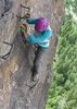
It was rather warm and later than I like to start any trip. I was glad to reach the river and wade right in. About shin deep here, certainly less than I have found in May before. I went a turn or two down the river, then dropped my pack to hike up Neon and visit the Golden Cathedral. I saw several groups of hikers, including some canyoneering guys who dropped thru the ceiling at the Cathedral--I just missed it. I was too late for good photo sun angle there, but a lovely wedge of light thru the potholes glowed like a virtual arrowhead on the surface of the pool in the Cathedral. I sat here a little while.
I continued down the Escalante, the bushwacking was certainly challenging in certain areas. The recent flood had cleared out some areas, but erased any sort of use trail near the river and big piles of deadfall was everywhere. I visited Ringtail, then decided to camp near the mouth of 25 mile wash; it was a little windy, and I found an overhang around a corner to set up my bivy. I was able to camp under some sort of natural shelter every night of this trip.
I was tired, and had a strange sort of aversion to this journey, entertaining turning around at this point. All I can say is I just had a case of the blas---nothing was really elevating my mood. A good night's sleep and the wonderful morning light on the cliffs turned my attitude around--- and now I was ready to move on.
My trip plan was down this section of the Escalante, check out some side canyons, and out at Hurricane Wash via Coyote Canyon, and then hitchhike back to Egypt TH. River miles approx--38. Total base trip--54 miles, possibly 60 miles with some side canyon hiking. I had covered some other areas of the Upper Escalante in past trips and I was particularly intrigued with the area below Scorpion Gulch to Stevens Canyon.
The river crossings were many and pleasant. Mostly ankle to knee deep. Some crawling up and sliding down banks holding onto willows. At times you could stay on the banks depending on your tolerance for bushwacking. The canyon walls were tall and at times close to the river, at times set back. Colorful, stained, jagged, then smooth. I love the sandstone geology.
I passed by the Moody's, some lovely dark efflurescent blues depending on light on the walls of East Moody. I kept pace again camping just short of Scorpion Gulch, which I planned to go up some distance the next day. The weather was just excellent, not very cold or warm and NO BUGS at all along the river. Conditions were near perfect for the trip. I knew to expect some stormy conditions coming the next day or two. Again, I had a little ledge and overhang, with a nice view of the river.
Up early, dropped my pack near the entrance and took some water, snacks and camera up Scorpion. Dodged the mass of poison ivy, a little scrambling and up this lovely canyon graced with idyllic pools and alcoves. It was just a wonderful diversion and that is all I will say about that. Someone once said the Escalante and it's side canyons are very reminiscent of a small version of Glen Canyon and it's side canyons. It that is true Lake Powell destroyed Eden.
Back down the river. My life is controlled by this river and it's canyon. There is nothing else for me. The clouds build, and the wind rose and the sun was gone. Soon the huge sandstone walls stood back more, the canyon widened and the Chinle and Shinarump(?) formation showed up, and much more rubble and talus slides near the river. Large boulders in the river now, and large aquamarine pools, water depth well over my head. The narrow river bed broadened, still shallows found to cross, but the Escalante now more like a true river, with small rapids and a little more volume.
I lucked out on the best spot to spend the night for the rain storm. I found a hollowed out boulder with another boulder leaning over it, and a tunnel formed with a little recessed window. The flood had driven in a soft loose bed of sand, and flushed out a packrat nest, nothing much left. You had to climb up a small boulder at the foot, crawl in on hands and knees about 3 feet then at the rear a small recess that allowed one person to sit up. I dragged my pack in there. It was so warm I simply scooped out sand for my hips and shoulders and just layed my bag over me. I arranged all my things, even a handy ledge to leave my wet boots on.
I slept very well, in fact didn't even know it was raining till I woke up in the night and decided to look out. My headlamp picked up the vegetation waving around in the wind and shiny with rain. Rain dripped off the window ledge but I remained totally dry and wind free. It was a great little spot I dubbed my " sand cave"--enough room for one and definitely not for the claustrophobic.

The next morning the clouds moved out and it looked like a stellar day. As usual--down the river. The section past George canyon ( local name, not on the Trails' Illustrated Canyons of the Escalante map) was very tough. The bushwacking issue was gone, it was nothing but rock and some much too short sand and cobble beaches. Rock, rock and more rock. Little rocks, big rocks, megaliths. Sometimes climbing up as much as 30-50 feet above the river to avoid boulder jumbles. In some places this was very slow going. Crawling thru rocks, some backtracking when your route didn't go --unless you wanted to swim. Persistence and remembering to enjoy your surroundings was the key here. You will thank your lucky stars for a lightly loaded and well balanced pack in this section. It was definitely an ankle twister. At one point I took off my pack and threw it up on a sand bank and climbed up on a bush to get around a bad area. Not a lot of pictures this day. I did take one picture I like to look at-- it shows a wall detail just down canyon. It seems so close. It took me almost an hour to get there.

And yes the canyon was gloriously beautiful. I saw a few tracks but I saw no one after Neon. I was alone in a great big beautiful world all my own it seemed. I judged my progress by the side canyons, but I just watched for Steven's arch; when I saw that I knew I was almost done, as usual a relief and a let down. When I reached Steven's canyon I set up camp under a shallow overhang on the big beach opposite the canyon. Spring days are long, and I went up the canyon aways. I had pilot error with a leak from my MSR dromedary so set out some things to dry under the sun. I had bagged my sleeping bag and long johns and spare socks so they were fine. It was a fine lazy afternoon, and I enjoyed the general sloth I exhibited.

The next day to go up Coyote Gulch. I have hiked in here a few times--it is a premiere canyon of the Escalante and sees lots of use. I entered where the canyon meets the Escalante; in years of higher water levels from Lake Powell a high water route leaves shortly below Steven's canyon.
The gentle stream in Coyote is so different from the muscular Escalante. The Escalante was clear enough I was able to use it as a good water source. Coyote's stream is shallow and silty, but the canyon is graced with a number of springs. You wander by the sandslide route from Crack in the Wall and about 7 people were camped here. Past that Coyote stream meanders in a slickrock bed in spots and has some pretty, small waterfalls, one fun to get around solo with a big pack.
The canyon is intimate then the walls start getting bigger. It is truely a photographers dream in here too. I come to a significant spot for me--Coyote Natural Bridge. Around 2001 I was undergoing treatment for non-Hodgkin's lymphoma, and came to Utah to spend time to heal--and get strength from these wonderful surroundings to fight my cancer. I was five days after chemo 3 I think--I was bald, and my good friend Jerry from SoCal met me here to backpack Coyote as an overnighter. We went in at the Crack and out Hurricane. I had had a few bad days previous but was feeling amazingly well for the backpack, and I was carrying my own stuff. I remember resting at the bridge and feeling so amazed at the beauty of my surroundings--how could I leave this??? So much more to see and do. I felt for the first time all would be ok for me. After that point in time I had some down times but I never looked back; never doubted I would not be around in the future. And I am still here and doing my thing. I am thankful forever for this new life.

I make my photos, reflect, and walk on. Soon the massive undercuts, and Jacob Hamblin arch, appear. A young couple pass me by hiking out. I take one pic of the young man in the largest alcove, to give scale. He is a speck in the now gigantic landscape. Besides the one group camped and this couple and myself were the only folks I saw in Coyote Gulch. Whether it is the gas prices or because it was during the week or the forecast; I was surprised at the small populace in here.
I approach the Hurricane confluence. Because I want to start my hitchhike early in the day to maximize ride potential and to have enough water in case a long trek back to my car 35 road miles away, I again camp early in a sizable alcove just around the corner of the confluence. A nice side canyon comes in with clean clear water. I explore, and note the dark clouds drifting over again. My alcove is quite large and deep, and again I have no fear of the weather--I hope it storms like hell, which it doesn't.
The next day the slog out Hurricane, to the road. My pack is heavy with water. I start my road walk, under gray and stormy skies, a light wind, and thankfully the sun was tucked away. It was actually quite beautiful with the big clouds over the straight cliffs. I stop and talk to several folks, a couple from the Netherlands, a father and son in a Jeep. They are going the wrong way but all agree when they return up the road to give me a ride. I keep walking. Seems like I am programmed to do that. Finally, a great couple, Tracy and Keith from Salt Lake City give me a ride in their Land Rover-- all the way to Egypt TH; out of their way. I had walked about 10 road miles at that point. I was getting tired so the ride was quite a luxury.
I was glad to see my Toyota. I reckon about 65-70 miles for this little sortie. An excellent memorable trip.

I still have more time but I am tired and sore so want lighter hiking. I leave Escalante, make my way to outside of Hanksville, a pleasant view filled drive and you pass thru Capitol Reef. I wanted to visit some lovely narrows I photographed maybe 8 or so years ago. I took the dirt road toward the Dirty Devil, then the mining road that contours above the river almost 1500 feet up. I car camped among huge boulders and sat and let my legs dangle off a ledge looking down at the river basin far below. Tomorrow I would be down there. The wind rose and I was glad to sleep in the back of the car, listening to the howling that lasted far into the night.
The morning walk down the old mining track was delightful. Now there is a little trail, before there were no footprints. There is a cairn off the point and a trail down; before I just dived off here and got down via ledges to the final little plateau and cattle trail down to the River level. Cross, and into the Narrows. I got some fair light, and took a lot of pics, and thought how I enjoyed this area, the hike in total and the expansive views after the world in the canyons.
Well, that is my trip and all that.
_____________________
 
average hiking speed 1.85 mph

WARNING! Hiking and outdoor related sports can be dangerous. Be responsible and prepare for the trip. Study the area you are entering and plan accordingly. Dress for the current and unexpected weather changes. Take plenty of water. Never go alone. Make an itinerary with your plan(s), route(s), destination(s) and expected return time. Give your itinerary to trusted family and/or friends.

helpcommentissue

end of page marker