username
X
password
register
for free!
help
ArticlesGuidesRoutes
 
Photosets
 
 Comments
triplogs   photosets   labels comments more
Shake Tree Canyon - 4 members in 10 triplogs have rated this an average 4.3 ( 1 to 5 best )
10 triplogs
login for filter options
Apr 02 2022
avatar

 Guides 41
 Routes 1,626
 Photos 14,983
 Triplogs 2,760

69 male
 Joined Jan 20 2009
 Far NE Phoenix,
Deer Creek - Shake Ridge & Shake Tree Cyn Loop, AZ 
Deer Creek - Shake Ridge & Shake Tree Cyn Loop, AZ
 
Hiking avatar Apr 02 2022
The_EagleTriplogs 2,760
Hiking12.17 Miles 2,128 AEG
Hiking12.17 Miles   8 Hrs   28 Mns   1.73 mph
2,128 ft AEG   1 Hour   26 Mns Break14 LBS Pack
 
1st trip
Linked   linked  
Partners partners
joebartels
Route Scout Route Recorded  on Route Scout | Pop | Map | Popup | MapDEX
I through out 2 options this week. One stuck to trails, and had an abundance of flowers the last time we did it. Option 2, either covered all new ground off trail or from the last reports, on a trail that was reported severely overgrown the end of last year. Joe responded, "Option 2", I responded "Oh Crap".

The original Option 2 was 18+ miles and 4000+ feet of AEG. Unless the canyon hiking was quick, there would be no chance of completing, so there were bail points.

We hit Deer Creek and were surprised by how heavy the flow was. Shortly thereafter, it was time to start the 5 mile climb up Shake Ridge, to our drop in point. It used a combination of old FR's to their end, and a surprisingly good use/game trail started. We took this to our drop in to Shake Tree Canyon.

This was the first area of concern. The lines were tight on the TOPO, but looked doable. But you never know if you are going to get cliffed out. We picked a spot and dropped in. It started as a steep, loose, agave and prickly pear dodgeball track. We got lucky a part of the way down and hooked up on some sort of an old use trail off and on that took us to the bottom.

There was a good deal of water running in the creek. My goal was to go find the falls, which I find out later, were 165' tall. After fighting the tangled brush from past floods, for no more than 150', I gave up. We started our exit from Shake Tree Canyon fighting the same sorts of things, sometimes hopping out momentarily to bypass some of the thicker areas.

It became evident at lunch, that we were going to be cutting the planned track short. The last 3 miles had taken almost 4 hours. We headed through the catclaw towards an actual trail, Deer Creek #45. The last triplog I read from Oct 2021 from @hikerdw, stated that the trail was severely overgrown. I'm happy to report, from the point we got on the trail at the Davey Gowan gravesite, to the TH, the trail had seen lots-o-work. It's now a super highway.

It was a good day hitting some new areas. Shake Ridge was better than expected. Shake Tree Canyon, Bars Canyon and Deer Creek were all running very nicely. We still have some unfinished business in the area.
 Named place
 Named place [ checklist ]
[ checklist ]  David D. Gowan
wildflower observationwildflower observationwildflower observationwildflower observationwildflower observation
Wildflowers Observation Moderate
The most flowers and varieties seen on any hike this year to date

water 1 out of 5water 2 out of 5water 3 out of 5water less than max Bars Canyon Medium flow Medium flow


water 1 out of 5water 2 out of 5water 3 out of 5water less than max Shake Tree Canyon Medium flow Medium flow
_____________________
There is a very fine line between "hobby" and "mental illness."
Dave Barry 🦅
 
Mar 30 2019
avatar

 Guides 1
 Routes 269
 Photos 613
 Triplogs 1,360

50 male
 Joined Dec 22 2003
 Tucson, AZ
Shake Tree CanyonPayson, AZ
Payson, AZ
Canyoneering avatar Mar 30 2019
RedwallNHopsTriplogs 1,360
Canyoneering5.00 Miles 3,000 AEG
Canyoneering5.00 Miles
3,000 ft AEG
 no routesno photosets
1st trip
Linked   none no linked trail guides
Partners none no partners
Great weekend in the Mazzies. Water was flowing great and was coooooold. Can't believe it took me so many years for my first trip to this range.
_____________________
 
Apr 08 2017
avatar

 Guides 26
 Routes 21
 Photos 562
 Triplogs 1,393

female
 Joined Jan 04 2011
 Las Vegas, NV
Shake Tree CanyonPayson, AZ
Payson, AZ
Canyoneering avatar Apr 08 2017
autumnstarsTriplogs 1,393
Canyoneering2.61 Miles 1,469 AEG
Canyoneering2.61 Miles
1,469 ft AEG
Intermediate Canyoneering - Difficult or dangerous; Tech Climb; rope reqd; descent anchor; exit technical;
B - Up to light current; wading/swimming; possible wet/dry suit
III - Normally requires most of a day
 no routes
1st trip
Linked   linked  
Partners none no partners
After arriving at the AZ Canyoneering Rendezvous, we looked around for a less commonly run canyon to sign up for.

We found only incomplete beta for this canyon, and none of our group had ever run it, but that just added a fun challenge to my way of thinking. Turned out to be a beautiful canyon with a nice amount of water flow over the waterfalls on this day. The beta we did have didn't exactly line up with what we were seeing, but with an array of natural anchors to select from, that was no surprise. In canyon, we couldn't figure out the purpose of the secondary station on the longest rappel and didn't utilize it. But after re-reading the beta, I realize previous parties were using a different anchor for the first section of that rappel, resulting in a difficult pull. We had no issues and were able to just enjoy the beauty of the canyon.

Interesting canyon - it is well hidden from above and you would really never know anything particularly interesting was down there unless you happened to hear the water flow. We enjoyed splashing around in the water and just generally having a good time. Our selected route out was a terrible scramble up a steep ridge, complete with bush-whacking through cacti and agave. But it was over quickly, so we were all happy for that.

We used a lifted pickup to access the 4X4 alternate start/end point. In the end, that road is such slow going that we probably spent more time driving than it would have taken to hike in and out on the Y-Bar (Shake Tree) Trail. Probably not worth it depending on your vehicle and patience.
wildflower observationwildflower observationwildflower observationwildflower observationwildflower observation
Wildflowers Observation Isolated

water 1 out of 5water 2 out of 5water 3 out of 5water less than max Shake Tree Canyon Medium flow Medium flow
_____________________
"Let it ride / Let it roll / Let it go"
  3 archives
Apr 25 2016
avatar

 Guides 2
 Photos 1,691
 Triplogs 212

45 male
 Joined Aug 05 2004
 Peoria, AZ
Shake Tree CanyonPayson, AZ
Payson, AZ
Canyoneering avatar Apr 25 2016
desert_boonieTriplogs 212
Canyoneering5.80 Miles 3,000 AEG
Canyoneering5.80 Miles   7 Hrs   30 Mns   0.77 mph
3,000 ft AEG
 no routes
1st trip
Linked   none no linked trail guides
Partners none no partners
Clear blue skies over head, gusting wind all day long, water running in the canyon and the temperature did not go over 65 the entire day. You put all that together and you know you are in for one great day. Jake and I arrived at the trailhead just after 8am and both noticed it was slightly chilly out, oh well, once we head uphill we'll warm up quickly. The Y-bar is as rocky as ever and we made great time getting up to the drop in point with fantastic views to be had. We stopped for a bite to eat before entering the canyon to raise our body temperature up since we knew we were getting wet and didn't bother to bring any wetsuits. The first drop in is an amazing sculpted bowl where the water was running and sparkling off the rock to make this canyon as scenic as it could get. It is a short canyon so to speak so the rappels come pretty rapid fire. The 160' drop is amazing and one of the best canyon rappels I have ever done. Halfway down I could only look up to see how far up the canyon walls go and get splashed at the same time, it was a good rush and a perfect setting. The rope pull took a lot at first but we got it without any issue. We turned the corner and thought we were hearing footsteps below us, it must have been the wind and we continued on into the real only pool of the day but it still was not a swimmer. No swimmers today, only chest high deep water. We thought the canyon was just about done but it just kept offering more and more drops. We were having a fantastic time and were almost sad when we knew out exit was finally upon us. This was certainly a great adventure with picture perfect weather, couldn't have asked for anything better today.

*Side Note* I found a camera at the bottom of the pool two rappels after the big drop. Not sure if the camera is going to be functional, but it does look like the memory card is working. I would like to find its rightful owner so if you were in the canyon recently send me a message and I can get it back to you.
_____________________
"Never Satisfied"
 
Jul 29 2012
avatar

 Guides 1
 Routes 3
 Photos 337
 Triplogs 311

41 male
 Joined May 31 2009
 
Shake Tree CanyonPayson, AZ
Payson, AZ
Canyoneering avatar Jul 29 2012
azflyguyTriplogs 311
Canyoneering5.00 Miles 3,000 AEG
Canyoneering5.00 Miles
3,000 ft AEG
 no routesno photosets
Linked   none no linked trail guides
Partners none no partners
_____________________
Canyoneering gear beta tester and supplier. Visit http://www.shadowcatadventures.com for canyoneering, climbing, hiking and backpacking gear.
 
Feb 18 2012
avatar

 Guides 1
 Routes 3
 Photos 337
 Triplogs 311

41 male
 Joined May 31 2009
 
Shake Tree CanyonPayson, AZ
Payson, AZ
Canyoneering avatar Feb 18 2012
azflyguyTriplogs 311
Canyoneering5.00 Miles 3,000 AEG
Canyoneering5.00 Miles
3,000 ft AEG
 no routesno photosets
Linked   none no linked trail guides
Partners none no partners
_____________________
Canyoneering gear beta tester and supplier. Visit http://www.shadowcatadventures.com for canyoneering, climbing, hiking and backpacking gear.
 
Jun 19 2011
avatar

 Photos 26
 Triplogs 8

39 male
 Joined Oct 19 2010
 Golden, CO
Shake Tree CanyonPayson, AZ
Payson, AZ
Canyoneering avatar Jun 19 2011
markeggeTriplogs 8
Canyoneering5.00 Miles 3,000 AEG
Canyoneering5.00 Miles   7 Hrs      0.71 mph
3,000 ft AEG
Intermediate Canyoneering - Difficult or dangerous; Tech Climb; rope reqd; descent anchor; exit technical;
B - Up to light current; wading/swimming; possible wet/dry suit
III - Normally requires most of a day
 no routes
1st trip
Linked   none no linked trail guides
Partners none no partners
Shake Tree Canyon is a moderately technical descent through a spectacular canyon of red and purple quartzite. Situated on the eastern edge of the Mazatzal wilderness, this canyon features seven-plus rappels, an optional jump (when there's water), and a whole lot of scenery.

From Phoenix, take the 87 toward Payson. Just shy of Rye, turn left (West) on to the well marked Barnhardt Trailhead road. Proceed 5 miles on a rocky dirt road to the trailhead. From the trailhead, take the south-branching Y Bar trail. There is a sign clearly marking this trail.

Proceed for approximately three miles on the Y Bar trail. You will pass through three ravines before the trail turns west, following the north side of Shake Tree Canyon. Continue west approximately one-quarter mile before leaving the trail (heading south) toward the sharp precipices jutting between the trail and the far side of the canyon. The rocky mid-ground you're hiking toward is entrance to Shake Tree Canyon. (Edit: Occam79 measured the distance at 2.25 miles, noting you should start hiking for the canyon "where the large and very obvious quartzite scree pile crosses the trail." If you go too far, you'll end up bushwacking down a non-technical section of the canyon for a while. Thanks, Joe!)

You will encounter the first rappel within five minutes of entering the canyon (proper). This is a short 30 foot rappel, with an optional slide or additional 10 feet of rappelling at the bottom. Keep the rope on the left side to avoid getting a rope stuck.

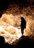
Climb down the next obstacle to arrive at the crux of the canyon: a stunning 160 foot rappel into a deep, rounded, red canyon chamber. This rappel is from a dead-man anchor; check it carefully before rappelling. The rappel is more moderate to the rappeler's right. Following the water to the left for a shorter, free hanging rappel. You can make it to the ground to rappeler's left in ~150 feet. It's a full 160' to the water following on the rappeler's right.

(A word to the wise: while it's possible to complete this rap with two 60 meter dynamic climbing ropes, pulling 200' of wet 10.2mm rope is unpleasant, at best. You'll be much happier with proper static canyoneering rope.)

The 160' rap is followed immediately by a small downclimb and another short 15' rappel.

A short rappel or jump follows. Two small downclimbs bring you to a slick 50' (two section) rappel. You can anchor from a large tree (with increased risk of getting your rope caught), or a worryingly small chockstone. Check this thoroughly during times of high water flow and/or recent rains to ensure its security.

Next, you will encounter three easy downclimbs, followed by two bigger downclimbs. The larger downclimbs can be done on canyon-right. Alternatively, run a rope over the tree on canyon-right to rappel the 10' down the first larger downclimb.

The canyon finishes with a 30' rappel off a large chockstone down a chute, followed by a 25' rappel (above what may be the eponymous Shake Tree) into clear water fed by a stream from the south.

Continue downstream for another 50 years or so, and exit canyon-left up a water-worn gully. As the gully widens, head north to the top of the ridge, then west on top of the ridge to rejoin the Y Bar trail.

Suggested equipment: 1x 350' rope, 1x 110' rope, 40 feet of webbing, rap rings.

Based on Vaporman's post, there's more water in the spring (edit: confirmed by Occam79. This is NOT a spring route). During the summer months the water is limited (there's usually one short, mandatory swim) and you can comfortably leave your wetsuit behind. That said, there was still a slow trickle in most pools which afforded clean, beautiful and very clear pools (with one, obvious exception).
_____________________
 
Mar 12 2011
avatar

 Guides 3
 Routes 4
 Photos 8,687
 Triplogs 931

46 male
 Joined Mar 28 2005
 Gilbert, AZ
Shake Tree CanyonPayson, AZ
Payson, AZ
Canyoneering avatar Mar 12 2011
VapormanTriplogs 931
Canyoneering5.00 Miles 3,000 AEG
Canyoneering5.00 Miles   7 Hrs   20 Mns   0.68 mph
3,000 ft AEG
Intermediate Canyoneering - Difficult or dangerous; Tech Climb; rope reqd; descent anchor; exit technical;
C - Strong current; wading/swimming; waterfalls; possible wet/dry suit
III - Normally requires most of a day
 no routes
1st trip
Linked   linked  
Partners partners
azrocketchick
SparkyJackie
Last minute moderate canyon trip thrown together because a BIG canyon trip up north just couldn't be thrown together in time...

We started from the Barnhardt TH and hiked the Y Bar trail 2 or so miles and dropped into Shake Tree Canyon just above the cliffband and the canyon drops into an obvious narrows. :sweat: The sweet narrows starts off with two shorts drops of 20ft or so and some light down climbing before arriving at the big boy. Either a tricky down climb or short 10ft rappel gets you to a deadman anchor for the freaking awesome 160ft angled rappel down a curved chute which drops you into a beautiful section of the canyon. :y: Just below the big falls, a slick down climb put you at a short 10ft waterfall rappel and just around the corner is another optional rappel or slick down climb and/or jump in a pool. Just around the corner from that is a slick 50ft double drop waterfall rappel with some more down climbing past that. We found a nice sunny place to warm up and take a lunch break down in there while soaking in the amazing canyon views & sunshine. :D After that we hit a 50ft rappel #7 around a huge chockstone down a chute into a pool with a short drop below that with rappel #8 just beyond that, which was a 25ft slick falls. The technical section ended soon afterwards and it got thickly vegetated real fast, but we dropped our gear and hiked up a side drainage on the left back up to the ridge and trail above. :sweat: From there it was just another 2 or so easy trail miles back to the Barnhardt TH.

Such a great moderate waterfall canyon, that's good for experienced canyon hikers that haven't done any waterfall rappels before. :D
_____________________
Yea, canyoneering is an extreme sport... EXTREMELY dramatic!!! =p
 
Mar 12 2011
avatar

 Guides 13
 Triplogs 205

38 female
 Joined Jan 29 2009
 Murray, UT
Shake Tree CanyonPayson, AZ
Payson, AZ
Canyoneering avatar Mar 12 2011
SparkyJackieTriplogs 205
Canyoneering5.00 Miles 3,000 AEG
Canyoneering5.00 Miles   7 Hrs   20 Mns   0.68 mph
3,000 ft AEG
 no routesno photosets
1st trip
Linked   none no linked trail guides
Partners none no partners
_____________________
  1 archive
Mar 12 2011
avatar

 Triplogs 3

42 female
 Joined May 10 2011
 Chandler, AZ
Shake Tree CanyonPayson, AZ
Payson, AZ
Canyoneering avatar Mar 12 2011
azrocketchickTriplogs 3
Canyoneering5.00 Miles 3,000 AEG
Canyoneering5.00 Miles   5 Hrs      1.00 mph
3,000 ft AEG15 LBS Pack
 no routesno photosets
1st trip
Linked   none no linked trail guides
Partners none no partners
_____________________
 
average hiking speed 0.93 mph

WARNING! Hiking and outdoor related sports can be dangerous. Be responsible and prepare for the trip. Study the area you are entering and plan accordingly. Dress for the current and unexpected weather changes. Take plenty of water. Never go alone. Make an itinerary with your plan(s), route(s), destination(s) and expected return time. Give your itinerary to trusted family and/or friends.

helpcommentissue

end of page marker