username
X
password
register
for free!
help
ArticlesGuidesRoutes
 
Photosets
 
 Comments
triplogs   photosets   labels comments more
Mount Ord from Slate Creek TH - 44 members in 297 triplogs have rated this an average 3.5 ( 1 to 5 best )
1, 2, 3, 4, 5 ... 15  Next
297 triplogs
login for filter options
Apr 22 2025
avatar

 Guides 10
 Routes 673
 Photos 7,281
 Triplogs 4,660

67 female
 Joined Nov 17 2008
 phoenix, az
Mount Ord from Slate Creek THPayson, AZ
Payson, AZ
Hiking avatar Apr 22 2025
trekkin_geckoTriplogs 4,660
Hiking15.40 Miles 4,020 AEG
Hiking15.40 Miles   4 Hrs   48 Mns   3.40 mph
4,020 ft AEG      16 Mns Break
 
Linked   none no linked trail guides
Partners partners
johnlp
john and i got going around 0600
cool temps and quite a bit of shade on the ascent
we took a snack break at the top
good views to the north, hazy elsewhere
did not go up the tower because workers were watching
penstemon, a couple globemallow, one indian paintbrush, some yellow flowers
saw a couple of rabbits and a hawk on the way down
saw one other hiker
na beers after and dj's for lunch
good hike, thanks john
wildflower observationwildflower observationwildflower observationwildflower observationwildflower observation
Wildflowers Observation Isolated
_____________________
hazhole
  2 archives
Apr 22 2025
avatar

 Guides 1
 Routes 14
 Photos 7,202
 Triplogs 5,208

68 male
 Joined Mar 16 2008
 chandler,az
Mount Ord from Slate Creek THPayson, AZ
Payson, AZ
Hiking avatar Apr 22 2025
johnlpTriplogs 5,208
Hiking15.40 Miles 4,020 AEG
Hiking15.40 Miles   4 Hrs   48 Mns   3.40 mph
4,020 ft AEG      16 Mns Break
 no routes
Linked   none no linked trail guides
Partners partners
trekkin_gecko
Kelly suggested hiking Ord. Why not?
We got an early start, considering the drive, at 6 AM. Nice and cool. Shaded much of the way up which is always nice. Very little breeze.
We took a snack break up top. There were a bunch of guys working on the communications equipment.
Kelly kept a good pace both up and down. The miles passed quickly.
Refreshments, lunch, and home. Great day. Thanks Kelly! :)
wildflower observationwildflower observationwildflower observationwildflower observationwildflower observation
Wildflowers Observation Isolated
_____________________
“Good people drink good beer.” Hunter S Thompson
 
Apr 13 2025
avatar

 Routes 596
 Photos 9,604
 Triplogs 2,400

58 male
 Joined Jan 30 2011
 Chandler, AZ
Mount Ord from Slate Creek THPayson, AZ
Payson, AZ
Hiking avatar Apr 13 2025
JuanJaimeiiiTriplogs 2,400
Hiking15.50 Miles 4,108 AEG
Hiking15.50 Miles   4 Hrs   29 Mns   3.46 mph
4,108 ft AEG
 
Linked   none no linked trail guides
Partners none no partners
Sky was overcast when I started a little after 10:20. Once I reached 626 it started to get windy and remained that way until I reached the top. Then it was pretty much sunny the majority of the way down. Saw about four or five other hikers and two people on mountain bikes. I’m glad that big ditch is gone.
_____________________
 
Mar 03 2025
avatar

 Triplogs 1

male
 Joined Feb 03 2023
 Phoenix, Arizona
Mount Ord from Slate Creek THPayson, AZ
Payson, AZ
Hiking avatar Mar 03 2025
apim11Triplogs 1
Hiking15.50 Miles 4,108 AEG
Hiking15.50 Miles
4,108 ft AEG
 no routesno photosets
1st trip
Linked   none no linked trail guides
Partners none no partners
Reporting good spring water

water 1 out of 5water 2 out of 5water less than maxwater less than max Calcord Springs Quart per minute Quart per minute
Water steadily trickling and the tank was full. Filled up 6+ liters for our group with no noticeable difference to the tank.
  1 archive
Feb 03 2025
avatar

 Guides 99
 Routes 1,484
 Photos 16,072
 Triplogs 1,374

male
 Joined Jan 07 2017
 Fountain Hills,
Mount Ord from Slate Creek THPayson, AZ
Payson, AZ
Hiking avatar Feb 03 2025
DixieFlyerTriplogs 1,374
Hiking15.56 Miles 3,950 AEG
Hiking15.56 Miles   7 Hrs   53 Mns   2.48 mph
3,950 ft AEG   1 Hour   36 Mns Break
 
Linked   none no linked trail guides
Partners none no partners
Route Scout Route Recorded  on Route Scout | Pop | Map | Popup | MapDEX
I decided to get out of the heat in the Valley and head up to Mount Ord. This is the first time since last spring that I did the hike from the Slate Creek TH.

It was cool at the early morning start, but by the time I got to the summit I was wishing that I was in a t-shirt and shorts.

There was a bit of snow in the usual spots (on shaded north facing slopes), but not enough to merit the use of traction devices.
 Meteorology
 Meteorology [ checklist ]
[ checklist ]  Snow
_____________________
Civilization is a nice place to visit but I wouldn't want to live there
  1 archive
Dec 30 2024
avatar

 Guides 110
 Routes 2,246
 Photos 8,982
 Triplogs 2,600

45 female
 Joined Dec 24 2007
 Ahwatukee, AZ
Mount Ord from Slate Creek THPayson, AZ
Payson, AZ
Hiking avatar Dec 30 2024
LindaAnnTriplogs 2,600
Hiking15.40 Miles 3,939 AEG
Hiking15.40 Miles   6 Hrs   8 Mns   2.66 mph
3,939 ft AEG      21 Mns Break
 
Linked   none no linked trail guides
Partners partners
danielac
Route Scout Route Recorded  on Route Scout | Pop | Map | Popup | MapDEX
Daniela’s choice of hike today, I told her anything would be fine with me. We got started around 0715. Cool temps, but no wind. Made decent time uphill, but we were both tired on the final mile to the summit. Took a break up top, then headed back down. Warmed up along the way.

Saw one other hiker, and a few vehicles. The old road is in rough shape, but still driveable with a capable vehicle, as we saw two Jeeps in the lower section. The upper road looks like it was graded earlier this year. It’s a very ORDinary hike, but easy stats. I had told Daniela yesterday that if we left the carpool lot at 0600, I would have her back by 1445, since I figured we’d take about six hours for the hike. True to my word, we got back at 1435.
_____________________
Stop crying and just go do the hike.
 
Oct 06 2024
avatar

 Routes 39
 Photos 64
 Triplogs 42

58 male
 Joined Mar 29 2015
 Chandler, AZ
Hike Mt Ord backside, AZ 
Hike Mt Ord backside, AZ
 
Hiking avatar Oct 06 2024
AndrewrdcTriplogs 42
Hiking11.79 Miles 3,008 AEG
Hiking11.79 Miles   5 Hrs   17 Mns   2.53 mph
3,008 ft AEG      37 Mns Break15 LBS Pack
 
no photosets
1st trip
Linked   linked  
Partners none no partners
Route Scout Route Recorded  on Route Scout | Pop | Map | Popup | MapDEX
Started my hike at 7:45am and there was only 1 other car in the parking lot. Took about 5 hours to hike the 12 miles. Weather should be cooling down soon, but I needed a break from the heat right now. Decided to give this trail a shot as it gets pretty high (ie cool) most of the way.

Great hike up the back (north) side of Mt Ord. This is basically a 4x4 trail (FR27) that intersects with the main road up Mt Ord (NF-626) about 5-miles up. Once there, turn left along 626 and you can get to the top. At about the 6mile mark, you get into the pine trees and this was what I was looking for as a break from the valley heat. I found a nice area, hiked about 60 yards into the pines, set up my hammock and took a nap…. Ahhhh!

Got back to my car at 1pm… last 2 miles was over 100 degrees, but was not too bad with the breeze. Had the trail to myself except for one mountain biker and one pick-up truck full of hunters.

Great day!
_____________________
 
Sep 28 2024
avatar

 Routes 13
 Photos 162
 Triplogs 15

male
 Joined Jul 22 2023
 
Mount Ordinary, AZ 
Mount Ordinary, AZ
 
Hiking avatar Sep 28 2024
JamesPTriplogs 15
Hiking17.05 Miles 4,671 AEG
Hiking17.05 Miles   5 Hrs   2 Mns   3.58 mph
4,671 ft AEG      16 Mns Break20 LBS Pack
 
no photosets
1st trip
Linked   linked  
Partners none no partners
Route Scout Route Recorded  on Route Scout | Pop | Map | Popup | MapDEX
Friends were heading to the Weatherford trail in the Kachina Peaks but I have a busy weekend and don't mind the heat much. I was out the door by 415am, stopped for an overpriced breakfast burrito and head out for Slate Creek trail. Arrived by 515 and on trail at 530am. I describe this trail as "Ordinary" cause I think it's clever, you know, cause of Ord and because it's another triple wide FR that must have been turned from a trail to a road by the miners once upon a time. This reminded me a lot of Reavis Ranch 109 from the North to Lime MTN. Of course, Ord has a bit more AEG. Nice to see pines. The trail was in shadow almost the entire morning but it got hot on the way down. Also, it's ordinary because all types access the top, hikers, trail runners, motorcycles, side x sides, jeeps, you get the idea. I did Browns a couple weeks ago so nice to look back at it from the North. I am itching to do Mazzy Peak now and I imagine it will be the most difficult of the three.
wildflower observationwildflower observationwildflower observationwildflower observationwildflower observation
Wildflowers Observation Isolated
Those little blue daisies I think, up high, in the shade
  1 archive
Jun 22 2024
avatar

 Guides 27
 Routes 669
 Photos 12,096
 Triplogs 856

56 male
 Joined Jul 05 2006
 Mesa, AZ
Mount Ord from Slate Creek THPayson, AZ
Payson, AZ
Hiking avatar Jun 22 2024
DarthStillerTriplogs 856
Hiking15.56 Miles 3,949 AEG
Hiking15.56 Miles   7 Hrs   5 Mns   2.35 mph
3,949 ft AEG      28 Mns Break
 
Linked   none no linked trail guides
Partners partners
adilling
wallyfrack
Back to Ord again for a final training hike. I got Andy and Wally to join me this time, probably because of the heat and humidity taking over the valley. We had left the idea open to do little Ord to mix things up, but I decided to just to Ord again.

The first mile or 2 the sun was breaking through the clouds, which didn't help. As we ascended, the clouds took over and the temperature got cooler, which did help. I passed Andy right at the 3 mile mark, and from then on he was falling back farther and farther. I stayed and waited before a switchback when there was a long view to see if he made the previous turn, which he did all along FR27.

Once I got to 626, I got my second wind again. The smoother grade of the road and it being less steep right at the junction helps a lot. As the road got steep towards the summit, I was able to keep my same pace. Andy was way back, Wally was napping at the summit.

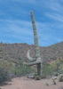
It was very windy and cool at the summit, after a while I almost got a chill, which I had no problem with. Got the obligatory shot at the top of Wally pointing out Mount Ord :lol: . No sign of Andy after 20 minutes so I took my phone out of airplane mode to see if he texted, which he did. He was having too much trouble going uphill, so after a quarter mile on 626, he bailed. He went the wrong way on 626, so that might have had something to do with it. I would have bailed, too. Still got over 3K' for the day, so not a wasted day by any means.

Leaving the summit, Wally spotted 2 deer, which we managed to get a few shots of. Normally they just run off immediately, but these ones hung around for a photo shoot. On the way down Wally and I passed Andy with about 3 miles to go. I made better time going downhill this time. My overall time was about 30 minutes better than 3 months ago. I remember the last 1.5 miles last time my knee and back were bothering me. This time was much better.

Stopped at the mill again to check out the 2 big prospect holes on the side of the hill. Not much to see up close. the road above them went further out, but I decided to call it day. It's very interesting when you get further away from this site and you can see the prospects and tailings piles below and the chutes below them for what's left of the mining operations there. The clouds made for less dramatic pictures but it really saved us from the heat, even though it was still humid.
_____________________
 
Jun 22 2024
avatar

 Guides 2
 Routes 267
 Photos 9,816
 Triplogs 402

62 male
 Joined Dec 02 2014
 Mesa, AZ
Mount Ord from Slate Creek THPayson, AZ
Payson, AZ
Hiking avatar Jun 22 2024
adillingTriplogs 402
Hiking11.49 Miles 2,953 AEG
Hiking11.49 Miles   7 Hrs   9 Mns   1.94 mph
2,953 ft AEG   1 Hour   13 Mns Break
 
1st trip
Linked   none no linked trail guides
Partners none no partners
Route Scout Route Recorded  on Route Scout | Pop | Map | Popup | MapDEX
Chris has been after me to join him on one of this torture hikes. I finally agreed to join him and Wally to hit Mt Ord. I have only been up to the top once before. That was via a truck. I think the drive up is a little more relaxing that the hike up.

The cooler temps and cloud cover made the heat tolerable, but the humidity was pretty rough going up the first couple miles. I was ready for the gradual climb up the "road" on FS27. It had a few rough spots from erosion, and it doesn't look like it gets much vehicle traffic. The damage from the fires was still very evident at the lower elevations. Lots of crispy tree skeletons and that strange green bushy stuff that shows up after fires.

I started feeling the elevation gain about mile 3. My heart would start racing at an uncomfortable rate. So, I would stop for a little and then start up again, a little slower. That worked ok until about a mile from the FS27 and FS626. I was really moving slow.

My legs and lungs felt ok, I was just feeling that crazy heartrate. I made it to the junction, and of course, when right when I should have gone left. I eventually figured it out when it just kept going down. I turned around and made it about 1/2 mile up and the heart rate started to go up and up. I finally stopped and just rested for about 30 minutes. Had a little food and drank some electrolytes. I contemplated starting up again, but if my speed remained as before, it would take me a while to make it to the top. I threw in the towel and sent Chris a message and started back down.

I did much better with gravity as my friend on the way down. But, I was still slower than Chris and Wally who passed me by on the way down.

I have not had an experience like this before. I am guessing it's because I haven't done a serious elevation hike in a while and I am out of shape. Although, round is a shape. We will see. I will come back to this trail in the fall when the temps drop. And give it another try after losing a little weight and doing tougher hikes in the interim.

Either way, it was a good exercise day. Almost 12 miles and 3000 ft of aeg. That's much more than I have been doing lately for sure. Plus, it's always good hiking with Chris and Wally.
_____________________
"Jobs fill your pockets, adventures fill your soul."

instagram: @andydilling
 
Jun 22 2024
avatar

 Routes 93
 Photos 7,758
 Triplogs 1,691

64 male
 Joined Mar 11 2003
 AZ
Mount Ord from Slate Creek THPayson, AZ
Payson, AZ
Hiking avatar Jun 22 2024
wallyfrackTriplogs 1,691
Hiking15.56 Miles 3,949 AEG
Hiking15.56 Miles   7 Hrs   5 Mns   2.35 mph
3,949 ft AEG      28 Mns Break
 
Linked   none no linked trail guides
Partners partners
adilling
DarthStiller
Another hike in the books. We started early but the sun was up and it was warm for a little while until the clouds did their job. The grade seemed easy at first after that past few weeks of steep climbs. The humidity was up and my clothes were just plain wet. I paused and rested a few times but Chris and Andy were a little farther back so I didn't see anyone until Chris made it to the top. The wind was blowing up top and it was cool enough for jacket. Chris told me Andy turned back so after our lunch break we headed down. Chris was moving faster than usual. Stopped to change GPS batteries and ended up in the back for a while. The breeze kept it nice for a bit but it did get toasty at the end of the hike. Another good work out now it time for some slacking until the weather cools down.
 Culture
 Culture [ checklist ]
[ checklist ]  Reference Mark
_____________________
  3 archives
May 23 2024
avatar

 Guides 99
 Routes 1,484
 Photos 16,072
 Triplogs 1,374

male
 Joined Jan 07 2017
 Fountain Hills,
Mount Ord from Slate Creek THPayson, AZ
Payson, AZ
Hiking avatar May 23 2024
DixieFlyerTriplogs 1,374
Hiking15.36 Miles 3,988 AEG
Hiking15.36 Miles   7 Hrs   19 Mns   2.39 mph
3,988 ft AEG      54 Mns Break
 
Linked   none no linked trail guides
Partners none no partners
Route Scout Route Recorded  on Route Scout | Pop | Map | Popup | MapDEX
When it comes to wildflowers, hiking to Mount Ord is the gift that keeps on giving. Some of the flowers at the lower elevations have dried out, but there was something blooming most of the way from the trailhead to the summit.
 Named place
 Named place [ checklist ]
[ checklist ]  Bartlett Reservoir
wildflower observationwildflower observationwildflower observationwildflower observationwildflower observation
Wildflowers Observation Moderate
Field bindweed and sand wash groundsel won the wildflower derby today, but there was lots of yerba santa and deer brush also.
_____________________
Civilization is a nice place to visit but I wouldn't want to live there
 
May 02 2024
avatar

 Guides 99
 Routes 1,484
 Photos 16,072
 Triplogs 1,374

male
 Joined Jan 07 2017
 Fountain Hills,
Mount Ord from Slate Creek THPayson, AZ
Payson, AZ
Hiking avatar May 02 2024
DixieFlyerTriplogs 1,374
Hiking15.45 Miles 3,988 AEG
Hiking15.45 Miles   7 Hrs   21 Mns   2.36 mph
3,988 ft AEG      48 Mns Break
 
Linked   none no linked trail guides
Partners none no partners
Route Scout Route Recorded  on Route Scout | Pop | Map | Popup | MapDEX
I decided to escape the VOS today and hike up to Mount Ord.

There are still some decent wildflowers in places, but overall the flowers are not as good as last year.
wildflower observationwildflower observationwildflower observationwildflower observationwildflower observation
Wildflowers Observation Moderate
Globemallow won the wildflower derby today, with field bindweed, fleabance, and a couple of others also having good showings.
_____________________
Civilization is a nice place to visit but I wouldn't want to live there
 
Apr 24 2024
avatar

 Guides 99
 Routes 1,484
 Photos 16,072
 Triplogs 1,374

male
 Joined Jan 07 2017
 Fountain Hills,
Mount Ord from Slate Creek THPayson, AZ
Payson, AZ
Hiking avatar Apr 24 2024
DixieFlyerTriplogs 1,374
Hiking15.49 Miles 3,988 AEG
Hiking15.49 Miles   7 Hrs   29 Mns   2.41 mph
3,988 ft AEG   1 Hour   3 Mns Break
 
Linked   none no linked trail guides
Partners none no partners
Route Scout Route Recorded  on Route Scout | Pop | Map | Popup | MapDEX
I went to bed last night intending to hike close to home in the McDowells this morning, but when I got up it felt like a good day for a hike to Ord, so I made a beeline for the Slate Creek TH.

Wildflowers were decent for about the first 3 miles or so of FR 27.
 Named place
 Named place [ checklist ]
[ checklist ]  Mogollon Rim
wildflower observationwildflower observationwildflower observationwildflower observationwildflower observation
Wildflowers Observation Moderate
Arizona penstemon won the wildflower derby today, with purple nightshade and globemallow also putting on a good show. A few other flowers had their moments also.
_____________________
Civilization is a nice place to visit but I wouldn't want to live there
 
Apr 24 2024
avatar

 Guides 59
 Routes 1,100
 Photos 1,191
 Triplogs 1,290

male
 Joined Jan 01 2023
 Arizona
Mount Ord from Slate Creek THPayson, AZ
Payson, AZ
Hiking avatar Apr 24 2024
pseudalpineTriplogs 1,290
Hiking17.45 Miles 4,563 AEG
Hiking17.45 Miles   6 Hrs   15 Mns   3.13 mph
4,563 ft AEG      40 Mns Break
 
no photosets
Linked   linked  
Partners none no partners
Route Scout Route Recorded  on Route Scout | Pop | Map | Popup | MapDEX
Not sure why Dese and I repeated these two mediocre summits. :-k
  8 archives
Apr 11 2024
avatar

 Guides 99
 Routes 1,484
 Photos 16,072
 Triplogs 1,374

male
 Joined Jan 07 2017
 Fountain Hills,
Mount Ord from Slate Creek THPayson, AZ
Payson, AZ
Hiking avatar Apr 11 2024
DixieFlyerTriplogs 1,374
Hiking15.35 Miles 3,988 AEG
Hiking15.35 Miles   6 Hrs   36 Mns   2.64 mph
3,988 ft AEG      47 Mns Break
 
Linked   none no linked trail guides
Partners none no partners
Route Scout Route Recorded  on Route Scout | Pop | Map | Popup | MapDEX
I decided to head up to Mount Ord today and get a little exercise.

Wildflowers are still a little light, but it is early in the season yet. I expect that wildflowers will be much better in two weeks.

Normally I don't see anyone else on this hike, but there were a few people hiking up to Ord today

FR 626 is now dry and completely snow-free, although there are a still a few small patches of snow on the upper slopes of Mount Ord.
 Named place
 Named place [ checklist ]
[ checklist ]  Four Peaks
wildflower observationwildflower observationwildflower observationwildflower observationwildflower observation
Wildflowers Observation Light
There were some wildflowers from the TH to a little past Jaws, but none beyond that. Western Wallflower won the wildflower derby today.
_____________________
Civilization is a nice place to visit but I wouldn't want to live there
 
Mar 30 2024
avatar

 Guides 27
 Routes 669
 Photos 12,096
 Triplogs 856

56 male
 Joined Jul 05 2006
 Mesa, AZ
Mount Ord from Slate Creek THPayson, AZ
Payson, AZ
Hiking avatar Mar 30 2024
DarthStillerTriplogs 856
Hiking15.78 Miles 4,179 AEG
Hiking15.78 Miles   7 Hrs   32 Mns   2.22 mph
4,179 ft AEG      26 Mns Break
 
Linked   none no linked trail guides
Partners none no partners
I did this hike last almost exactly 11 years ago. Continued with my trend of more vertical hikes to get in training for my big summer hike plans. The rocky sections of FR27 slowed me down a bit, but it wasn't too bad. It felt kind of warm when I started, but it quickly got cooler as I ascended the road. Things got easier on FR626 to the summit, but there was still a good bit of elevation gain to go. I was feeling it a little by the time I got to the summit and I was very ready for lunch.

Ate lunch by the CCC cabin on the retaining wall to hide from the wind. After lunch I checked out all the towers and the area in general. Spotted the SF Peaks looking north and various landmarks to the south.

On the way down I checked out the original Ord Mine mill. I spotted some maybe abandoned mine shafts on my way up after I passed them, but I couldn't find them again on the way back down to try to check them out closer. Interesting to read some of the history of this area and then see it while I was out there. Felt very sore at the end of the hike since I only took the one lunch break, but later in the evening I felt fine.
_____________________
 
Mar 21 2024
avatar

 Guides 99
 Routes 1,484
 Photos 16,072
 Triplogs 1,374

male
 Joined Jan 07 2017
 Fountain Hills,
Mount Ord from Slate Creek THPayson, AZ
Payson, AZ
Hiking avatar Mar 21 2024
DixieFlyerTriplogs 1,374
Hiking15.45 Miles 3,991 AEG
Hiking15.45 Miles   7 Hrs   8 Mns   2.48 mph
3,991 ft AEG      54 Mns Break
 
Linked   none no linked trail guides
Partners none no partners
Route Scout Route Recorded  on Route Scout | Pop | Map | Popup | MapDEX
I got up this morning intending to hike close to home in the McDowells, but at the last minute I decided to make a beeline to the Slate Creek TH and hike up to Ord.

There were some wildflowers blooming along FR27, but there won't be a lot of flowers until April.

There was no snow left on the road, so that was not an issue on the hike.

This was the first time that I had hiked on FR27 since last June. It seems that the burn scar from the Bush fire has healed, so FR27 does not seem to have gotten more eroded since I was there last.
wildflower observationwildflower observationwildflower observationwildflower observationwildflower observation
Wildflowers Observation Isolated
There are a few flowers blooming, but it will be April before you start seeing an abundance of flowers on this hike.
_____________________
Civilization is a nice place to visit but I wouldn't want to live there
 
Nov 25 2023
avatar

 Guides 110
 Routes 2,246
 Photos 8,982
 Triplogs 2,600

45 female
 Joined Dec 24 2007
 Ahwatukee, AZ
Mount Ord from Slate Creek THPayson, AZ
Payson, AZ
Hiking avatar Nov 25 2023
LindaAnnTriplogs 2,600
Hiking16.96 Miles 4,053 AEG
Hiking16.96 Miles   6 Hrs   32 Mns   2.74 mph
4,053 ft AEG      20 Mns Break
 
Linked   none no linked trail guides
Partners none no partners
Route Scout Route Recorded  on Route Scout | Pop | Map | Popup | MapDEX
Good workout to burn off some calories. Got started before 0800. The road from 2.50-5.00 miles is kind of rough, but still decent hiking. It obviously rained last night, which softened the ground a bit. Saw a handful of hikers above the junction with the main road. Some snow/graupel on the ground for the upper half mile or so. Chatted with two guys working at the top, according to them it was 35 degrees. Wandered around a little on the way back down. Saw one deer. Cool temps with a nice breeze most of the way. The final two miles felt warm, but it was 55 when I finished.
_____________________
Stop crying and just go do the hike.
 
Sep 23 2023
avatar

 Routes 93
 Photos 7,758
 Triplogs 1,691

64 male
 Joined Mar 11 2003
 AZ
Mount Ord from Slate Creek THPayson, AZ
Payson, AZ
Hiking avatar Sep 23 2023
wallyfrackTriplogs 1,691
Hiking15.50 Miles 4,108 AEG
Hiking15.50 Miles   5 Hrs   12 Mns   2.98 mph
4,108 ft AEG
 
Linked   none no linked trail guides
Partners none no partners
A trip to Wade's World. The start wasn't as cool as expected because of the cloud cover but the cloud cover kept it from warming up later so that was good. There were several hikers out. The ones I talked to were training for the Grand Canyon of course. Wasn't sure how I'd feel on this hike after mostly easy 9 mile trips or less but my legs held up. I ran into hikerdw near the top. It was good to see him and we stopped talked a bit. There were some light sprinkles for a little while. Just enough to keep you cool. The views were hazy because of the low clouds but that made for a nice change. A few 4X4 were driving up FR27 when I had about a mile left. Not sure how they did. A good workout to get ready for the cooler weather.
_____________________
  3 archives
average hiking speed 2.47 mph
1, 2, 3, 4, 5 ... 15  Next

WARNING! Hiking and outdoor related sports can be dangerous. Be responsible and prepare for the trip. Study the area you are entering and plan accordingly. Dress for the current and unexpected weather changes. Take plenty of water. Never go alone. Make an itinerary with your plan(s), route(s), destination(s) and expected return time. Give your itinerary to trusted family and/or friends.

helpcommentissue

end of page marker