username
X
password
register
for free!
help
ArticlesGuidesRoutes
 
Photosets
 
 Comments
triplogs   photosets   labels comments more
Keystone Peak - 7 members in 19 triplogs have rated this an average 3.4 ( 1 to 5 best )
19 triplogs
login for filter options
Nov 20 2024
avatar

 Guides 99
 Routes 1,484
 Photos 16,072
 Triplogs 1,374

male
 Joined Jan 07 2017
 Fountain Hills,
Keystone PeakTucson, AZ
Tucson, AZ
Hiking avatar Nov 20 2024
DixieFlyerTriplogs 1,374
Hiking8.62 Miles 1,638 AEG
Hiking8.62 Miles   3 Hrs   52 Mns   2.60 mph
1,638 ft AEG      33 Mns Break
 
1st trip
Linked   none no linked trail guides
Partners none no partners
Route Scout Route Recorded  on Route Scout | Pop | Map | Popup | MapDEX
After doing some messy bushwhacking on a hike the day before, I was looking for a hike on a road/trail and Keystone Peak, aka Mount Ord South, fit the bill.

This was a hike on a well graded road all the way from the TH to the summit. There was nice scenery along the way, making for an enjoyable stroll.

There was a MacLilley register at the summit, along with a park bench to sit on and enjoy the views.

This was the second time that I have done this hike, and if I lived in the area I imagine that I would hike it a time or two a month.
_____________________
Civilization is a nice place to visit but I wouldn't want to live there
 
Feb 27 2024
avatar

 Guides 93
 Routes 397
 Photos 4,984
 Triplogs 4,124

49 male
 Joined Jun 20 2003
 Tucson, AZ
Keystone PeakTucson, AZ
Tucson, AZ
Hiking avatar Feb 27 2024
fricknaleyTriplogs 4,124
Hiking8.60 Miles 1,703 AEG
Hiking8.60 Miles   2 Hrs   49 Mns   3.37 mph
1,703 ft AEG      16 Mns Break7 LBS Pack
 
Linked   none no linked trail guides
Partners none no partners
Several years since I was last out here. Didn't see anyone other than some deer. Breezy and cool day. The views are as wonderful as ever. Nice quick summit that I should visit more often. Kind of a pleasant drive out there too.
_____________________
hi
 
Nov 28 2023
avatar

 Routes 3
 Photos 9
 Triplogs 4

62 male
 Joined Feb 25 2013
 Tucson, AZ
Keystone PeakTucson, AZ
Tucson, AZ
Hiking avatar Nov 28 2023
namasteronTriplogs 4
Hiking8.40 Miles 1,684 AEG
Hiking8.40 Miles   3 Hrs   7 Mns   2.70 mph
1,684 ft AEG
 no routes
1st trip
Linked   none no linked trail guides
Partners none no partners
A very good easy/moderate hike especially to get your dogs some exercise. Always deer and cows along the way and today wasn't different. Great views the whole way of hills and valleys and then panoramic at the top with great views of Kitt, Baboquivari, Wrightson and Hopkins. You break the trip up (kind of) into 1.3 miles section 1) big portion of the climb to the intersection of trails/roads 2) to the little cabin complete with picnic table and rope swing 3) traverse that gets you to the last climb to the towers.
 Fauna
 Fauna [ checklist ]
[ checklist ]  Tarantula
_____________________
 
Apr 11 2021
avatar

 Guides 2
 Routes 10
 Photos 42
 Triplogs 893

58 male
 Joined Jul 12 2012
 Oro Valley, AZ
Keystone PeakTucson, AZ
Tucson, AZ
Hiking avatar Apr 11 2021
SpiderLegsTriplogs 893
Hiking8.40 Miles 1,600 AEG
Hiking8.40 Miles   3 Hrs   30 Mns   2.40 mph
1,600 ft AEG
 no routesno photosets
1st trip
Linked   none no linked trail guides
Partners partners
Jim
This one has been on my radar for about a year, was intrigued by a lesser known peak that nobody goes to. Plus a lot of Arizona history here. Convinced Jim to tag along and we took a mellow stroll up to the top. The trail can best be described as climbing Shaw Butte via the service road, but for 4.2 miles to the top. Along the way did notice lots of game trails and trails used for rounding up cattle. Potentially a bit more to explore back here.

Surprised that something within 45 minutes of my house starts at 4700 feet of elevation and there are no crowds. This would be a good training hike or run. But for scenery I'd drive the extra 15 minutes to Madera Canyon.
_____________________
See my pics on Instagram @tucsonexplorer
 
Apr 11 2021
avatar

 Guides 73
 Routes 176
 Photos 10,174
 Triplogs 2,324

46 male
 Joined Sep 08 2006
 
Keystone PeakTucson, AZ
Tucson, AZ
Hiking avatar Apr 11 2021
JimTriplogs 2,324
Hiking8.40 Miles 1,600 AEG
Hiking8.40 Miles
1,600 ft AEG10 LBS Pack
 no routesno photosets
1st trip
Linked   none no linked trail guides
Partners partners
SpiderLegs
Taking in a summit that was off my radar until James said he wanted to hike it. Not bad, but very dry right now and spring is only beginning. I didn't bother with any photos due to the overcast and gray. Views are good here, but you want a really good day to enjoy them.

Nice hike.

water 1 out of 5water less than maxwater less than maxwater less than max Keystone Tank 1-25% full 1-25% full
_____________________
🍭
 
Dec 11 2020
avatar

 Routes 596
 Photos 9,604
 Triplogs 2,400

58 male
 Joined Jan 30 2011
 Chandler, AZ
Keystone PeakTucson, AZ
Tucson, AZ
Hiking avatar Dec 11 2020
JuanJaimeiiiTriplogs 2,400
Hiking9.60 Miles 2,033 AEG
Hiking9.60 Miles   3 Hrs   10 Mns   3.29 mph
2,033 ft AEG      15 Mns Break
 no routes
1st trip
Linked   linked  
Partners partners
azdesertfather
I have been long overdue for a hike with "Father Dave". We have been trying to connect but life seems to get in the way. Finally the stars lined up and he suggested this one. It follows a dirt road up to the towers and then you are rewarded with some great views. It reminded me of a smaller version of Mount Ord. We hit a couple other peaks while there and then back to where we had started. Enjoyable hike in an area that I was completely unfamiliar with. Great catching up with Dave as well.
_____________________
 
Dec 11 2020
avatar

 Guides 16
 Routes 81
 Photos 1,269
 Triplogs 1,144

51 male
 Joined Apr 30 2008
 Tucson, AZ
Keystone PeakTucson, AZ
Tucson, AZ
Hiking avatar Dec 11 2020
azdesertfatherTriplogs 1,144
Hiking9.60 Miles 2,033 AEG
Hiking9.60 Miles   3 Hrs   10 Mns   3.29 mph
2,033 ft AEG      15 Mns Break
 
no photosets
1st trip
Linked   linked  
Partners partners
JuanJaimeiii
Route Scout Route Recorded  on Route Scout | Pop | Map | Popup | MapDEX
One of my few remaining Tucson peaks, pretty rewarding. Nice views at about 6200’, able to hit three of the top peaks at once there plus take in some of the local culture, like the cabin on the way up. JJ and I had a great time. We were pretty intrigued by Helmet Head Mtn nearby, but as we Che led it out saw that it was fenced off entirely with ASARCO private property signs.
_____________________
"I went to the woods because I wished to live deliberately, to front only the essential facts of life, and see if I could not learn what it had to teach, and not, when I came to die, discover that I had not lived." — Henry David Thoreau
 
Oct 26 2020
avatar

 Guides 99
 Routes 1,484
 Photos 16,072
 Triplogs 1,374

male
 Joined Jan 07 2017
 Fountain Hills,
Keystone - Placer - 6180, AZ 
Keystone - Placer - 6180, AZ
 
Hiking avatar Oct 26 2020
DixieFlyerTriplogs 1,374
Hiking9.50 Miles 2,151 AEG
Hiking9.50 Miles   4 Hrs   7 Mns   2.91 mph
2,151 ft AEG      51 Mns Break
 
1st trip
Partners none no partners
I decided to make a quick trip down to Tucson to hike up to Keystone Peak, which is one of Arizona's 73 P2K Peaks. A P2K peak is one with 2,000' or more of topographic prominence. With the addition of Keystone, I have now bagged 29 of the 73 P2K peaks.

I also went up to Placer Peak and Peak 6180, since both were only a short distance off of the road/trail to Keystone.

From the TH, the hike up to Keystone is on a wide, well graded, unpaved road that goes up to the towers atop Keystone Peak. There are no rocks or ruts in the road, which makes for easy hiking, except of course for the elevation gain. I imagine that trail runners would enjoy this hike.

I went about 2 3/4 miles and took what is essentially an ATV road up to Placer Peak. The ATV road goes off to the left of the main road. You go about .3 miles with an AEG of 200' to get up to the top of Placer Peak. The ATV contours around the NW side of the peak to get to the top. I then went back to the Keystone Peak road, and took it to the top of Keystone Peak. It was kinda cool and windy, and hanging around communication towers isn't really my thing, so I did not stay long at the top.

On the way back down I went off-trail on a jeep road to the top of Peak 6180. This peak is supposedly only 8 feet lower than Keystone Peak, but my GPS recorded it as being around 30' lower. I descended down on what it is more like an ATV road to get back on the main road, at a point that is right across from where I went up to Placer Peak earlier.

I then went back to the TH.

I liked this hike better than I thought I would, in spite of getting rained on for a bit in the early part of the hike. This is the first rain that I have seen in AZ in over 6 months.

There is a lot of sun exposure on the hike, so this is not one that I would want to do in hot weather.
 Named place
 Named place [ checklist ]
[ checklist ]  Keystone Peak  Placer Peak
 Meteorology
 Meteorology [ checklist ]
[ checklist ]  Fog
_____________________
Civilization is a nice place to visit but I wouldn't want to live there
 
Apr 08 2018
avatar

 Guides 93
 Routes 397
 Photos 4,984
 Triplogs 4,124

49 male
 Joined Jun 20 2003
 Tucson, AZ
Keystone traverse, AZ 
Keystone traverse, AZ
 
Run/Jog avatar Apr 08 2018
fricknaleyTriplogs 4,124
Run/Jog14.86 Miles 3,065 AEG
Run/Jog14.86 Miles   3 Hrs   18 Mns   4.57 mph
3,065 ft AEG      3 Mns Break5 LBS Pack
 
no photosets
1st trip
Linked   linked  
Partners none no partners
first time running with the Tucson Trail Runners group.

really cool route through the mountains. been a long time since i've been up there. awesome scenery and really pleasant group of people with some strong runners.

had a great time :)
_____________________
hi
 
Jul 30 2016
avatar

 Guides 28
 Routes 199
 Photos 7,422
 Triplogs 188

female
 Joined Nov 07 2015
 
Ritchey Peak, AZ 
Ritchey Peak, AZ
 
Hiking avatar Jul 30 2016
AZHiker456Triplogs 188
Hiking7.51 Miles 2,197 AEG
Hiking7.51 Miles   2 Hrs   56 Mns   2.56 mph
2,197 ft AEG
 
1st trip
Linked   linked  
Partners none no partners
Last month when I knocked off Placer & Keystone Peaks in the Sierritas (hikearizona.com/x.p ... 7376), I wasn’t kidding in my triplog when I mentioned the “AMAZING bushwhacking potential” of this little range. With my equilibrium very much improved, I was finally able to do some fun bushwhacking in the Sierritas while grabbing another off-trail peak [Ritchey] in the process. I had drawn up a ‘quatrafecta’ but with tons of personal biz to square away, I decided that setting foot on the trails at 5-6 AM was not happening. Launching 3 hours later than anticipated, [and with barely 3 hours to squeeze in a hike by that point], I had time to grab only one of the four peaks I was targeting. Even still, I had an exceptional adventure; and with all that was going on this weekend, I was thankful just to hit the trails at all.

I took off from the Keystone Peak TH described here ( [ description ] ) and headed up the same dirt road that leads to Keystone Peak. However, this time it wasn’t more than 1 mile before I was off the trail/jeep road and bounding up a hillside to reach the top of a random ridgeline that proved to be a super fun traverse. I’d drawn out a few route options in the event Route Scout topo decided to misbehave, but for the most part, the terrain was friendly enough that I could really ‘wing-it’. The game plan was to simply bag one of the four peaks on my list, get back in time for my personal biz, and throw in as much bushwhacking as possible in the process. All objectives were accomplished with ease.

With excellent terrain in terms of both visibility and maneuverability, this adventure proved to be an absolute blast. Instead of battling brush or slowing to a crawl to negotiate super tough terrain, the off-trail portions were so forgiving that my leg strength and/or lung capacity proved to be the limiting factors in terms of my pace, [something that does not happen very often]. To top things off, the scenery was exceptionally beautiful throughout; just as beautiful if not more so than my first Sierrita adventure to Placer & Keystone Peaks. However, with so many more peaks, ridgelines, hillsides, drainages, etc. to explore, it feels like I once again just scratched the surface in terms of all the fun to be had in this sweet little range.

As for Ritchey Peak, it was a super fun ascent and descent; and with very forgiving terrain, I was easily able to pull off my signature ‘up & over’ the peak. Given that I was pushing myself harder than normal in terms of pace to get back on time for my biz, the ascent really kicked my butt and got my heart pounding and legs burning. There is actually a summit register on Ritchey, and it’s located right by the highpoint under a rock pile. The register does not have a notebook but it does contain the bare-bones basics: a container [=a small glass bottle about the size of a Snapple bottle], a very small writing implement [=a pencil], and something to write on [=a single small envelope]. Unless there is another register on the peak that I missed, [or unless another register exited at one point and was lost, stolen, removed, etc.], I was only the 2nd person to sign-in on this peak in almost two decades. On the envelope that is serving as the summit log, the top states, “RITCHEY PK EL 5144” and below that is the name of the person who placed the register and the date he did so / bagged the peak: “MARK NICHOLS 9-14-96”. Right below Mark’s entry from September of 1996, I signed in on 7/30/16. It felt both neat and weird to be the 2nd person to sign the register in nearly 20 years. Finally, I do apologize for dirtying the bottom right corner of the envelope with my blood… the bushwhack was easy enough that it was one of the few occasions where I opted for shorts over my usual, trusty bushwhacking pants. Naturally, this resulted in a few very minor scrapes that I hadn’t even noticed until after dirtying the envelope. That said, the small flies that were SWARMING around on the summit are partly to blame… had I not been swatting ferociously to get them off my arms, legs, face, etc., I would not have gotten blood on my fingers… and then on the register. And speaking of wildlife, aside from the flies, some birds, and a few deer, I encountered nothing exciting [or dangerous/freaky] during my adventure… but I saw a red-racer race off the road while driving to the TH, [about 1 mile away]; and on the drive back, [about 13 miles from the TH], I had mercy on a medium-sized diamondback that refused to move as I swerved my Forester to avoid hitting it.
_____________________
God save the Prom Queen, cuz [reality check!] AEG's King...!
 
Jun 26 2016
avatar

 Guides 28
 Routes 199
 Photos 7,422
 Triplogs 188

female
 Joined Nov 07 2015
 
Keystone PeakTucson, AZ
Tucson, AZ
Hiking avatar Jun 26 2016
AZHiker456Triplogs 188
Hiking9.46 Miles 2,132 AEG
Hiking9.46 Miles   5 Hrs   4 Mns   2.65 mph
2,132 ft AEG   1 Hour   30 Mns Break
 
1st trip
Linked   none no linked trail guides
Partners none no partners
Discovering the Sierritas [after having lived in Tubac for just over three years now] was definitely bittersweet… go figure, [it’s not until I’m in the midst of moving out of Southern Arizona], that I discover this AWESOME little mountain range, which [for me] proved more beautiful and more enjoyable than the Santa Ritas. Throughout my hike, I kept thinking, ‘How could I not have explored this area sooner; have I been living under a cave!?!’ But with only 8 HAZ triplogs, apparently I’m not the only one who’s overlooked this awesome little range.

With the addition of Placer Peak on the way to Keystone, along with a slight detour down a different dirt road for added views on the way back, I did a decent job of breaking up the monotony of the out-and-back alternative along the main jeep road. However, given the AMAZING bushwhacking potential of these mountains, I couldn’t help but feel a little saddened and frustrated to not be able to freestyle to my potential… after a 2-week layup from hiking due to a viral infection that has affected my equilibrium, it quickly became clear that feeling 90-95% better while sitting down / doing light chores around the house did NOT translate to 90-95% better while hiking… and especially not while going off-trail.

Had I known just how bad things still were, I wouldn’t have even attempted to hike; but with excellent footing along the main jeep, I felt about 80% back to normal. The little bit of dizziness I still experienced did not make me feel like I was jeopardizing my safety in any way and was more of an inconvenience; [when I glanced up to try to enjoy the phenomenal views, everything was spinning, so I kept having to stop frequently and pause for a few seconds in order to take it all in]. However, the second I stepped off trail, I knew I still had a long way to go before getting back to normal. Even before attempting Placer Peak, I had taken a minor, off-trail detour to avoid some cows that were right along the jeep road. As I stepped off-trail, the footing, [which was by no means loose], moved slightly underneath my feet, and my whole world went spinning… ditto to when I attempted to alternate from using my peripheral vision to quickly turning my head to keep tabs on the footing while off-trail. Thus, while I felt 80% back to normal walking on an excellent jeep road, I felt 90% off my game while off-trail; and what should have been one of the easiest bushwhacks of my life up to Placer Peak proved to be one of the most difficult [and frightful]. There’s no doubt I would’ve taken some serious spills had I not taken my trekking poles.

I somehow managed to reach the summit in one piece. In looking back at my GPS ascent track to Placer – which was not even close to as direct as it could have been given the extremely favorable topography, excellent footing, lack of brush, and many, many routes to choose from – it took me 28 minutes to cover the .47 from where I left the trail/jeep road to the highpoint. With perhaps the most favorable bushwhacking conditions I’ve ever encountered in Southern Arizona, [particularly at this elevation], my pace would’ve easily been under 20 minutes/mile had I not been dealing with the equilibrium issue. The summit views were absolutely amazing… and bushwhacking off the other side of Placer and then up to Keystone as-the-crow-flies looked so incredibly inviting, [as did the many other ridgelines, drainages, and peaks that surrounded me]. Originally I resolved to head back after Placer and save Keystone for another day. Having attempted Placer with my equilibrium still so out of whack was perhaps one of the stupidest things I’ve ever done on a hike, and I was afraid I might not be able to resist the temptation of going off-trail if I continued on to Keystone. However, after almost taking a face-plant while bending over to search for a register, reality sunk in and quickly brought me out of denial.

I reconnected with the jeep road leading to Keystone by descending off Placer via its NW ridgeline. The descent off Placer was slightly shorter than my ascent, much more gradual, and I even connected with a minor jeep road that was not shown on CalTopo for most of the way back. After going another mile on the main jeep road toward Keystone, I really had to resist the urge to go barreling off trail… especially at the point where the jeep road passes directly in front of the Northern ridgeline of Keystone, just before contouring around for the final ascent.

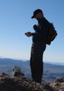
With 360-degree views that included more distant ranges like the Rincons, Catalinas, and Santa Ritas – in combination with the immediate views of the surrounding peaks, ridgelines, and canyons of the Sierritas – the summit views of Keystone were just awesome. There are several radio towers on the summit to explore as well. If you make your way to the highpoint point by the chain ‘railing’ [ photo ] , the summit register is located under a small rock pile at the base of a brown post [ photo ] . There are many signings from the late 1980’s. Interestingly enough, compared to other registers that go back to the 1980’s, the condition of this one was by far the best I’ve ever seen, and the signings from the 1980’s are in as good if not better condition than most summit logs that are just 2-3 years old.

After spending some quality time on the summit, I headed back down the main dirt road. For a change of scenery, I turned left on another jeep road, located a little under a mile from the summit. It’s slightly longer than staying on the main jeep road, [and regains some elevation], but the payoff is definitely worth it. Since it rides a ridge [instead of contouring like the main road], the views are much nicer. That said, just after reaching the highpoint on this ridge, I did have a brief bee scare, which fortunately proved to be benign. I reached the highpoint and had just started to descend when I heard LOTS of buzzing. I froze and looked up to see a swarm of bees about 20-30 feet down the jeep road flying across. It wasn’t the type of swarm where the bees look like a single huge solid object; they were more spread out with a few centimeters between each bee. Nonetheless, it was a poo mess TON of bees! Horrified and fascinated at the same time, I stood there frozen in place for a few seconds just watching them. Then I came to my senses and bolted back up the jeep road the other way. However, a few seconds later when I glanced over my shoulder, the bees were gone and the buzzing had stopped. I continued on way, going right by the section of road that the swarm had flown across not more than a minute or two earlier.

After reconnecting with the main jeep road, it wasn’t long before I passed by the abandoned cabin / camp area, which was really neat. There were also several mines in that area, many of which were visible right from the main jeep road. I was tempted to investigate but figured I’d enjoy it more when my equilibrium is back to normal, [and when there’s not a violent storm about ready to unleash on the area]… monsoon season started a few days ago in Southern AZ, and shortly after my hike, there was some fancy lightening right overhead. Luckily, I got back just in time to enjoy the show from the seat of my car.
 Culture
 Culture [ checklist ]
[ checklist ]  Arrastra  Benchmark
_____________________
God save the Prom Queen, cuz [reality check!] AEG's King...!
 
Apr 14 2013
avatar

 Guides 93
 Routes 397
 Photos 4,984
 Triplogs 4,124

49 male
 Joined Jun 20 2003
 Tucson, AZ
Keystone PeakTucson, AZ
Tucson, AZ
Hiking avatar Apr 14 2013
fricknaleyTriplogs 4,124
Hiking8.57 Miles 2,023 AEG
Hiking8.57 Miles   2 Hrs   53 Mns   3.36 mph
2,023 ft AEG      20 Mns Break5 LBS Pack
 
Linked   none no linked trail guides
Partners none no partners
finally made my way out to check out keystone peak early sunday morning. very windy. saw 4 deer. peaceful stroll up the dirt road. magnificent views up top
_____________________
hi
 
Apr 03 2013
avatar

 Routes 2
 Photos 1
 Triplogs 9

73 male
 Joined Apr 11 2013
 Tucson, AZ
Keystone PeakTucson, AZ
Tucson, AZ
Hiking avatar Apr 03 2013
desertdutchmanTriplogs 9
Hiking4.25 Miles 975 AEG
Hiking4.25 Miles   2 Hrs   7 Mns   2.01 mph
975 ft AEG
 no routesno photosets
1st trip
Linked   none no linked trail guides
Partners none no partners
_____________________
 
Jan 06 2013
avatar

 Guides 9
 Routes 33
 Photos 780
 Triplogs 4,634

44 male
 Joined Nov 25 2008
 Scottsdale, AZ
Keystone PeakTucson, AZ
Tucson, AZ
Hiking avatar Jan 06 2013
BoonemanTriplogs 4,634
Hiking9.00 Miles 1,975 AEG
Hiking9.00 Miles   2 Hrs   15 Mns   4.00 mph
1,975 ft AEG
 no routesno photosets
1st trip
Linked   none no linked trail guides
Partners none no partners
I went out for a solo hike in the Sierritas this morning to summit Keystone Peak. The hike itself isn't all that great since you're simply following a gravel road all the way to the peak. The view, on the other hand, might be one of the best in Southern Arizona!
_____________________
 
Dec 04 2012
avatar

 Guides 4
 Photos 542
 Triplogs 573

46 male
 Joined Oct 19 2010
 Mesa, AZ
Keystone PeakTucson, AZ
Tucson, AZ
Hiking avatar Dec 04 2012
Charger55Triplogs 573
Hiking8.40 Miles 1,465 AEG
Hiking8.40 Miles   4 Hrs   30 Mns   1.87 mph
1,465 ft AEG
 no routesno photosets
1st trip
Linked   none no linked trail guides
Partners none no partners
As far as dirt road hikes go I liked this one quite a bit. The first 1.3 miles are well-shaded. The next 1.3 miles contain many level stretches. The cabin is roughly at the halfway point. You can rest on the bench, the picnic table or on the old sofa inside the cabin. All that's in there is the sofa and a campaign sign that says "Ramon Valdez for County Commissioner". Man, those politicians are shameless. They'll put campaign signs anywhere!

While resting at the cabin a border patrol agent passed me in a pickup truck. I actually got a friendly wave out of him. I caught up with him at the first saddle that faces west. He was using his binoculars to scan the valley below. West of Keystone Peak and east of the Baboquivari Mountains lies the Altar Valley - a known trafficking corridor.

Speaking of Baboquivari, its peak comes into clear view for the remainder of the hike. It towers over the rest of the range the way the Empire State Building towers over the New York skyline. It' s very tempting to add it to my to-do list, but without climbing skills it' s better suited for my fantasy list. I'll put it right below Ixtaccihuatl and above the Appalachian Trail.

From the summit the views open up even more. You can see Picacho Peak, the Catalinas, downtown Tucson, the Rincons, Mount Wrightson and all the telescopes and observatories on Kitt Peak in great detail. The views are even better to the south, but I'm not familiar with those ranges. It's possible I was looking at ranges all the way on the other side of the border.

I descended at a leisurely pace. There are several benches along the route. I know hiking purists abhor benches, but I don't mind them. They offered a nice place to sit and enjoy the scenery.
_____________________
"I've driven across deserts, driven by the irony, that only being shackled to the road could ever I be free"
- Frank Turner "The Road"
 
Apr 06 2009
avatar

 Guides 6
 Routes 40
 Photos 887
 Triplogs 214

44 male
 Joined Dec 06 2003
 Bordeaux, France
Keystone PeakTucson, AZ
Tucson, AZ
Hiking avatar Apr 06 2009
Davis2001r6Triplogs 214
Hiking8.40 Miles 2,013 AEG
Hiking8.40 Miles   3 Hrs   30 Mns   2.40 mph
2,013 ft AEG
 
1st trip
Linked   none no linked trail guides
Partners none no partners
We wanted a little warm up hiking before climbing Babo and this was one of the choices. It's a nice little road walk, steep in places so it's still a workout. Nice views along the way. There is a nice little cabin about halfway up that would be a cool place to camp, had a BBQ and everything, probably need land owners permission though? We had a little fun on the mountain given that the peak is named Keystone, we split a 12 pack of Keystone Light for the hike :)

Saw a gardener snake on the way down and a bull as well. The moved the bull along for a 1/4 mile until there was an opening he could pull off the road. At that point he squared up to us so we backed off. Brian and I still walked along the side of the road, Scott went over the ridge ready to take pictures when he charged us. Didn't happen though.
_____________________
 
Apr 04 2009
avatar

 Guides 6
 Routes 13
 Photos 1,377
 Triplogs 184

41 male
 Joined Mar 29 2007
 Reno, NV
Keystone PeakTucson, AZ
Tucson, AZ
Hiking avatar Apr 04 2009
sbkelleyTriplogs 184
Hiking8.40 Miles 1,465 AEG
Hiking8.40 Miles   3 Hrs   30 Mns   2.40 mph
1,465 ft AEG
 no routesno photosets
1st trip
Linked   none no linked trail guides
Partners partners
aspen_oaks
Davis2001r6
The Keystone Lite did indeed punctuate a hilarious summit moment. Very off-the-beaten-path style hike up a good road. Nice panoramic views in all directions. I think the bull experience could have been funnier had Tim tried to pass it as he initially thought. No communication tower climbing - the view was pretty good and the wind was whipping. Great central viewpoint for southern AZ landmarks though. Babo beckoned for the next day
_____________________
  1 archive
Jun 22 2008
avatar

 Guides 28
 Routes 20
 Photos 672
 Triplogs 169

47 male
 Joined Jan 30 2008
 Old Pueblo
Keystone PeakTucson, AZ
Tucson, AZ
Hiking avatar Jun 22 2008
JeffshadowsTriplogs 169
Hiking8.40 Miles 1,465 AEG
Hiking8.40 Miles   2 Hrs   24 Mns   3.50 mph
1,465 ft AEG
 no routes
1st trip
Linked   none no linked trail guides
Partners none no partners
Keystone Peak is listed number 42 in terms of prominence in the state, so despite being a dirt road it's still a good hike. Lots and lots of wildlife back in there; deer galore, along with squirrels and lots of bird activity in the lower canyon. The trail is steep in spots giving one a chance to get a slight workout, but it certainly isn't difficult. The mining relics and pristine scrub oak forest alone make the hike worth the trip. The old McGee cabin is a really cool diversion, too.

When I was there I didn't encounter anyone other than the relative of the family that owns the property on his bike. He did mention that the trail can be popular with ATV-ers and mountain bikers, but there's no sign of the damage that usually becomes a trail accustomed to that type of use.

The views from the summit and the communication tower were awesome. I would have had a great view of Baboquivari and Kitt but there was much too much dust and haze in the air. The view of Wrightson and south into Mexico was still pretty nice, though...
 Culture
 Culture [ checklist ]
[ checklist ]  Mine Shaft  Spring Box
 Named place
 Named place [ checklist ]
[ checklist ]  Bills Spring
wildflower observationwildflower observationwildflower observationwildflower observationwildflower observation
Wildflowers Observation Isolated
_____________________
AD-AVGVSTA-PER-ANGVSTA
 
Mar 24 2008
avatar

 Triplogs 129

64 male
 Joined Dec 17 2004
 Gilbert, AZ
Keystone PeakTucson, AZ
Tucson, AZ
Hiking avatar Mar 24 2008
azpeavyTriplogs 129
Hiking8.00 Miles 1,483 AEG
Hiking8.00 Miles   2 Hrs   35 Mns   3.10 mph
1,483 ft AEG
 no routesno photosets
1st trip
Linked   none no linked trail guides
Partners none no partners
Keystone Peak (6188 ft) is the highpoint of the Sierrita Mtns which are located about 13 miles west of the town of Green Valley. Access is from the east via McGee Rd. At the end of McGee Rd is a large water tank and gate.

Park near the water tank and follow a dirt road to the summit. The summit is dotted with various communication towers. Great views exist of Baboquivari and Kitt Peak to the west and Mt. Wrightson to the southwest. Sites along the road include a family cemetary (most likely private property), an early 1900's cabin and a few mines.
_____________________
 
average hiking speed 2.45 mph

WARNING! Hiking and outdoor related sports can be dangerous. Be responsible and prepare for the trip. Study the area you are entering and plan accordingly. Dress for the current and unexpected weather changes. Take plenty of water. Never go alone. Make an itinerary with your plan(s), route(s), destination(s) and expected return time. Give your itinerary to trusted family and/or friends.

helpcommentissue

end of page marker