username
X
password
register
for free!
help
ArticlesGuidesRoutes
 
Photosets
 
 Comments
triplogs   photosets   labels comments more
Cline Creek Ruins - 14 members in 26 triplogs have rated this an average 3.2 ( 1 to 5 best )
1, 2  Next
26 triplogs
login for filter options
Mar 13 2024
avatar

 Routes 7
 Photos 240
 Triplogs 19

male
 Joined Nov 24 2023
 Tempe, AZ
Cline Creek RuinsPhoenix, AZ
Phoenix, AZ
Run/Jog avatar Mar 13 2024
overthehillsfarawaTriplogs 19
Run/Jog11.73 Miles 2,129 AEG
Run/Jog11.73 Miles   4 Hrs   54 Mns   2.39 mph
2,129 ft AEG10 LBS Pack
 
1st trip
Linked   none no linked trail guides
Partners none no partners
Parked at one of the 2 dirt spaces at the end of 12th street, easily reachable by any vehicle. Planned to do a CCW loop, aiming to arrive at the east ruins for sunrise first. Included the route since this one is well documented enough already. Followed a primitive road for 3 or 4 miles east to the southeast base of the crescent shaped mountain. Here there was a well trodden and clear path heading up to the mountain, and it was easy to follow most of the way. In spots where I lost it briefly, it was easy enough to tell the general direction to ascend, eventually getting funneled into a chute that was the steepest part and reminded me of doing Camelback. A couple small false summits appear with the objective visible out on the ridge. The ruins were nice, well defined low walls all around, and in back a higher section of wall around 6 feet tall. There were a few pieces of pottery gathered in 1 spot but they didn't look very old to me, the color and shape, but what do I know, maybe someone else can chime in. Took a lot of time exploring and taking pictures.
Coming back down I finally took on an infamous cholla ball which had to be dislodged with a hair comb. Got some smaller needles that required stripping off past the sock and tweezing out. Highly recommend a comb and tweezers. At another point, felt my big toe getting scraped and took off my shoe and sock but couldn't find anything. Then discovered 2 giant cactus needles that had pierced through the sole of my shoe from underneath.
Reaching the base, I added a quick and easy diversion to the small hill just to the south. There was a nice petroglyph field there with lots of them scattered around
To complete the loop required going off trail for about a mile on the northeast section. This was the worst part. Very thorny brush and cacti everywhere. Also high grass made me nervous, I wouldn't personally want to try it in any warmer weather than it already was. Circling around eventually picked up a large open wash that I followed for about another mile or two on the north side, here I found a bone that looked like maybe the base of a spine. Then I found lots of trash, bottles, plastic caps, straws, blown up golf balls in the wash on the north, took what I could and packed it out.
Picked up the primitive road again and followed it to the west ruins. The road pretty much goes straight up to them. It's not a lot of elevation gain but it's VERY steep, quite a leg workout. Zigzagging will help. The west ruins were not quite as impressive as the east, which I expected, but I was still quite happy with them. Particularly one wall with a divider that remained in a "T" shape.
 
Dec 30 2023
avatar

 Routes 386
 Photos 49
 Triplogs 792

43 female
 Joined Jun 23 2015
 Phoenix, AZ
Cline Creek RuinsPhoenix, AZ
Phoenix, AZ
Hiking avatar Dec 30 2023
emilystardustTriplogs 792
Hiking10.34 Miles 1,938 AEG
Hiking10.34 Miles   7 Hrs   6 Mns   1.73 mph
1,938 ft AEG   1 Hour   8 Mns Break
 no routesno photosets
1st trip
Linked   none no linked trail guides
Partners none no partners
Warm day, but clouds helped a little. Cholla field near the second set was somewhat challenging to navigate. Everyone got a little something in their shoe/leg/lower extremity at some point. People shooting right near the turnoff into the path up was a little rough, but they left by the time we came back down.
_____________________
 
Apr 15 2023
avatar

 Guides 2
 Routes 207
 Photos 93
 Triplogs 204

male
 Joined Aug 08 2020
 Phx az
Cline Creek RuinsPhoenix, AZ
Phoenix, AZ
Hiking avatar Apr 15 2023
ScaredyCatTriplogs 204
Hiking11.70 Miles 1,709 AEG
Hiking11.70 Miles   6 Hrs   52 Mns   1.91 mph
1,709 ft AEG      44 Mns Break
 
no photosets
1st trip
Linked   none no linked trail guides
Partners none no partners
Route Scout Route Recorded  on Route Scout | Pop | Map | Popup | MapDEX
Worked late nt b4 so no early start. Going out night of so need to end early. Too hot in PHX but can't drive far. Looks like I found an outing that fits the bill, or so it seemed.

Parking for 2 vehicles, no cell signal and no other hikers. Solid start. Was ahead of schedule so checked out some side trails. One of which goes to the creek but didn't have time to follow it all the way.

Finally realized I had to hike through a wash to replicate the track. The suggested spot to climb out is easy to miss. The faint trail turns to no trail and terrain gets more challenging.

Got a 🌵 piece in my hand and went the wrong way to get away from bees. Very painful to pull out. Enough of this, I'll cut back toward where I came from. As the wash turned to scrambling, I ran out of water.

From this higher perspective, I spotted a road near where I turned around but unsure where it goes. Guess I'll throw all my marbles into this mystery basket. Went back down and tried following. Whew, it got me out.
 
Jan 06 2023
avatar

 Guides 41
 Routes 1,626
 Photos 14,983
 Triplogs 2,760

69 male
 Joined Jan 20 2009
 Far NE Phoenix,
Cline Creek Ruins - East-West, AZ 
Cline Creek Ruins - East-West, AZ
 
Hiking avatar Jan 06 2023
The_EagleTriplogs 2,760
Hiking9.33 Miles 1,858 AEG
Hiking9.33 Miles   4 Hrs   32 Mns   2.19 mph
1,858 ft AEG      16 Mns Break10 LBS Pack
 
1st trip
Linked   linked  
Partners none no partners
Route Scout Route Recorded  on Route Scout | Pop | Map | Popup | MapDEX
Been meaning to check these out for awhile.

I parked at the end of 12 street and started the CCW FR/wash walk to get to the off trail climb. The climb up wasn't all that bad. It was easy to dodge the prickly stuff. The East Ruins were more impressive than I expected. The far west wall was close to 6' tall.
[ youtube video ]

From here I thought I'd attempt to ride the ridge line down. There is a well worn path for quite a distance. I headed west until I lost the path and then headed south down the peak. (Based on the post hike satellite view, I should have dropped to the North)
I can't recommend the path I took down. The standing cholla was easy enough to avoid, but the cholla balls on the ground were near impossible to avoid.

I made my way over to the west ruins with a bit of off trail and some FR's.

The path up to the west ruins was extremely easy to follow. Motorcycles have worn a path most of the way up. I did not expect much up here, but once again, this one was much more extensive than I'd expected. A couple of walls up top and to the south, but quite a few lower on the top to the north.
[ youtube video ]

The rest of the hike was FR's getting back to my vehicle. With a capable 4wd vehicle, the climb to these 2 peaks could be very short. Perfect weather, I didn't pass a single person all day.
 Culture
 Culture [ checklist ]
[ checklist ]  Geocache
 Named place
 Named place [ checklist ]
[ checklist ]  Cline Well  Quail Spring

water 1 out of 5water 2 out of 5water 3 out of 5water 4 out of 5 Cline Well 76-100% full 76-100% full
water report recorded in the field on our app Route Scout Full and overflowing

dry Quail Spring Dry Dry
water report recorded in the field on our app Route Scout All the pumping equipment is still here but the holding tank has been removed evidently it's dried up
_____________________
There is a very fine line between "hobby" and "mental illness."
Dave Barry 🦅
 
Apr 07 2022
avatar

 Routes 175
 Photos 2,335
 Triplogs 191

44 female
 Joined Jan 21 2019
 Pine, AZ
Cline Creek RuinsPhoenix, AZ
Phoenix, AZ
Hiking avatar Apr 07 2022
jillyonanadventureTriplogs 191
Hiking4.02 Miles 690 AEG
Hiking4.02 Miles   4 Hrs   38 Mns   1.26 mph
690 ft AEG   1 Hour   26 Mns Break
 
1st trip
Linked   none no linked trail guides
Partners none no partners
Route Scout Route Recorded  on Route Scout | Pop | Map | Popup | MapDEX
Decided to check out another one from the ruins seldom seen book since I enjoyed my last one so much. Spoiler alert: This one was definitely not as exciting as the last… :sweat:

I’ve finally been officially cleared for any type of hiking (my sprain is healed :D ) so I really just wanted to do a peak, knowing it would be tough given I’m out of shape from all the resting & light hiking. A ruin at the top was an incentive I could get on board with, so it looked like a decent choice.

Last hike I drove too far and made my hike too short, so this one I parked where the book & HAZ tells you to park. It was odd because you are hiking on an old road for the beginning of the trail. There were visible tire tracks on the road, but the topo did not show it being an official road at all… :? Anyway, you’re hiking this flat-ish bumpy road for a couple of miles until your ascent starts. Apparently they saved all of the AEG for the last section at the end…

Getting up to the peak was STEEP! The overall AEG for the hike is not bad at all, but it’s the grade of the steepness that was challenging for me, especially with it being 90 degrees today. I was very slow getting to the top, but what matters is that I didn’t quit. I saw a baby desert tortoise on the way up; I was faster than him!

The ruin site was not as impressive as others I’ve seen, but it was overall large and contained several different “rooms.” I particularly enjoyed the window built into in one of the rooms. They did have nice views for sure! There were also some pottery shards scattered around throughout the whole site. One wall was larger than the rest and had some petroglyphs on the rocks below. I did see other glyphs that more looked like scratches and I didn’t photograph them as I wasn’t sure if they were even original. The summit of the butte had a lot of biting flies so I didn’t get to stay & look around as long as I’d like, but I did enjoy a nice break up there.

I had both the loop and the out and back mapped out, and decided to opt for the latter. I felt like I’d seen enough and it was really hot out there with no clouds. In fact, on the return I felt pretty overheated and took a few breaks in the shade of random bushes to cool down. Definitely should have started a tad earlier but good lesson to help me remember that the heat is now on in AZ. It’s time for canyons versus peaks in the valley. Overall, glad I saw a new place but would not return.
_____________________
Restless between adventures...
 
Feb 06 2021
avatar

 Guides 25
 Routes 376
 Photos 5,897
 Triplogs 346

40 male
 Joined Mar 01 2018
 Chandler, AZ
Cline Creek Ruins Loop, AZ 
Cline Creek Ruins Loop, AZ
 
Hiking avatar Feb 06 2021
John10sTriplogs 346
Hiking10.71 Miles 2,029 AEG
Hiking10.71 Miles   8 Hrs   5 Mns   2.00 mph
2,029 ft AEG   2 Hrs   43 Mns Break
 
1st trip
Linked   linked  
Partners partners
TboneKathy
Route Scout Route Recorded  on Route Scout | Pop | Map | Popup | MapDEX
I'd read about Cline Creek Ruins a few weeks ago and was excited to check it out. My hiking partner visited Elephant Mountain last year and was interested in Cline Creek as well, since the ruins here were part of the same series of defensive Hokoham structures in the area. I mapped out at loop of ~10 miles that would take us to the west and east ruins.

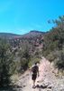
We parked at the small dirt pullout with space for two vehicles near the intersection of Jenny Lin Road and N 12th Street in New River. We decided to hike the loop clockwise and see the western ruins first. We started among a thick forest of cholla, and almost immediately we could see the cone-shaped mountain where the first set of ruins were located. It was easy, flat hiking along the forest roads early on, then a very steep approach as the road circled around to the north/northeast side of the mountain.

I was impressed with the quantity of ruins at the west site. From a distance, the peak was deceptively small, but there were numerous walls on top and a lot of foundations a little lower on the mountainside. The northern ridge below the peak had the remnants of multiple foundations, with doorways visible in the short walls, plus some pottery shards set out on a rock. The tallest walls were located along the east side of the peak, with a few more walls up on top and dozens and dozens of pottery shards set out on a large rock. Off the south side of the peak, far below, were more foundations that were pretty badly deteriorated, but it was clear that this was at one time a large complex with a lot of structures. The 360° views from the top were great--Pepsi Cap Mountain to the northwest, and to the east we had Black Mesa, Elephant Mountain, and the crescent-shaped ridge with the other set of ruins where we headed next. Before we started down, we checked out a panel of petroglyphs on the NE side of the mountain, just below the peak near the remnants of another wall.

We hiked east past Quail Spring and noticed a rock outcropping on a ridge that looked like it might be another ruin wall. I climbed up to check it out, but it didn't turn out to be anything interesting, though I did find a rock that appeared to be a metate as I headed back toward the trail. We circled around the north and east sides of the crescent-shaped ridge where the eastern ruins are located, and on the way up, we stopped at "Petroglyph Knob," a small hill covered with boulders with petroglyphs all over them. The dark rock provided a nice contrast for the rock art, and these were some of the most well-defined petroglyphs I've come across. There were also some less common figures--intricate maze/swirl patterns, lizards or toads, and one drawing that looked like a scorpion. We'd read there were ruins just north of that spot but didn't find anything.

From there, we made the steep climb north up to the ridge with the ruins. There was a faint trail where the brush was a little less dense, but we found ourselves in another cholla forest when we reached the first plateau on the climb up, and we had to stop a few times to pull cholla off our boots/socks. We could see the fortress on the peak at that point and followed the curve of the ridge until we reached it.

The fortress was pretty well intact--a thick rock wall ~3-5 feet tall circled the entire peak, and there was a circular room with shorter walls and a doorway inside the perimeter. In several places, we could see windows built into the walls that provided inhabitants with a protected view of the surroundings. Like the other site, we had great views from the top and enjoyed exploring the peak, and it was a relaxing spot for lunch. [ youtube video ]

Before starting down, we considered attempting to climb down the steeper western side of the ridge--we'd read there was another petroglyph site, but we decided to return the way we came up and circle around toward Cline Well, where we'd read there were more ruins and pottery shards. There was a lot of dirt bike/four-wheeler traffic around Cline Well, so we didn't spend much time there. We saw some rocks that might have been deteriorated foundations of old structures, but we didn't find anything definitive...just a few pottery shards before we circled back to our starting point, completing a loop of ~10.5 miles. Overall, a very enjoyable hike with some interesting history--I'd passed that area many times driving north on I-17 without knowing anything about what was there.
 Flora
 Flora [ checklist ]
[ checklist ]  Saguaro
 Named place
 Named place [ checklist ]
[ checklist ]  Cline Well

dry Quail Spring Dry Dry
water report recorded in the field on our app Route Scout
  1 archive
Mar 22 2020
avatar

 Routes 7
 Photos 1,242
 Triplogs 61

57 female
 Joined Nov 21 2015
 Phoenix
Cline Creek RuinsPhoenix, AZ
Phoenix, AZ
Hiking avatar Mar 22 2020
PicklesTriplogs 61
Hiking4.80 Miles 865 AEG
Hiking4.80 Miles   2 Hrs   40 Mns   2.25 mph
865 ft AEG      32 Mns Break
 
1st trip
Linked   none no linked trail guides
Partners none no partners
Route Scout Route Recorded  on Route Scout | Pop | Map | Popup | MapDEX
I've wanted to get to these ruins for some time, they were cooler than I expected!
I opted out of a loop hike and went straight for the destination. Parked my little Kia at the gate, opened my Route Scout and made my way 2+ miles down the obliging dirt road. I was surprised to see the well worn path leading straight up to the summit. I was also surprised at how steep it was! I checked out the rooms below before I made my way to the summit, where I spent most of my time. I was determined to find some glyphs and I did! Only two, but that's ok!
Very cool spot!
_____________________
 
Jun 16 2018
avatar

 Guides 1
 Routes 5
 Photos 61
 Triplogs 86

53 male
 Joined Jan 26 2011
 Phoenix, AZ
Cline Creek RuinsPhoenix, AZ
Phoenix, AZ
Hiking avatar Jun 16 2018
capcycloneTriplogs 86
Hiking4.25 Miles 1,129 AEG
Hiking4.25 Miles
1,129 ft AEG
 no routesno photosets
1st trip
Linked   none no linked trail guides
Partners none no partners
Quick hike up to the ruins and back down for a quick morning hike. Nice weather for June!
_____________________
 
Apr 20 2018
avatar

 Photos 116
 Triplogs 18

male
 Joined Feb 13 2003
 Tempe, AZ
Cline Creek RuinsPhoenix, AZ
Phoenix, AZ
Hiking avatar Apr 20 2018
kenjacobsenTriplogs 18
Hiking8.50 Miles 1,129 AEG
Hiking8.50 Miles
1,129 ft AEG
 no routes
1st trip
Linked   none no linked trail guides
Partners none no partners
Here are some drone shots of the main Cline Creek area "fort", to add to all the previous photos and interesting comments.

I'm beginning to suspect that these super-thick walled forts, which appear sporadically over a huge area, were meant as refuges for the nearby settlements, which unlike the forts on the Agua Fria plateau, were unprotected by cliffs or thick walls. It's also clear that it's intended to communicate with the similar fort on Elephant Mountain to the east.

In fact, there's a line-of-sight connection between the big fort on the south end of Black Mesa, to this fort via the "Pepsi cap" fort and the "Alpha fort" just to the north. That meant a signal could go between Elephant mountain to the Black Mesa fort up on the Agua Fria plateau over 20 miles away almost immediately.

There's also a direct line of sight connection with the Dutch Mesa fort, about 15 miles to the east.

I can't personally find any connection to the east with the Elephant Mountain fort –anybody know of one?
_____________________
  8 archives
Apr 09 2017
avatar

 Routes 7
 Photos 273
 Triplogs 234

54 male
 Joined Jul 16 2011
 Phoenix, AZ
Cline Creek RuinsPhoenix, AZ
Phoenix, AZ
 Hiking avatar Apr 09 2017
EartheistTriplogs 234
 Hiking4.17 Miles 692 AEG
 Hiking4.17 Miles   2 Hrs   8 Mns   2.41 mph
692 ft AEG      24 Mns Break
 no routes
Linked   none no linked trail guides
Partners none no partners
wildflower observationwildflower observationwildflower observationwildflower observationwildflower observation
Wildflowers Observation Isolated
_____________________
 
Jan 06 2017
avatar

 Guides 1
 Routes 13
 Photos 444
 Triplogs 12

76 male
 Joined Nov 10 2014
 Peoria, AZ
Cline Creek Trek, AZ 
Cline Creek Trek, AZ
 
Hiking avatar Jan 06 2017
HikingBuddyTriplogs 12
Hiking6.75 Miles 561 AEG
Hiking6.75 Miles   3 Hrs   49 Mns   1.88 mph
561 ft AEG      13 Mns Break
 
1st trip
Linked   linked  
Partners none no partners
Decided to test out a new day/overnight backpack on a local trail and see some ruins -- kinda a "twofer" so I meandered along the Cline Creek Ruins route on a beautiful friday. Only spotted a few potsherds but warmed up to my new Osprey Stratos 36, more volume than I needed for a few hour hike but very comfortable. The service road that parallels some of cline creek is ok but not much fun so I hiked in the creek bed which was pretty good after recent rains. I'd like the area a lot so i'll hike trail again just to see ruins in the area.
_____________________
 
May 28 2016
avatar

 Photos 4
 Triplogs 1

55 male
 Joined May 28 2016
 scottsdale, az
Cline Creek RuinsPhoenix, AZ
Phoenix, AZ
Hiking avatar May 28 2016
jlaneTriplogs 1
Hiking8.50 Miles 1,129 AEG
Hiking8.50 Miles   3 Hrs   25 Mns   2.49 mph
1,129 ft AEG
 no routes
1st trip
Linked   none no linked trail guides
Partners none no partners
Solo hike, first time using RouteScout and for 4 miles in a row was startled by the bird calls until I finally turned down the media volume on my phone. Had never done a "gps" hike before, I mostly hike well signed trails in town, so this was interesting da. Lost the trail a few times by taking the wrong 4 wheel drive track and either backtracked or cut across the desert to link back up. Big thank you to whomever did the cairns on the north side of the loop. The trail was very overgrown in parts and I wouldn't have able to follow it without a little guidance. Gaiters and pants were a necessity. Saw some ruins and petrogylphs. Would love for someone to let me know which petrogylphs are authentic and which are more modern interpretations of rock art. Saw one guy 4 wheeling up the road and that was it for other humans. Found an antler shed and a horseshoe. Nice day of solitude and trying to follow the gps. Is there a way to get RS to make the way I am facing up on my cell phone screen as opposed to to the top of the screen always being north? Will try and post a few pictures.
wildflower observationwildflower observationwildflower observationwildflower observationwildflower observation
Wildflowers Observation Isolated
Some Saguaro blooms, some Chain Fruit Cholla blooms.
_____________________
  1 archive
May 07 2016
avatar

 Guides 1
 Routes 226
 Photos 1,675
 Triplogs 1,867

65 male
 Joined Oct 17 2008
 Phoenix, AZ
South of New River Mesa, AZ 
South of New River Mesa, AZ
 
Hiking avatar May 07 2016
rcorfmanTriplogs 1,867
Hiking8.94 Miles 2,070 AEG
Hiking8.94 Miles   5 Hrs   28 Mns   1.92 mph
2,070 ft AEG      48 Mns Break12 LBS Pack
 
no photosets
1st trip
Linked   linked  
Partners none no partners
The main goal for this hike was to be the first to find geocache, 4KEF. It was hidden in mid-march and so far, no one had made the effort to find it. It is hidden at the base of some cliffs off the south side of New River Mesa.

I started my hike at the Tonto NF entrance at the north end of 20th St. I walked down the road then went cross-country a short bit to another road I knew of, then continued along roads until I was about .6 miles from the cache. From there I skirted around a hill and dropped into a wash that would take me near it. Somewhere along the wash, a bee got stuck under my pack's left shoulder strap. It freaked, stung me, and before I knew it, I was under attack by a few bees. I ended up getting stung once more on my neck before I got away from them. Fortunately I'm not allergic to them, so it was just a big annoyance.

About .2 miles from the cache, I left the wash and continued along a steep scree filled slope. I reached the cache and signed in as the first finder. I was happy about that as this was a milestone for me, 100 consecutive months of being the first finder of at least one cache a month. :y:

My next objective was to find another geocache, In Memory of Sharon Severance. It was hidden on the ridge SE of the Cline Creek ruins earlier this year. So after leaving 4KEF, I dropped into the wash then followed it a ways past where I entered it earlier. Along the way, a rattlesnake buzzed at me. I had sort of zoned out and wasn't paying attention. I try to be wary and the rattle certainly reminded me to be so.

Eventually, I hung a left and exited the wash. Before heading up the mountain, I stopped for a few minutes for some drink and a bite to eat. Instead of heading up towards the ruins, I headed up to a point farther west to avoid the really steep stuff, then followed the ridge up to the ruins, an old fortress. This was my third time visiting the ruins and it's always been interesting to check them out.

I continued along the ridge to the cache and quickly found it and signed in. I also stopped and removed the prickly grass bits that had worked their way into my shoes and socks.

From there I continued along and down the ridge towards the petroglyph site. I was last there a bit over six years ago when I found another geocache, Treasure's All Around. There're petroglyphs of several different types of animals, including a scorpion. I don't recall seeing a scorpion petroglyph any other place.

After leaving the petroglyph site, I just followed the road back to where my truck was parked.
wildflower observationwildflower observationwildflower observationwildflower observationwildflower observation
Wildflowers Observation Isolated
Some Pickly Pear and Hedgehog cacti were blooming, along with some Saguaro and Palo Verde.
_____________________
Go find a LonelyCache
 
Mar 14 2016
avatar

 Photos 94
 Triplogs 14

44 male
 Joined Feb 05 2016
 Anthem, AZ
Cline Creek RuinsPhoenix, AZ
Phoenix, AZ
 Hiking avatar Mar 14 2016
phlakTriplogs 14
 Hiking8.50 Miles 1,129 AEG
 Hiking8.50 Miles   4 Hrs   15 Mns   2.00 mph
1,129 ft AEG
 no routesno photosets
1st trip
Linked   none no linked trail guides
Partners none no partners
I live up here and I do this hike often with the pup. I actually found it on a site online like others with very little to work with but ended up comparing a topography map he used to google maps and found 4 of his ruin sites. Since then I have scoured the are finding around 12 more very nice ruin/petro sights. I really enjoy the more remote harder to reach ones to the north. Just wanted to mark that I did this hike for my log book on here. I am not going to go into detail of the hike as everyone else has done a great job describing this hike.
_____________________
 
Feb 22 2016
avatar

 Guides 9
 Routes 473
 Photos 8,433
 Triplogs 626

79 male
 Joined Dec 07 2010
 Phoenix, AZ
Cline Creek Meander, AZ 
Cline Creek Meander, AZ
 
Hiking avatar Feb 22 2016
Oregon_HikerTriplogs 626
Hiking6.90 Miles 1,147 AEG
Hiking6.90 Miles   6 Hrs   32 Mns   1.14 mph
1,147 ft AEG      30 Mns Break12 LBS Pack
 
Linked   linked  
Partners none no partners
I returned to the Cline Creek area in the southwest corner of the Tonto Nat. Forest to search for more Indian ruins. This time I drove about 2 miles in on the 4x4 road that enters the Nat. Forest from the north end of 20th St to cut some distance off my hike. This is definitely a high clearance 4x4 road requiring some pin striping vs tire damage/clearance decisions. Along the drive in I stopped to check out a possible ruin beside the road and a couple points of curiosity (POC) I had observed on Google Earth. At the first stop about 0.3 miles from the end of 20th St. the rock piles I had seen in the bushes along the road did not appear to be ruins upon closer inspection. However I did find a brand new jogging stroller stashed in the bushes. That explained the strange tricycle type tire tracks I had seen in the road earlier. About 20 minutes later I encountered the owners, a young couple out for a walk with their baby. This was at the site of a long rock wall which appears to be related to historic ranching activity since there are the remains of a corral and a well nearby. I suspect the rock wall may have been built from a re-purposed pueblo style Indian ruin. This suspicion is based on the ruins and pot sherds I had found across the road from this location on my previous trip. Another POC seen on GE was what had appeared to be a foundation, perhaps for a ranch house. But it turned out to be a deep rectangular pit with plastered walls. My first thought was swimming pool but it was more likely for storing water.

After driving approximately 2 miles up the road in a generally east-north-east direction from the end of N 20th St, I parked and started my off trail hike. The first destination was a small hilltop (knob) on the east side of the road, almost a twin of the knob on the west side which has a nice collection of petroglyphs. There was no sign of ancient habitation on this hilltop, just a cairn. But it did give me a good view of a route up a ridgeline that extended east rising up to the crest of the hilltops along the west side of Cave Creek Canyon not far from the intersection of the Rhondo Spring and Black Mesa trails. The remainder of my hike was devoted to hiking up this ridgeline looking for signs of ancient habitation and then crossing over to another ridgeline which more or less paralleled this one to return to my starting point. I was beginning to give up hope of finding any ruins after hiking 2.4 miles from my vehicle when I discover the first ruin - a one room 8 x 10 foot rectangular room (pile of rocks) with lots of pottery sherds scattered nearby to confirm the ruin's origins. I followed the ridge all the way up to where it broadened out into a small plateau at the base of a steep hillside studded with layers of limestone cliffs. On this small plateau I found a cluster of ruins along with lots of pottery suggesting that there may have been a small pueblo style village here at one time. Turning around and starting the trek back I crossed over a saddle to the next ridge to the east and followed it back down. This ridge forms the north side of what I will call the south fork of Cline Creek Canyon (couldn't find a name on the maps) which extends up to Rhondo Spring. Along this ridge I found 3 more ruin sites bringing my total for the day to 8. My last stop was to check out a 33 ft diameter circle in a clearing that I had seen on Google Earth. It turned out to be a circle of rocks with a more rocks in the center forming a cross. Two small grave like mounds of rocks nearby indicated this may be someone's pet cemetery. It was a productive day of exploration while enjoying the beautiful spring greenery and wildflowers of the desert hills.
wildflower observationwildflower observationwildflower observationwildflower observationwildflower observation
Wildflowers Observation Light
Numerous clumps of Brittle Bush flowers, a few bushes with small orange flowers, and 3 to 4 Mexican Poppies.
_____________________
  3 archives
Feb 20 2016
avatar

 Guides 9
 Routes 473
 Photos 8,433
 Triplogs 626

79 male
 Joined Dec 07 2010
 Phoenix, AZ
Cline Creek RuinsPhoenix, AZ
Phoenix, AZ
Hiking avatar Feb 20 2016
Oregon_HikerTriplogs 626
Hiking5.50 Miles 1,143 AEG
Hiking5.50 Miles   5 Hrs   43 Mns   1.30 mph
1,143 ft AEG   1 Hour   30 Mns Break12 LBS Pack
 
Linked   none no linked trail guides
Partners none no partners
Wanted to hike somewhere new but didn't want to drive a long way so decided to check out the Cline Creek Ruins in the southwest corner of the Tonto National Forest near New River. There are two fairly well known hilltop Indian ruins in this area and I've seen both referred to as the Cline Creek Ruins. I'd been to the west ruins so this time it would be the east ruins. The east ruins are visible on Google Earth. I chose to start the hike at the north end of 20th St. The more common entrance is at the north end of 12th street where FR53 starts. The N 20th St entrance reduces the length of the hike by about 2 miles and appears to be popular with off-road enthusiasts. There is quite a network of ATV and 4x4 roads in this area, none of which are identified with forest road markers except for FR53. A quick look at the Tonto Nat. Forest website indicates they have not yet released a Motor Vehicle Use Map so use of these "roads" does not appear to be regulated yet.

The hike started out following a well used 4x4 track which could have accommodated my FJ Cruiser with minimal AZ pin striping. About a half mile up the road I encountered a large pickup truck parked by the side of the road with a guy dressed in camouflage enjoying a late morning beer sitting on the shady side of his truck. A few minutes of conversation revealed that he had been hunting javalina (rifle season) all morning and was taking a break. After discussing the peculiarities of these elusive beasts and my destination, I started to depart but first spotted a pottery sherd laying on the ground nearby. Deciding to check out the area for ruins on my way back, I continued up the road. After an easy approximately 2 mile hike on 4x4 road I started off trail more or less following the 1/20/2013 track posted by HAZer, azwildguide. The off trail hike is steep in some areas but fairly easy as off-trail ruin hikes go. Wildflowers were starting to show on this south facing hillside, mostly the brittle bush yellow flowers, adding to the beauty of this desert scenery. The cholla were annoying. The buds had dropped and were hiding in tall grass so I had to keep stopping to pull the spines out of my boots. Unfortunately my light weight desert hiking boots were not much protection for the more formidable spines on the buds dropped by the stag horn cholla so the encounter was somewhat painful.

I passed three other hikers coming back down on my way to the top - the only other hikers I would see all day. We briefly talked about the origins of the ruins. One of them thought the ruins might have been built by the army as a fortified observation post during the Apache war because he could find no pottery sherds at the site. After seeing the ruins, I highly doubt the validity of his speculation because these ruins have the typical layout and construction of other hilltop fortress type Indian ruins. One example is the fortress ruin at Elephant Mountain which is within sight of this ruin. The ruins were fairly impressive with some sections of the defensive wall still standing 5-6 feet high. The perimeter defensive wall enclosed an area approximately 130 feet long and 30 ft to 40 ft wide. (measurements made on Google Earth). The only interior structure was a circular wall at the east end roughly 20 ft in diameter. From GE it appears to be more rectangular with rounded corners.

I dawdled at the fortress site for almost 1.5 hours enjoying the pleasant spring temperatures and spectacular views while eating lunch and then snooping around for pottery sherds (none found). On the way back I took a slightly different route and came across the site of a small pueblo style ruin. The outlines of the walls were barely visible and some had probably been destroyed where the ground had been cleared of all rocks for a circular vehicle turn around at the end of a 4x4 track. The ruin was in a saddle at the base of a small hill (knob). On top of the knob I found a bunch of boulders with petroglyphs. These are obviously well known because there is a trail leading to the top. It was a nice collection of glyphs on 10 boulders.

Along the road on the way back I encountered two guys enjoying beer and the views while sitting on the shady side of their large 4-passenger ATV. They were perfectly content sitting there and seemed to be surprised that I was out hiking in this hot sun (couldn't have been more than 80 deg). When I told them in response to their query that I had just hiked to the top of that nearby peak, the more fit looking of the two exclaimed "I don't hike!!" The other one said they were enjoying a break from the chaos of their children and grandchildren. Now that I can understand. Further down the road I made a quick search for Indian ruins where I had found the pottery sherds earlier in the day. Sure enough, there was the rock outline of 3 to 4 rooms hidden in brush at the base of some fairly large trees along with a lot of sherds. It was a surprising find since it was in an area that would have been ravaged by floods over the many years since they were built. But the builders had used large rocks, enough of which remained to show the outlines of the walls. This Cline Creek area must have been a real hive of Indian activity 700-800 years ago. Unfortunately I also found a more recent artifact, an empty beer bottle which had been left by the javalina hunter I had encountered that morning. I don't understand, you've got a cooler sitting right there under your left elbow, why not just throw the empty into it? Oh well, other than this one minor negative it had been a great day.
_____________________
  1 archive
Jan 18 2016
avatar

 Routes 297
 Photos 6,928
 Triplogs 552

49 male
 Joined Dec 30 2007
 Avondale,Az
Cline Creek RuinsPhoenix, AZ
Phoenix, AZ
Hiking avatar Jan 18 2016
StoicTriplogs 552
Hiking5.65 Miles 825 AEG
Hiking5.65 Miles   4 Hrs   25 Mns   2.34 mph
825 ft AEG   2 Hrs    Break
 no routesno photosets
1st trip
Linked   none no linked trail guides
Partners none no partners
I took the pups up to the ruins. We spend about 30 minutes walking around at the top. On the way down, I decided to take a different route than planned. I went West around to Shoemaker Springs. We spent an hour at the spring talking to two people on horse back. On my way back to the truck, I stopped and talked to another hiker. Overall a great day out in the desert.
_____________________
 
Nov 29 2015
avatar

 Guides 2
 Routes 174
 Photos 1,554
 Triplogs 179

47 male
 Joined Jul 01 2011
 Wexford, PA
Cline Creek RuinsPhoenix, AZ
Phoenix, AZ
Hiking avatar Nov 29 2015
UberdroogTriplogs 179
Hiking6.97 Miles 1,449 AEG
Hiking6.97 Miles   3 Hrs   38 Mns   2.35 mph
1,449 ft AEG      40 Mns Break
 
Linked   none no linked trail guides
Partners partners
The_Dude
Another trip out. Did not make the great room. Coming from the saddle is not the way for me.
_____________________
 
Nov 29 2015
avatar

 Guides 1
 Routes 136
 Photos 1,367
 Triplogs 364

47 male
 Joined Jun 10 2011
 Phoenix, AZ
Cline Creek RuinsPhoenix, AZ
Phoenix, AZ
Hiking avatar Nov 29 2015
The_DudeTriplogs 364
Hiking6.63 Miles 1,348 AEG
Hiking6.63 Miles   3 Hrs   35 Mns   2.43 mph
1,348 ft AEG      51 Mns Break12 LBS Pack
 
1st trip
Linked   none no linked trail guides
Partners partners
Uberdroog
Nice Sunday morning hike that started out mighty cold, but warmed up quickly. We got up to the trailhead about 7 a.m. for the start, we parked just outside the gate and walked the jeep road up to the ruins. There are very substantial remains at the peak, remnants of at least 7-8 rooms, and a few good sized walls too. Many pottery bits around to find if you are keen for looking, there is also a collection already from previous visitors. We took a nice little break at the top, and then angled for the mountain just to the east with hopes of seeing the other ruins. We decided to take an approach from the north side, and bushwhacked up to the saddle from there. Going would have been cross-cutting a 60-70 degree scree slope from here, so we decided to just take a snack break and work our way back down. Good effort for some more nice views if nothing else. Surprisingly little wildlife to be seen out there, one rabbit and a few birds but otherwise quiet. The desert is very green out here, even some of the Goldeneye are blooming nicely.
_____________________
  2 archives
May 09 2015
avatar

 Guides 4
 Routes 205
 Photos 9,282
 Triplogs 526

72 male
 Joined Apr 06 2005
 Phoenix, AZ
New River Wander with Cline Creek Ruins, AZ 
New River Wander with Cline Creek Ruins, AZ
 
Hiking avatar May 09 2015
HansenazTriplogs 526
Hiking8.98 Miles 2,450 AEG
Hiking8.98 Miles   7 Hrs   1 Min   1.48 mph
2,450 ft AEG      56 Mns Break
 
1st trip
Linked   linked  
Partners none no partners
I've been having fun lately walking around the desert between the town of New River and the mesa of New River. There are a number of known ruins on the hilltops west of the New River Mesa which means the many high points in between are also good places to look.

I plotted a route today which would take me to a few new ones and up to a high shelf before looping back over a butte I know to have a nice ruin. This Cline Creek Ruin is a little confusing (to me) because a similar nice ruin on the mountain to the east is also called Cline Creek Ruin by some. I'm not sure about the name designations, but I planned to hit the butte-version, not the mountain-version.

Turned out to be another good loop. By now I'm a little surprised this area isn't more popular with hikers as it is nice country and easy to get to. There aren't trail heads and trails per se but there are plenty of jeep roads, many disused but plenty good for walking. The area does get some traffic by ATVs, shooters, and hunters.

As usual in the area I found a lot of pottery along the way and a few areas that were clearly habitation sites. When I got up to the shelf not far below the mesa edge I briefly considered continuing on to the mesa then to Black Mesa and out Spur Cross. That would be a nice one way trip. But I kept with the plan.

While looking around a habitation site just below the shelf I was startled by some very nearby javelina barks. They didn't show themselves but I kept a distance. I checked out a rectangular bare spot visible in the satellite view - nothing much there but a concentration of pottery so probably not natural.

I continued to find vaguely interesting things as I headed toward the Cline Creek Butte and finally a few petroglyphs.

The ruins on the butte top are impressive indeed, mainly because it has many rooms on many levels covering a big area. Detracting from the experience is the presence of some graffiti and that fact that the ruin walls in many places have been re-stacked.

Looping back I continued to find pottery concentrations and even a few glyphs. Nice day, nice walking if you can avoid the nasty cholla.
_____________________
 
average hiking speed 1.97 mph
1, 2  Next

WARNING! Hiking and outdoor related sports can be dangerous. Be responsible and prepare for the trip. Study the area you are entering and plan accordingly. Dress for the current and unexpected weather changes. Take plenty of water. Never go alone. Make an itinerary with your plan(s), route(s), destination(s) and expected return time. Give your itinerary to trusted family and/or friends.

helpcommentissue

end of page marker