|
| | | |
| |
|
| Hiking | 1.56 Miles |
1,288 AEG |
| | Hiking | 1.56 Miles | | | |
| 1,288 ft AEG | | | | |
|
|
| |
| Linked |
|
none
[ show ]
| no linked trail guides |
| Partners |
|
none
[ show ]
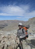
| no partners | | I arrived at the South Rim Backcountry office without a camping reservation, hoping to backpack the Hermit Trail. This was not to be. However, I did secure three nights at Cottonwood Creek off of Horseshoe Mesa. A bit disappointed since I'd hiked the Grandview Trail before, I started the descent into the Canyon still knowing I'd have a great several days of camping at this tranquil spot.
Heading down the trail, I passed some backpackers heading up a steep 'riprap' section. We stopped to chat, and I mentioned I'd be staying at Cottonwood for three nights. I saw one of the hiker's face light up. 'Oh,' he said, 'there's a trail heading down to the river off of the Tonto trail... the Old Grandview trail.' I was interested to hear this but apprehensive since I don't normally do off-trail hiking, and had never heard of this route. 'Heading west on the Tonto, you'll pass cliffs, then see something that looks like a rockslide. Totally unmaintained, unmarked trail, but it'll get you to the River,' he said. 'It's rough...' then he looked me over for a second, 'but you look like you could handle it.' Not sure if I was up for such a Canyon adventure, I thanked him for the information and moved on.
The next day I headed west on the Tonto trail intending to spend the day at Grapevine Creek, when I passed the precipitous cliffs mentioned by my unexpected guide. I saw a secondary cliff just ahead, below the Tonto formation. 'If there is an Old Grandview trail,' I thought, 'it would have to go down there.' As I approached this section, the Tonto trail turned away from the cliff edge, and a protrusion of the Tonto layer extended closer to the river. Always looking for photo opportunities, I decided to explore this area which offers great views of the Colorado River. A huge cairn marked the Tonto Trail right around here. 'Maybe it just marks this as a good location for photographs,' I thought, 'or maybe...'. I didn't see anything resembling a rockslide, so I wasn't convinced I'd found the Old Grandview trail. However, as I picked my way through the brush, I saw some smaller cairns. Curious, I followed these closer to the edge of the Tonto formation, and lo and behold, a hiking trail! I saw a somewhat well defined switchback adorned with yet another cairn. I knew I'd found Old Grandview. 'Maybe it's rough,' I thought, 'but if there's a trail there, I can hike it.' I grabbed my pack and headed off the Tonto for this adventure.
Reassured by how well defined the trail seemed, I was still a bit apprehensive given the sheer steepness of the cliffs in the area. I started down slowly, knowing I could turn around if things got too rough. The trail was actually relatively easy as I descended below the Tonto formation and made my way toward the saddle I'd seen earlier. And the views of the Colorado were incredible.
I carefully continued on the trail and made it up and over a ridge to the final descent to the river. The footing was not great the whole time; here it became worse and the trail much steeper. Still things were manageable and I came closer to my unexpected destination.
Finally, I arrived at a small sandy beach next to the peacefully flowing Colorado River. Feeling a sense of accomplishment, I put down my things and refreshed myself in the cold water. I hung out for a while, watching a rafting trip go by and getting some nice photos of the river in both directions.
The time came to head back, and the trip up from the river proved difficult. Gravity and the loose footing made climbing the trail difficult, and I'll admit I went to all fours at certain points to lower my center of gravity. I neared the top of this section, and some unexpected cloud cover seemed to be turning into a storm. I heard a rumble of thunder and looked back at the river. I could see the water rippling upstream toward me as strong winds headed my way. As I reached the top of this saddle, the winds hit and I simply leaned into a rock as very strong wind gusts pressed me into my temporary shelter. I got a sense for the powerful forces that have shaped this incredible canyon over the millions of years.
Finally the winds and a few raindrops passed, and I headed over the saddle, back up to the Tonto formation. I looked upstream, and amazingly a rainbow started to form over the river, from the South Rim to the North. I pulled out my camera and tried capturing the moment. I took a seat and simply took in the scenery. The moving clouds, changing light on the 'Vishnu' rock cliffs, and sunny upper reaches of the canyon beyond struck me as a sublimely beautiful scene. I just marveled to think how I had ended up at this spot and how, 10 minutes in either direction, I would not have seen this rainbow which now faded from view.
I climbed out of the lower canyon and made it back to the Tonto Trail, happy with my journey and accomplishment. The Old Grandview was certainly a challenge, but in this case provided me with a reward worth that effort and many times over. |
| | |
|
|
|
 Route Editor