|
| | | |
| |
|
| Hiking | 3.85 Miles |
1,641 AEG |
| | Hiking | 3.85 Miles | 6 Hrs 12 Mns | | 1.78 mph |
| 1,641 ft AEG | 4 Hrs 2 Mns Break | | | |
|
|
| |
| Linked |
|
none
[ show ]
| no linked trail guides |
| Partners |
|
none
[ show ]
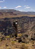
| no partners | | My research showed most hikers go up and down this peak from the east side. The available east side roads play a factor in this east route. Plus, it's an easier, shorter way to the top.
The survey parties did not use the east side at all. They initially started up from the south, then went up, what they called, a ridge from the west.
There's an excellent road to the south, however it goes through private land, and even after two calls to the BLM, no definitive info was given to me stating it was "OK" to use that road.
(A few years ago, Joe and the Eagle had to modify their track due to this "private land" issue).
Anyway, since surveyors placed the Sawyer Azimuth Mark near that west ridge, (and me, not wanting to use private land), I parked on the east side of the peak. I then hiked clockwise, around the base of the mountain, located the azimuth mark, and then hiked up from the west.
I completed my circle by going down the east side, back to my trailhead.
This circle track gave me a tour of most of the base of the mountain.
Excellent info on the Sawyer Benchmark datasheet helped me locate the azimuth mark disk.
Getting to the azimuth mark from the opposite side of the mountain had me using an old mine road for a bit, then crossing six or seven drainages.
Dodging cholla, and dancing on scree added some fun on the way.
The west ridge, up to the high point (and to the Sawyer benchmark) is actually nonexistent.
There's just some very high bumps, lined up in a row, going up to the peak, that I side-traversed to get up the mountain.
There's also a couple cliff bands to navigate on the way up the west side, plus cholla and more scree to add to my entertainment.
The actual peak is very narrow, and full of huge boulders.
Not too hospitable for navigating the top.
Going down the east side was initially steep, for about half the descent, then it got more gentle. The gentle part included the largest grove of prickly pear known to man.
I didn't bother the pears, and they didn't bother me.
All in all, a very nice hike. It's not that far away, so start early, and give Sawyer Pk its due. |
| _____________________
Not All Those Who Wander Are Lost
J.R.R.TOLKIEN |
| | |
|
|
|
 Route Editor


 but a remarkable year.