 Route Editor

| Guide | ♦ | 9 Triplogs | 1 Topic |
details | drive | permit | forecast | route |
stats |
photos | triplogs | topic | location |
| 182 | 9 | 1 |
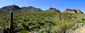
The Lonely Mountain by GrangerGuy  Overview OverviewSawyer Peak (4293’) is the highest point in the Black Mountains. It is the capstone of the 8300-Acre Tres Alamos Wilderness, which the BLM manages. There is no summit trail, but people seem to climb it both from the east and west. All routes are pretty steep, and the lower sections are infested with cholla, catclaw, and prickly pear. This is not a climb for the inexperienced or the faint-hearted. From the summit register logs, it looks like only one or two parties come here each year. The views from the top go forever, and the summit can be quite peaceful. History The wilderness was established in 1990 under the Arizona Desert Wilderness Act, driven largely by Arizona Representative Morris “Mo” Udall and Senators John McCain and Dennis DeConcini, and signed into law by President George H.W. Bush.[1]
The closest road to the wilderness boundary I could find comes in from the east. With a 4WD, you can get almost to the boundary. Driving directions are below. The entire area east of the wilderness is Arizona State Trust Land. An annual permit is required. It is labeled the “Tres Alamos Ranch.” The last gate on the drive is a barbed wire gate. I had trouble stretching the wire to close it. Henceforth, I will carry a rope and a stick to gain some leverage on these primitive gates. I parked at N 34.24155747 W 113.1630987. Hike I continued up the two-track from my parking spot until it ended at the wash, a short quarter-mile. From here, a faint single track points the way to the summit, but it quickly fades out. The route I took and reported by @FLYING_FLIVER and @joebartels as well (see the triplogs) stays on the broad rise between two drainages, always pointing toward the summit. The hike up the rise just follows the path of least resistance between the cholla, catclaw, and prickly pear. I avoided “most” of it. The route from parking to about 3500’ is pleasant enough. From 3500’ to the 4296’ summit, the way steepens significantly. Although I climb this elevation amount daily, this took twice as long, as it is a steep, scree-filled slope. Using my poles, I was able to climb pretty much standing up directly to the summit, with only a few times putting my hands onto the boulders. Thinking about the downclimb a couple of times, I considered turning back short of the summit but pressed on. There are a couple of rock outcrops in the ridge you climb. I found that passing close to them on the north side seemed to work well. The summit is really beautiful, with lots of nice boulders to sit on. The summit register is easily found. Not a lot of people come here. You are almost guaranteed solitude. There was a slight breeze as I ate my lunch at 9:30 am. I did annoy one rattlesnake at the summit. Never saw him. I contemplated other routes down but decided the devil I knew was most preferable and returned the way I came. Near the top, I pushed a rock down my route. I never heard it stop; the sound just faded away. My route down through the scree was just one short switchback after another. This kept me from gaining too much momentum like that rock. Altogether, two hours up, two hours down, and a glorious half-hour on the summit. Flora A few ocotillo, paintbrush, and hedgehog cactus blooming in early April. Fauna A couple of rattlesnakes along the trail warned me away. One deer as I was driving in. A number of mourning doves. References 1. http://www.azwild.org/whywild/1990-az-desert-wilderness-act-25th-anniversary.php Gate Policy: If a gate is closed upon arrival, leave it closed after you go through. If it is open, leave it open. Leaving a closed gate open may put cattle in danger. Closing an open gate may cut them off from water. Please be respectful, leave gates as found. The exception is signage on the gate directing you otherwise. Check out the Official Route and Triplogs. Leave No Trace and +Add a Triplog after your hike to support this local community. One-Way Notice This hike is listed as One-Way. When hiking several trails on a single "hike", log it with a generic name that describes the hike. Then link the trails traveled, check out the example. | ||||||||||||||||||||||||||||||||||||||||||||||||||||||||||||||||||||||||||||||||||||||||


