username
X
password
register
for free!
help
ArticlesGuidesRoutes
 
Photosets
 
 Comments
triplogs   photosets   labels comments more
Eagle Eye Mountains - 5 members in 10 triplogs have rated this an average 3.4 ( 1 to 5 best )
10 triplogs
login for filter options
Mar 30 2024
avatar

 Guides 59
 Routes 1,100
 Photos 1,191
 Triplogs 1,290

male
 Joined Jan 01 2023
 Arizona
Eagle Eye MountainsSouthwest, AZ
Southwest, AZ
Hiking avatar Mar 30 2024
pseudalpineTriplogs 1,290
Hiking3.49 Miles 1,358 AEG
Hiking3.49 Miles   2 Hrs   19 Mns   1.77 mph
1,358 ft AEG      21 Mns Break
 no routesno photosets
1st trip
Linked   none no linked trail guides
Partners none no partners
  1 archive
Mar 08 2023
avatar

 Guides 99
 Routes 1,487
 Photos 16,077
 Triplogs 1,377

male
 Joined Jan 07 2017
 Fountain Hills,
Sugarloaf Mountain - MaricopaSouthwest, AZ
Southwest, AZ
Hiking avatar Mar 08 2023
DixieFlyerTriplogs 1,377
Hiking9.78 Miles 1,677 AEG
Hiking9.78 Miles
1,677 ft AEG
 
1st trip
Linked   linked  
Partners partners
SecretMtnLover
Route Scout Route Recorded  on Route Scout | Pop | Map | Popup | MapDEX
Today I decided to go hike to Sugarloaf Mountain. This was probably the 4th or 5th peak named "Sugarloaf" that I have hiked in Arizona. This particular Sugarloaf (elevation of 3,418 feet and prominence of 1,188 feet) is in the Belmont Mountains in western Maricopa County. It is also the highpoint of the Hummingbird Springs Wilderness.

I parked at Dead Horse Tank and followed the excellent driving directions posted by @grangerguy. In fact, his triplog is a de facto guide for the hike!

The first half of the drive on Microwave Station Road had some rough places, but the second half of the Microwave Station portion of the drive was much better. The spur road going to Dead Horse Tank was in decent shape also. I was happy to have been driving a high clearance 4WD vehicle, but if the road was dry I would think that an AWD SUV with decent clearance, decent tires, and a competent driver could drive to Dead Horse Tank.

The hike was straightforward: follow a road for a couple of miles or so, then follow some cattle paths, go along a wash, make your way to a ridgeline, then head up to the summit. There was one short class 3 move not too far below the summit, but other than that the hike was all class 1. There were nice unobstructed 360 degree views at the summit.

On the drive in we saw 3 deer, and then we saw a wild burro along the hike in the morning.

This was an enjoyable hike, and was perhaps the easiest of the desert peaks that I have hiked this winter.

After the hike we stopped and hiked up to Eagle Eye Arch. Tracie the Intrepid had never been to this arch, but it was my second time in 3 days to do it. The climb up to the arch from the road is short and steep, gaining 400 feet in 1/4 mile. There is loose dirt and lava rock on the use trail, so it is a bit slippery. We did not go up to the peak this time.

Distance and elevation gain for the 2 hikes is below. Stats above are the sum of the two.
Sugarloaf: 8.24 miles with 1,177 feet of AEG
Eagle Eye Arch: 1.54 miles with 500 feet of AEG
 Flora
 Flora [ checklist ]
[ checklist ]  Wallrocket
 Fauna
 Fauna [ checklist ]
[ checklist ]  Wild Burro
 Culture
 Culture [ checklist ]
[ checklist ]  Summit Register Log
wildflower observationwildflower observationwildflower observationwildflower observationwildflower observation
Wildflowers Observation Moderate
Wildflowers were on the light side of moderate. There were sections with prolific poppies, and in one section there were lots of yellow flowers, which I believe were wallrockets.

water 1 out of 5water 2 out of 5water 3 out of 5water 4 out of 5 Dead Horse Tank 76-100% full 76-100% full
There was lots of water in the tank. You'd need a boat to get across it.
_____________________
Civilization is a nice place to visit but I wouldn't want to live there
  3 archives
Mar 06 2023
avatar

 Guides 99
 Routes 1,487
 Photos 16,077
 Triplogs 1,377

male
 Joined Jan 07 2017
 Fountain Hills,
Peak 4489 - Harquahala Mountains, AZ 
Peak 4489 - Harquahala Mountains, AZ
 
Hiking avatar Mar 06 2023
DixieFlyerTriplogs 1,377
Hiking7.60 Miles 2,760 AEG
Hiking7.60 Miles
2,760 ft AEG
 
1st trip
Linked   linked  
Partners none no partners
Route Scout Route Recorded  on Route Scout | Pop | Map | Popup | MapDEX
This was a hike to Peak 4489 (elevation of 4,489 feet and prominence of 1,689 feet), which is in the Harquahala Mountains. The trailhead for this peak is just off of Eagle Eye Road, so after the hike I hiked up to nearby Eagle Eye Peak.

Peak 4489
This was a fun little hike that was a bit tougher than I envisioned. I didn't have to drive too far off of pavement, and I think that a crossover SUV could have made it to where I parked. The road dropped into a wash just beyond where I parked, and the road was a bit rougher past that point. I could have driven it, but I was fine parking where I was.

I walked on the road for a half-mile, where the road ended at some archaeological ruins. There was a stone wall along with a couple of stone dwellings. I was not sure of the nature of the ruins, but on the way back from the hike a guy in an ATV was there and I stopped to talk to him for a few minutes. I asked him if he knew anything about the ruins, and he said that he had read that there was some sheep being raised there back in the day. He pointed me to another ruin site not far away that had another stone dwelling, a stone corral, and a water catchment tank; I went over and checked that out as well.

There was no trail on the hike, and once off the road I went cross country and climbed up a steep slope to a ridgeline, and then followed the ridgeline to the peak. The last part of the climb up to the ridgeline was very steep, but the footing was fairly solid, so it wasn't too bad. Once on the ridgeline I still had a fair amount of elevation to gain, but it was not as steep as the climb up to the ridgeline.

There was some vegetation to deal with, but it wasn't too bad. I'd describe it as a mix of open country and bushwhacking.

I saw a nice white-tailed deer buck on the way up, and we stared at each other for a few minutes. I also saw 3 cows not too far below the summit.

This was a nice hike, and the ruins made for a nice bonus.

Eagle Eye Peak
Eagle Eye Peak and Eagle Eye Arch were visible for most of the hike, so I figured that I would go hike up to them once I was finished hiking Peak 4489. I parked at the Eagle Eye Cemetery, and hiked from there.

I went on a road until I got below the arch, and made a steep hike up on a use trail. Along the way, I went right through another arch. Eagle Eye Arch was fairly large, and I was glad that I went up there.

It took me a while to get up to Eagle Eye Peak. I first started to go up there from near the arch, but after making a couple of class 3 climbs I got to a place that had more exposure than I was looking for, especially since I was there by myself. I wound up traversing around, and found and easy class 3 route up from south of the peak. The views were nice up there so I am glad that I made the effort to get up there.

I climbed back down the way that I came up, and made my way back to the trailhead.

Synopsis
This was a nice day in the Harquahalas. I was glad to hike to another P1K peak, and it was a bonus to see some ruins and a couple of nice arches.

Distance and elevation gain for the 2 hikes are below. Stats above are the sum of the 2.

Peak 4489: 5.59 miles with 2,103 feet of AEG
Eagle Eye Peak: 2.01 miles with 657 feet of AEG
 Geology
 Geology [ checklist ]
[ checklist ]  Natural Arch
 Culture
 Culture [ checklist ]
[ checklist ]  Corral  Stone Dwelling
wildflower observationwildflower observationwildflower observationwildflower observationwildflower observation
Wildflowers Observation Isolated
I hardly saw any flowers on Peak 4489, and there were just a few on Eagle Eye.
_____________________
Civilization is a nice place to visit but I wouldn't want to live there
 
Dec 16 2020
avatar

 Guides 4
 Routes 52
 Photos 1,303
 Triplogs 75

female
 Joined Feb 04 2017
 Sun City
Eagle Eye MountainsSouthwest, AZ
Southwest, AZ
Hiking avatar Dec 16 2020
caragrueyTriplogs 75
Hiking4.00 Miles 2,000 AEG
Hiking4.00 Miles
2,000 ft AEG
 no routes
1st trip
Linked   none no linked trail guides
Partners none no partners
Girls day hanging out..
_____________________
 
Mar 04 2013
avatar

 Guides 264
 Routes 2,798
 Photos 14,514
 Triplogs 5,895

55 male
 Joined Nov 20 1996
 
Eagle Eye Arch & Peak, AZ 
Eagle Eye Arch & Peak, AZ
 
Hiking avatar Mar 04 2013
joebartelsTriplogs 5,895
Hiking2.85 Miles 811 AEG
Hiking2.85 Miles   3 Hrs   27 Mns   1.25 mph
811 ft AEG   1 Hour   10 Mns Break12 LBS Pack
 
1st trip
Linked   linked  
Partners partners
outdoor_lover
The old west continues to intrigue. Pam said Preston was too big of a wuss to man up and conquer the peak so I had to step in.[1] This one starts wherever you please and Eagle Eye Cemetery works well. Shamefully trashed on the perimeter it boasts an intriguing twist. That being the attention to detail and creativeness in signage and fencing.

Eagle Eye "mountains" are the northeastern terminus of the Harquahala range. Everyone knows the song hark wha hala angles sing, glory to the bla bla bla... naturally I couldn't resist the adventure! It's difficult to explain. There is just something about the views from this range that intrigue. The contrast between peaks and flat expanse has a cinematic quality.

Upon reaching the arch the wind was borderline dangerous. Pam mentioned a route over the arch. I checked it out. It's almost rlrjamy (the artist currently riding the little bo peep moniker) type stuff. Getting up looks doable, getting down in gale force winds... not this cowboy.

Thus began the hunt for Red October. Riddle me this... Eagle Eye "Mountain" is black whereas Eagle Eye "Peak" is red. We searched and searched then found a route up directly to the peak. Difficult this was not. Rather enjoyable beyond anticipation.

1) exaggeration and falsification added for shock value
 Geology
 Geology [ checklist ]
[ checklist ]  Natural Arch
 Culture
 Culture [ checklist ]
[ checklist ]  Summit Register Log
 Named place
 Named place [ checklist ]
[ checklist ]  Eagle Eye Cemetery  Eagle Eye Peak
wildflower observationwildflower observationwildflower observationwildflower observationwildflower observation
Wildflowers Observation Isolated
Itty bitty and sparse for the most part. Down in the valley poppies dabbled on occasion.
_____________________
- joe
 
Mar 04 2013
avatar

 Guides 7
 Routes 73
 Photos 14,456
 Triplogs 628

62 female
 Joined Aug 19 2011
 Scottsdale, AZ
Eagle Eye Arch & Peak, AZ 
Eagle Eye Arch & Peak, AZ
 
Hiking avatar Mar 04 2013
outdoor_loverTriplogs 628
Hiking2.85 Miles 811 AEG
Hiking2.85 Miles   3 Hrs   27 Mns   1.25 mph
811 ft AEG   1 Hour   10 Mns Break12 LBS Pack
 
1st trip
Linked   linked  
Partners partners
joebartels
So, I knew I had to return to this area to bag the actual Peak. Preston and I had done the Arch a few weeks before, and I had found a possible way up to the Peak without having to go down and around, but it was sketchy. I knew Preston wouldn't be comfortable attempting it with his knees, so Joe became the natural choice. :) He's on the way out, and it's a short, sweet Hike. I knew he would find a Route if that one didn't work and it would be recorded on GPS. And he did... :y: Besides that, I know I've been frustrating him lately ](*,) and that he wanted to kick my :pk: so I figured I would give him the chance... :GB:

I played Tour Guide when we got there, showing him the Cemetery and the local Aguila dumping ground and then we head up to the Arch, finding the Trail easily. (Someone actually made an arrow with rocks, pointing to the Campground.) There was a breeze down in the Valley that continued to increase in intensity as we gained elevation. We got up in good time and the wind is now a 40+ MPH gale, threatening to blow us right through the Arch. :o I showed Joe the little chute to get up and around the end of the Arch, but having been up there before, I knew it was a borderline climb for me to get up on top. With the wind, there was no way I was going to attempt that one today. :stop: Joe "cowboyed up" and made it almost to the top, but decided that that horse was just going to be too wild of a ride today. :sweat:

Then the fun really began. Finding a Route up to the Peak without having to sacrifice the elevation we had already gained. It was only another 40 feet or so, up to the Peak, but we were faced with some pretty vertical smooth rock all along the base of the ridge. I showed him my option, but it still didn't look that great. Joe traversed further south to try to find an alternate, while I attempted it. Got to one position with about 7 feet left to go and just could not get past it... : rambo : So I climbed back down and went to find Joe who was having his own unsuccessful adventure. :sweat: We traversed further south and I attempted another spot and Joe went around to another. Within a minute or too, Joe appears above me, smiles, and disappears again. Once again, I ended up having to downclimb and then went around to find Joe's route. I can hear him and he's found a way all the way up and is now about 30 feet above me. : app : He guided me through the Route. The only disadvantage I found was that Joe has me in height and reach, so I found it to be a tad tougher than he did. I had to really stretch for those optimum handholds... :sweat: We make the top thinking that it's the Peak, but realize we've actually passed the "true" Peak and so we backtracked down into a saddle and back up.

Found a can in a can that may have been the original Peak Log, but if that was originally paper in there, it was already back to nature. There was also a baby food jar with a small notebook that had maybe a dozen names in it, with the most recent from 2010. Joe continued to traverse the Ridgeline to the north and made it out to the top of the Arch. He found some kind of symbolic shrine out there that was interesting. The wind was strong, but not quite as bad as it had been down at the Arch. He returned to the Peak and then the aerial show began. :DANCE: A pilot decided to buzz the Valley floor below us in his private plane and exit through the pass at the north end. He was only about 100 feet off the ground. Pretty cool. Then Nature decided to show us her aerodynamic wonders. The Cliff Swallows (fighter jets in disguise) decided to start dive bombing us. No way of getting a picture, those guys can maneuver on a dime. And then came the pair of Red Tailed Hawks. I think they're nesting in the area as Preston and I saw a pair when we were here the first time. We watched them ride the wind currents and I think Joe was even impressed. He may not be a "bird" guy, but he actually ended up snapping a few pics, so my attempt to "convert" him to the "wild side" was working.... :D

We finished traversing the Ridgeline to the south and headed down. We passed the "cave" that I had wanted to check out, but it turned out to just be a huge alcove that went in about 10 feet. I showed him the Crested Saguaro and we followed a pretty nice little Trail through the desert that intersected back up with the road.

We stopped in Wickenburg for a good lunch at El Ranchero and then headed back into town. It was a thoroughly enjoyable Hike with good company. Regained my confidence on some of my scrambling/climbing skills, which was sorely needed. : rambo : Thanks for joining me Joe! It was a good day! : app :

P.S. The JBM and PBM were non-existent today as long as we talked about the Hike and nothing else. Otherwise they were pegging out on other topics... :STP: I think we called it a "draw".... :gun: :wlift: :stretch: Either that, or he's a really good loser...:sl: :kf:
 Fauna
 Fauna [ checklist ]
[ checklist ]  Red-tailed Hawk
 Named place
 Named place [ checklist ]
[ checklist ]  Eagle Eye Ranch
wildflower observationwildflower observationwildflower observationwildflower observationwildflower observation
Wildflowers Observation Isolated
_____________________
Life is not a journey to the grave with the intention of arriving safely in a pretty & well preserved body, but rather to skid in broadside, totally worn out & proclaiming, "Wow What a Ride!"
 
Feb 18 2013
avatar

 Guides 117
 Routes 339
 Photos 11,415
 Triplogs 895

63 male
 Joined Dec 20 2010
 Sunnyslope, PHX
Eagle Eye MountainsSouthwest, AZ
Southwest, AZ
Hiking avatar Feb 18 2013
kingsnakeTriplogs 895
Hiking2.78 Miles 1,131 AEG
Hiking2.78 Miles   1 Hour   44 Mns   1.60 mph
1,131 ft AEG
 
Linked   none no linked trail guides
Partners partners
outdoor_lover
Second week in a row out here with Pam, this time to scale Eagle Eye Peak and it's house-sized arch. Turns out there is a foot path up. The path is steep and slippery. The path also passes through a tiny arch. There's more arches here than a McDonald's convention. There is some scrambling, and I was at the limit of my comfort zone. There's a short, but tricky, chute up the outside edge of the arch, but you would need to be braver than us to try to get to the outside top that way. Lots of exposure. Saw a couple, looked about our age, descending the wash between Eagle Eye Mountain and Cemetery Hill. We waved. I think they saw us. While in the arch, I noticed a goat path that travelled south, from the tiny arch, across Eagle Eye Peek's western slope. We took that, in the hope we would find an easy way to the massive cave a few hundred feet south of the Peek's summit. Definitely doable, but we decided to leave it for another day. We were eating lunch next to the central jeep trail, when I noticed the couple up in Eagle Eye Arch. Never saw them after that. Hope they did not fall off the backside. (The east slope is 400 feet straight down.) After lunch we went up the wash, an easy climb to the top of Cemetery Hill, which has quite a few flat shelves that would make awesome camp sites. Then we descended the north side of Cemetery Hill -- not bad except for attempted murder by a cat's claw -- back to Pam's SUV.
 Flora
 Flora [ checklist ]
[ checklist ]  Saguaro
 Geology
 Geology [ checklist ]
[ checklist ]  Natural Arch
_____________________
http://prestonm.com : Everyone's enjoyment of the outdoors is different and should be equally honored.
 
Feb 18 2013
avatar

 Guides 7
 Routes 73
 Photos 14,456
 Triplogs 628

62 female
 Joined Aug 19 2011
 Scottsdale, AZ
Eagle Eye MountainsSouthwest, AZ
Southwest, AZ
Hiking avatar Feb 18 2013
outdoor_loverTriplogs 628
Hiking2.78 Miles 1,131 AEG
Hiking2.78 Miles   1 Hour   44 Mns   1.60 mph
1,131 ft AEG
 
Linked   none no linked trail guides
Partners partners
kingsnake
Time to go up and see the big Arch! :D :y: I picked Preston up and away we went. Parked at the Cemetery and walked east up the dirt road that turns to the south and climbs up into the Valley. Once we topped out in the Valley, we encountered a nice flat area, east of the road, with a nice Fire Ring. :) The Arch was pretty much straight east of us here, and it looked like as good of a spot as any to head up. We Hiked up the gradual slope that was pretty much nothing but black and red lava rock. I kept a "straight on" course that was pretty open as far as vegetation goes, and soon it became apparent that this was a good route, as the open area I was following turned into a well defined Trail. :DANCE: This is no Game Trail folks, someone built this and it was pretty easy to follow, other than the fact that it was steep and loose in many spots. And it takes you right through another nice little Arch! :y:

Before we knew it, we were near the top. :D Just below, and to the right of the Arch, is the only spot where you have to do a serious little Scramble, to get up to the Arch itself. The Trail continues south just a little further and then ends. The Scramble part, up to the Arch, is a large Vase-shaped hole in the rock that you climb through and up. The Arch was very 8) and :pk: huge!!! The only drawback is there is alot of Graffiti up there... ](*,) Apparently, the way we came up, through that small scramble, is the only way up and down from this Arch, unless you are a climber. The other side of the Arch is straight down... :o There was a small Chute on the north side of the Arch and I took it, hoping that there was a way here to get up on top of the Arch, but once I topped out above the Chute and looked, there was just a tad too much exposure for me to want to continue... :stop:

We enjoyed the Arch for a bit, and then headed back down to the Trail. I followed the Trail further south up there, looking for access to get up to the Ridgeline, and found one possible spot, that's all...The rest was straight up climbing. One area looked doable, but it will involve good tread and not minding a little exposure, as it is smooth, domed, sandstone rock with little to no footholds or handholds. : rambo : Otherwise, the best route up to the Ridge is going to be back down the Trail through the smaller Arch. Another Trail that turns into a Game Trail, takes off to the South, about 50 feet below the small Arch, and traverses the slope through a couple of drainages. Then you'll have to do a Scramble back up to the Ridgeline. I will be returning to find a good Route up.

We gradually got back down to the Valley, following the Game Trail, where we laughed at a ninja Saguaro and took a small lunch break. After the break, we headed up to the Saddle between Eagle Eye Mountain and what Preston is calling Cemetery Hill to the north. Definitely a decent route from the Saddle up Cemetery Hill. Just go north towards a drainage and following the drainage up to the top. No Scrambling involved... :) There are some awesome Campsites up there. There are natural "Decks" up there with flat, grassy areas capable of allowing several tents... :) We found a decent route down the north side of Cemetery Hill, and got down in pretty short order and back to the Escape.

It was a good Hike! I love putting my Route finding skills to the test on stuff like this. Just need to go back now and hit the actual Peak and the large Cave on that Ridgeline. :D
Thanks for joining me Preston on another cool Eagle Eye Hike! : app :
 Fauna
 Fauna [ checklist ]
[ checklist ]  Rock Wren
 Geology
 Geology [ checklist ]
[ checklist ]  Natural Arch
 Named place
 Named place [ checklist ]
[ checklist ]  Eagle Eye Mountain
_____________________
Life is not a journey to the grave with the intention of arriving safely in a pretty & well preserved body, but rather to skid in broadside, totally worn out & proclaiming, "Wow What a Ride!"
 
Feb 13 2013
avatar

 Guides 7
 Routes 73
 Photos 14,456
 Triplogs 628

62 female
 Joined Aug 19 2011
 Scottsdale, AZ
Eagle Eye MountainsSouthwest, AZ
Southwest, AZ
Hiking avatar Feb 13 2013
outdoor_loverTriplogs 628
Hiking3.50 Miles 1,125 AEG
Hiking3.50 Miles   5 Hrs   36 Mns   1.74 mph
1,125 ft AEG   3 Hrs   35 Mns Break6 LBS Pack
 
Linked   none no linked trail guides
Partners partners
kingsnake
So, I'm driving around the Aguila area going to and from Alamo Lake and notice what is a possibly very large Arch just south of the Town of Aguila...I'm thinking, hmmm....Then Preston posts a Triplog of Alamo Lake and states that he is going to Aguila next week...Hmmm.... :sl: I PM him and it's on.... :DANCE:

Preston had the route all figured out already, so I just showed up at the local Cemetery and parked it...Preston poked around the Cemetery a little before I got there, so after getting situated, we took off. I'm not big on walking around in a Cemetery unless it has a lot of history, I just feel weird about that. But just outside of it, is the best place to park.

We had originally planned on a bigger Loop than what we actually did...We soon figured out that there is so much to explore in this little area that time was against us...Numerous Caves, Addits, Arches....Wow!!! There are two main Arches shown on the topo, but there are a bunch of little ones. The topo lists one of the smaller Mountains as Eagle Eye Mountain and the large Mountain as Eagle Eye Peak. Eagle Eye Peak has the large, main Arch. The other Arch on the topo is on a smaller hill behind Eagle Eye Mountain. We started the Loop going CCW, following a small dirt road, but decided against following the road the whole way, as it ends up too far west. Apparently, the local residents feel that this flat area around the Cemetery makes for a good dump as we ran into a couple of very large trashy areas, one on each side of the Cemetery boundaries...Pitiful... :sk:

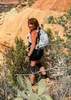
Preston's first goal was to hit a Cave shown on the topo. When I first saw it, I didn't think it was doable, but as we got closer, hmmmm, and up we went... :D What looked like a large Cave turned out to be more of an Alcove, with a smaller one right next to it. Nice views from here. Everywhere you looked in this little Range, there were Caves and Alcoves...You could spend days... :D And it also became very apparent, early on, that Birds of Prey love this area...Not only could you find a niche for selling bird poop, but apparently they dine up there as well, as there were small bird bones everywhere at the base of the cliffs. I even found a skull with the beak still attached... :o I also found a tiny legbone with a Band still attached. I took that one and am researching the Band.... :) We apparently were also bothering a pair of Hawks of some sort, as at one time they were soaring large circles around us, screaming their displeasure...Almost nesting time.... :) I'm thinking that they were possibly Swainsons...Could not get a picture, too far away and not quick enough, as I was usually clinging to a Rock at the time.... :sweat:

So after playing at the Cave/Alcove, it was time to get on top of Eagle Eye Mountain. Not happening from there, so we bushwacked pretty much at the base of the cliffs until we found a place to go up. It was steep and there was scrambling involved but all in all, not bad. Came upon another very cool Cave that was connected to another Cave above it. Could instantly tell that there would be no getting in the lower Cave without technical gear, but the higher one ended up being kind of accessible. It was not easy to get to the entrance and once there, you really could not go in more than 6 feet as the floor dropped away into the Cave below...Very sweet though...The longing for a rope was very strong here... :D

We topped out on Eagle Eye Mountain and were treated to some very sweet, clear views for miles in every direction...Spent some time enjoying this, taking pics and studying Eagle Eye Peak across the valley, including the incredibly disgusting Graffiti that someone took a lot of time and paint to do...Right at the big Arch too... ](*,)

We hiked along the very Rocky ridgeline and found an exit spot further south, as we wanted to get down to the Valley floor and continue south to the hill with the smaller Arch. Finding a Route is not easy, you can "cliff out" in alot of areas and all of it is pretty steep with ball bearing slopes and scree....But we lucked out and got down and proceeded over to the small hill. Decided to try to find a better route than what presented on the north side and we went over the ridge on the east end and came at it from the south. As we were climbing up the ridge, we saw a plane circling that looked "vintage"...I couldn't get a shot of it then, as it appeared to land at the Private Airport northeast of the Cemetery. I got a shot of it later, but it was out quite a bit and I had to use full zoom, so it's blurry.... ;)

Just before the last climb up to the Arch, I spotted a bunch of Bees flying in and out of the wall of the Cliff. We were slated to go right past that spot, but opted to drop down about 20 feet and go around. Apparently that was enough, as we were not bothered by dive bombing, stinging bees. It looked like they had a Hive in a crevice there.... :o Something for you all to keep in mind if you do this Hike...

The Arch was very cool, and although it was a small hill compared to the other "mountains" in this grouping, you still had some great views, including the entire little valley of this little Range... :)

After messing around up there a little bit, we opted to try to find a way down the north "face". I found it and it was actually pretty easy...:D Hardly any scrambling at all. We walked back through the Valley. There is actually a road that runs through the whole valley from the Cemetery out to Eagle Eye Road to the west. We followed this road until I spotted a Saguaro that looked like it was Crested. "Squirrel"! :sl: And it was a Crested! It's just a baby as far as Cresteds go, but it's on it's way... :y: After the photo ops were done, we intersected back up with the road and headed back to the vehicles.

Would have liked to Hiked up to the Peak and the big Arch, but time wasn't on our side today. Will be returning to this area very soon!!! What an awesome little area!!! I am actually working on a Description for this, as this area deserves to have it's own page... :) Perfect Hike for me at this time, since I'm really out of shape, but it was awesome...Thanks for the invite Preston!!! I'll be back... :D

Afterwards Preston and his wife Bernie treated me to some really good Mexican Food in Wickenburg called El Ranchero. It was really good and I would highly recommend the place... :) You picked all the winners today Preston...Thank you! Really good to see Bernie again too... : app :

I do apologize for the large Photoset...Very interesting area... ;)
 Fauna
 Fauna [ checklist ]
[ checklist ]  Kingsnake
 Geology
 Geology [ checklist ]
[ checklist ]  Natural Arch
 Culture
 Culture [ checklist ]
[ checklist ]  Aircraft
_____________________
Life is not a journey to the grave with the intention of arriving safely in a pretty & well preserved body, but rather to skid in broadside, totally worn out & proclaiming, "Wow What a Ride!"
 
Feb 13 2013
avatar

 Guides 117
 Routes 339
 Photos 11,415
 Triplogs 895

63 male
 Joined Dec 20 2010
 Sunnyslope, PHX
Eagle Eye MountainsSouthwest, AZ
Southwest, AZ
Hiking avatar Feb 13 2013
kingsnakeTriplogs 895
Hiking3.40 Miles 1,125 AEG
Hiking3.40 Miles   2 Hrs   1 Min   1.69 mph
1,125 ft AEG
 
Linked   none no linked trail guides
Partners none no partners
I like maps. Always have. I can remember being maybe six years old looking at my dad's camping topos, pretending I was moving troops. My favorite book was the West Point Atlas of Military History, which had those old-style slashes-for-hillsides topo maps for every battle in every war the US had been in from the French & Indian War through Korea. So, a few weeks ago, when I was looking at doing something near Alamo Lake, in satellite view, I noticed that there were these black splotches randomly around the western desert. Looked like lava cones, they were so dark compared to the surrounding terrain. I zoomed in on topo view for a splotch south of Aguila, and saw that there were two arches within a half mile of each other. At least according to the map, and as anybody who has been outdoors should know, maps lie. Happily, this time, they did not. :)

I planned out a route -- because planning is what I do, like most people breath :roll: -- but as any soldier knows, no plan survives contact with the enemy. So, at least as far as hiking goes, my plans are more guidelines to things I want to see, or routes that look like they might be good.

I don't visit many cemetery's, but it turned out there was some interesting graves, a few of which I straightened out as flags were drooping, or flowers had tipped over.

Pam and I then set out for Eagle Eye Mountain. She was a great pathfinder, finding routes up that I would have foregone for searching for an alternate, both on Eagle Eye Peak, and the mini-arch hill. As it was, for both, we took a different route down than up, giving future explorers two alternate approaches to each.

A couple of times we heard relatively sharp booms, which sounded like a large bore rifle, but then rather than hear a crack or zip nearby, we instead heard a boom overhead, going away, in a specific direction. Did not see any military jets, so not sonic booms. Also not explosive, as the sound was directional, rather than general. (Did hear some very deep, barely audible, rumblings that were probably explosive.) Saw 9mm luger, 9mm parabellum, .30-06, .30 (!?), .40 S&W, .22, 7.62x39, and some other shells I don't remember. Also found an unfired copper-jacketed, boat-tailed, rifle bullet -- just the bullet, no casing -- a little larger than a .22. Pretty certain it was not .223 / 5.56, as I've seen those lots of times in the Army. Maybe a .270? Beware there is a shooting gallery / junkyard west of Eagle Eye Mountain, though Pam and I did not go there. :gun:

Final mention of things military, we saw a couple old radial-engine planes apparently doing touch & gos at the Aguila air strip. Looked like WWII trainers, or possibly a dive/torpedo bomber. Unfortunately, they did not give us a personal flyby. :roll: (Turns out they were T-6s, in a RAF paint scheme.)

There's actually quite a bit of graffiti throughout the area, not just under Eagle Eye Peak arch. Hiking it in the day required enough concentration; I'm not sure how drunks at night survived it. The rocks are mostly volcanic, though there was some that appeared to be some sort of sandstone. (Sorry, not a geologist. :) ) Gloves definitely recommended.

The mini-arch south of Eagle Eye Mountain is "mini" only in that is smaller than the one on Eagle Eye Peak. The "mini" is actually large enough, and with a flat floor, that camping in it would be really neat, especially with stars and no light pollution. :)

It was fun exploring a place that was not one of the usual suspects, in a region which -- at least in terms of HAZ hike descriptions (there were only three) -- has been little served. :)

Final stop of the day was El Ranchero, for a Mexican dunch / linner, that all three of us loved. (El Ranchero is just west of the underpass on Hwy 60 in Wickenburg: http://maps.google.com/maps?q=mexican+r ... wickenburg )

Sorry for blabbering on, but HAZ is my creative writing outlet since I stopped blogging. :sorrry: :)
 Geology
 Geology [ checklist ]
[ checklist ]  Natural Arch
_____________________
http://prestonm.com : Everyone's enjoyment of the outdoors is different and should be equally honored.
 
average hiking speed 1.56 mph

WARNING! Hiking and outdoor related sports can be dangerous. Be responsible and prepare for the trip. Study the area you are entering and plan accordingly. Dress for the current and unexpected weather changes. Take plenty of water. Never go alone. Make an itinerary with your plan(s), route(s), destination(s) and expected return time. Give your itinerary to trusted family and/or friends.

helpcommentissue

end of page marker