|
| | | Woolsey Pk/Gila Pk BM/GCRCZO, AZ | | | |
|
|
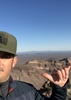
Woolsey Pk/Gila Pk BM/GCRCZO, AZ
| | |
| |
|
| Hiking | 3.42 Miles |
1,940 AEG |
| | Hiking | 3.42 Miles | 6 Hrs 34 Mns | | 1.15 mph |
| 1,940 ft AEG | 3 Hrs 36 Mns Break | | | |
|
|
| |
| Partners |
|
none
[ show ]
| no partners | | Woolsey Peak - Named after an 1800s, Arizona pioneer.
Gila Peak Benchmark (1949) - Named after a previous BM (1910) of the same name.
GCRCZO - Is a Geocache placed on the peak.
The Wilderness - Does not include the road north of Woolsey.
This was an excellent, and very fun hike.
I did alot of research on everything "Woolsey", including reading the HAZ description from 2002, reading every triplog (12), and viewing every photo published on Haz. I even read a bit on other sites to round off my knowledge.
Conclusion:
(1) - Some hikers are having issues on how to drive 'close' to the peak, and
(2) - The routes (and distances) up and down the peak are all over the place.
Alot of the stuff I read gave me pause.
HA - Here's an example - I read the 2002 HAZ Woolsey Peak description - and I quote:
"Do not attempt this peak from the north face. It was five hours of sheer hell."
Well after I read that, I DID go up the north face, just like Chumley, Johnlp, and Trekkin_Gecko did on 8 May 2016. I trust those seasoned hikers.
Their info was the best, and I had no issues going up or down. I'm no trail blazer (well, sometimes I have to be). I followed the official HAZ route (Chumley's) and had no issues.
I also investigated the north wilderness boundary. Chumley had located some markers that gave a good clue that the final road to the peak, is not actually in the wilderness.
(We can't use motorized vehicles in a wilderness).
I have included a map (in my photo set) that verifies the road is OK to use.
I drove south, all the way to the end of that road, and started the hike. From there, you quickly start going "up" the north face.
Basalt boulders, vegetation, scree, and steepness - Were all doable. I certainly huffed and puffed alot, but made it up easily.
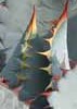
The top is full of 'stunted' cholla. The soil must be really poor. Although the cholla is mostly avoidable, someone made walking paths all over the the top.
Gila Peak BM and its two reference marks were easily located, as was the summit log.
There's a geocache up there also. I don't 'geocache' for a living, but if there's one, way up on a peak, I'll respect the geocacher that went to the trouble of placing it, and try to locate it. The geocache ammo can was far from the area hikers stroll on this peak, but still was an easy find.
After photos and lunch, I went back down the same way I hiked up. The initial part of the 'down' hike is extremely steep, and I tested each boulder before using it. I wanted to make good time, but I didn't want to 'pirouette' down that north face.
I highly recommend Woolsey, as a great off-trail romp.
|
| _____________________
Not All Those Who Wander Are Lost
J.R.R.TOLKIEN |
| | |
|
|
|
 Route Editor


 . And I saw a pair of Peregrine Falcons swirling near the east end of summit where I presume they were nesting.
 But too quick for my photography skills.