|
| | | |
| |
|
| Hiking | 4.83 Miles |
1,720 AEG |
| | Hiking | 4.83 Miles | 1 Hour 55 Mns | | 2.52 mph |
| 1,720 ft AEG | | | | |
|
|
| |
| Linked |
|
none
[ show ]
| no linked trail guides |
| Partners |
|
none
[ show ]
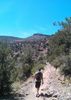
| no partners | | Started from the 40th St. TH and did an over and back. Got there around 6:30 to a full parking lot. Took the Peak 2429 trail (apparently also known as Two Bit Trail. There was a a trail post 1/3 of the way up the mountain with "Two Bit" spray painted on it. Looked legit....or at least it was well done) up the west side. I had actually done this same hike about 5 years ago and I thought I knew where the 2 trails joined. Apparently I misremembered ](https://hikearizona.com/dex2/images/smilies/eusa_wall.gif "Brick wall") . I ended up following a user trail that petered out about 50 yards from where it originated. Note: The saddle north of peak 2429 has a couple of false trail that lead nowhere. The actually "connection" between the two trails occurs about 10 feet below the summit. Anyway, instead of turning back from this dead end trail, I ended up paralleling the side of the mountain until I ran into Dixie 2429. After that, it was fairly smooth hiking. I took the trail down to the cul de sac and then turned around. Encountered 3 people on the east side and about 25 on the west. In my mind the east side is definitely easier and more beautiful. Yeah, you are looking at a bunch of high end homes, but the trail is much more engaging and the mountain geography is eye catching...at least compared to the west side. . I ended up following a user trail that petered out about 50 yards from where it originated. Note: The saddle north of peak 2429 has a couple of false trail that lead nowhere. The actually "connection" between the two trails occurs about 10 feet below the summit. Anyway, instead of turning back from this dead end trail, I ended up paralleling the side of the mountain until I ran into Dixie 2429. After that, it was fairly smooth hiking. I took the trail down to the cul de sac and then turned around. Encountered 3 people on the east side and about 25 on the west. In my mind the east side is definitely easier and more beautiful. Yeah, you are looking at a bunch of high end homes, but the trail is much more engaging and the mountain geography is eye catching...at least compared to the west side. |
| _____________________
| | |
|
|
|
 Route Editor