username
X
password
register
for free!
help
ArticlesGuidesRoutes
 
Photosets
 
 Comments
triplogs   photosets   labels comments more
Navajo Loop - 18 members in 42 triplogs have rated this an average 4.5 ( 1 to 5 best )
1, 2, 3  Next
42 triplogs
login for filter options
May 03 2025
avatar

 Guides 16
 Routes 81
 Photos 1,269
 Triplogs 1,145

51 male
 Joined Apr 30 2008
 Tucson, AZ
Navajo LoopSouthwest, UT
Southwest, UT
Hiking avatar May 03 2025
azdesertfatherTriplogs 1,145
Hiking0.41 Miles 39 AEG
Hiking0.41 Miles      14 Mns   2.05 mph
39 ft AEG      2 Mns Break1 LBS Pack
 no routesno photosets
1st trip
Linked   none no linked trail guides
Partners none no partners
Wanted to hike to Wall Street, but that half of the loop was still under winter closure. So we just walked a few steps down the other part of the loop, then decided to head back.
_____________________
"I went to the woods because I wished to live deliberately, to front only the essential facts of life, and see if I could not learn what it had to teach, and not, when I came to die, discover that I had not lived." — Henry David Thoreau
 
Jul 04 2022
avatar

 Guides 1
 Routes 262
 Photos 864
 Triplogs 266

51 male
 Joined Mar 24 2021
 Tucson, AZ
Queens Garden and Navajo Loop, UT 
Queens Garden and Navajo Loop, UT
 
Hiking avatar Jul 04 2022
JackluminousTriplogs 266
Hiking3.63 Miles 760 AEG
Hiking3.63 Miles   2 Hrs   47 Mns   1.65 mph
760 ft AEG      35 Mns Break
 
no photosets
1st trip
Partners none no partners
Route Scout Route Recorded  on Route Scout | Pop | Map | Popup | MapDEX
Spent the morning at Bryce Canyon with this fun, scenic, and crowded hike. Normally I don’t like crowds but it’s not often that you hear a half dozen foreign languages anywhere in the US so it just added to the fun. We went down Queen’s Garden and returned up Navajo Loop through Wall Street, which is the closest thing Bryce has to a slot. A ranger told us the three tall pines growing in the middle of Wall Street were over 400 years old and get less than two hours of sunlight per day. They were incredible.

The switchbacks out of Wall Street were hot and a little intense for casual hikers, but beautiful looking back.

We walked the rim trail back to the start.

The squirrels are not at all afraid of people so be careful with your snacks. We tried to shoo one off and it wound up jumping in my daughter’s lap before dashing off frustrated and empty-pawed.
 
May 25 2022
avatar

 Guides 9
 Routes 33
 Photos 780
 Triplogs 4,634

44 male
 Joined Nov 25 2008
 Scottsdale, AZ
Navajo LoopSouthwest, UT
Southwest, UT
Hiking avatar May 25 2022
BoonemanTriplogs 4,634
Hiking5.30 Miles 943 AEG
Hiking5.30 Miles   1 Hour   55 Mns   2.77 mph
943 ft AEG
 no routesno photosets
1st trip
Linked   none no linked trail guides
Partners none no partners
Took a nice morning stroll thorugh Bryce Canyon, connecting the rim trail to navajo, down wall street to queens garden and returning along the rim. Loads of people, especially European tourists.
_____________________
 
Aug 23 2021
avatar

 Guides 21
 Routes 1,182
 Photos 36,858
 Triplogs 1,570

69 female
 Joined Feb 26 2004
 Phoenix, AZ
Queens - Navajo Combo Loop, UT 
Queens - Navajo Combo Loop, UT
 
Hiking avatar Aug 23 2021
tibberTriplogs 1,570
Hiking3.73 Miles 795 AEG
Hiking3.73 Miles   2 Hrs   19 Mns   1.82 mph
795 ft AEG      16 Mns Break
 
1st trip
Partners none no partners
Route Scout Route Recorded  on Route Scout | Pop | Map | Popup | MapDEX
Writing trip report on 10-15-2021

Still working my way home I put Bryce on my list of things to see as I've never been there before.  I've always wanted to go when there is snow but, what the heck, it was on my way.  I ended up taking two nites to make it back from Montana and Hatch would be my second and final layover.  I had stayed in Pocatello the nite before so I was able to get to the Park in the early afternoon.  I stopped at the Red Canyon/Dixie Forest VC and did a quick tour before finishing my drive to Bryce.  I stopped at the Lodge to go and find a map and route to choose for a little hike.  The rangers were set up outside so I made an inquiry and the ranger suggested this loop.  Good choice on his part altho he was a little bit arrogant based on our short conversation.

I drove the wrong way so ended up at the Fairyland Loop overview and took a few pictures before heading to the Sunrise Point TH.  Here I also went to the overview first to take a look-see.  I helped some people get a picture they wanted of themselves with just the right background before I headed on my way.  Don't take the Horse Trail as that appears to be an option.  The trail is wide and of course, the scenery is unbelievable in person.  Luckily it was never too crowded which is good so that I could do a lot of filming.  By the way, did you know: Hoodoos (irregular columns of rock) exist on every continent, but here is the largest concentration found anywhere on Earth.

There was one little area that wasn't clear as to which way to go and I backtracked a bit.  I was surprised to go through some people tunnels.  After one of them there is the option to take the dead end trail to the Queen's Garden.  I didn't realize the Queen was in residence in this vicinity.  I went back to the tunnel and continued on the trail into the more shaded and treed area.  You could see where the flash floods had cut through some of the landscape.  The hoodoos are less prevalent down here.
You wander in the lower realm for a bit before beginning your ascent slowly between the canyon walls of the Navajo Loop.  Altho, technically Bryce is not a canyon as it was caused by headward erosion that excavated large amphitheater-shaped features in the Cenozoic-aged rocks of the Paunsaugunt Plateau that exposed delicate and colorful pinnacles called hoodoos that are up to 200 feet high.

It is quite shaded here.  You have the opportunity to check out the twin bridges before you begin the very tight switchback ascent.  Once I was on top and filming, I asked the people below to say hello to youtube; I am always surprised how many people oblige.  It really is an impressive area and even once you're done with the switchbacks you get blown away by huge windows in the rock and Thor's Hammer.  The colors and hoodoos are truly astonishing. I was having a wonderful afternoon and ended up talking with a fellow from Texas that was having a fabulous time as well.  It's nice to see so many smiles. 

It's just too bad so many of these people were hiking this loop the wrong way as it is definitely best to go clockwise from Sunrise Point.  My phone quit filming as it had no more room from all of the previous media of my Montana trip so I had to switch to my camera which doesn't have a great stabilizer; plus I didn't realize the lens had a very slight spot on it, fortunately not too bad though.  (FYI Wall Street was closed per previous storms that had come through)

Sunset Point, of course, had some great views.  I really should have stuck around for sunset but alas, I needed to get to my motel in Hatch in order to get dinner as I wasn't sure how late places would be open around here.  I think I got to Hatch Station within about 1/2 hour.  It's a great little place with a store, restaurant and motel.  The price was $60; the least I paid to stay anywhere.  The owners have had it for a few years and they snowbird in the Valley so are closed for winter.  The room is small but very clean and remote heat/ac control which was a surprise; especially when I tried to change the channel as I would get it mixed up with the tv remote.

Four videos including the stop and drive through Red Canyon:
[ youtube video ]
[ youtube video ]
[ youtube video ]
[ youtube video ]

WATCH: 3.06 from actual start of loop at Sunrise Point 125 avg bpm, max 160. 8409 high, 7774 low burning 758 calories. Starting temp 78.8 and 16% humidity finishing at 5:49PM.
_____________________
For me, sometimes it's just as much about the journey as the destination.
Oh, and once in awhile, don't forget to look back at the trail you've traveled.
 
Jun 05 2021
avatar

 Guides 38
 Routes 182
 Photos 1,602
 Triplogs 232

40 male
 Joined Dec 09 2014
 Gilbert, AZ
Under-the-Rim Loop, UT 
Under-the-Rim Loop, UT
 
Hiking avatar Jun 05 2021
jacobemerickTriplogs 232
Hiking35.68 Miles 6,689 AEG
Hiking35.68 Miles   14 Hrs   51 Mns   3.03 mph
6,689 ft AEG   3 Hrs   4 Mns Break
 
1st trip
Partners none no partners
Route Scout Route Recorded  on Route Scout | Pop | Map | Popup | MapDEX
Wanted to stretch the legs and see some new terrain. Friend suggested Bryce Canyon, so drove up on Friday afternoon and set up a hammock just outside the park entrance for a few hours of sleep.

Road Walk
Parked at Farview Point (~10.5 mile) at 3 and headed south. Didn't see a single car on the road and spent much of the walk with no light, enjoying the epic starry skies above. Reached Rainbow Point in 2 hours and treated myself to a quick breakfast as the eastern horizon reddened up.

Under-the-Rim
After a bit of confusion between Bristlecone and connectors in the mostly-dark forest I found the trail and began the steady drop through a burn area. Trail started in great shape, only a few deadfall, and the northern views of the 'rim' were fantastic in the early light. Some cool construction looping around the sandy slopes. At the bottom the forest came back, giant pines and all, and I was further wowed by the area.

The rest of the trail is a roller coaster, about 13 sandy ridges between 100' and 500'. They were pretty crushing - enough of a climb to get the heart pumping, not enough to gain momentum. The campsites were neat, well-signed areas for food storage & prep far from the tent areas, and less than 5 miles between each one. Between the sandy slogs, numerous campsites, and great forest & views, I soon got the hint that a better way to explore this trail would be a leisurely multi-day outing. Yet I was here with no reservation and a daypack, so I pushed on.

Trail maintenance varied a bit. There was deadfall and some overgrowth, and most of the creeks had significant washout sections. The tread was also solid, well-trod reroutes to avoid deadfall, and cairns were built up near the creeks to aid navigation. Either this is still 'early in the season' or the park might be letting this one go a little for a 'rustic' experience.

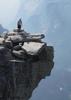
Views up at the rim were always great. There were few hoodoos that define the northern end of the park, it was mostly pretty colors and sharp cliffs. One area that particularly stood up was after a long, hot climb near Whiteman connector, through an exposed burn area, where I hit a saddle and got an epic view down into Mud Canyon. Amazing. Took a few long breaks to gaze around, watered up at Yellow Canyon, chatted with a few backpackers. Some sprinkles and thunder. Eventually reached the climb out, chugged some water, and powered up to Bryce Point. That final stretch through Hat Shop is fantastical.

Peekaboo / Navajo
Wanted to hike through some of the more 'traditional' terrain, plus get some easy water at Sunset Point, so I headed down Peekaboo. Trail is wide and wasn't that crowded, and the creativity the designers used to wind around the ridges was super cool. Wall of Windows & Cathedral were particularly jaw-dropping. Paused at the bottom to polish off my water before connecting with Navajo, which was more narrow and crowded, so I pushed quick up the switchbacks to finish it off. Wall Street area was interesting but better to look at (from Peekaboo) than to hike through IMO. Reached Sunset Point around 5pm and decided to skip Fairyland Loop.

Road Walk pt 2
Took Rim Trail to Inspiration, bike path to road, then started south on the road. This wasn't a good idea. There was a lot more traffic during the daytime, no shoulder to speak of, and no nearby path. If I could make it the few miles to Swamp Canyon then I planned on dropping back down to Under-the-Rim and scooping back up Whiteman. However, after a mile one of the park rangers drove up to me and offered a ride (likely to avoid a pedestrian - vehicle collision) and I happily jumped in. Along the way she pointed out the Mammoth Fire to the west, whose smoke had been drifting over the park most of the afternoon. Got back to the Jeep with a few hours of daylight left and, while it felt sacrilegious to leave so soon, started on the long drive back to PHX.

This park is spectacular. It really beat me up, though, and I'm not sure if the elevation or the sand was the bigger factor. A North-to-South backpack over a few days, complete with a shuttle plan, is preferable, and I can't wait to take my kids up here.
 Named place
 Named place [ checklist ]
[ checklist ]  Hat Shop  Iron Spring

water 1 out of 5water 2 out of 5water less than maxwater less than max Iron Spring Quart per minute Quart per minute
Steady flow, lots of sludgy mud below.

dry Peekaboo Canyon Dry Dry

water 1 out of 5water less than maxwater less than maxwater less than max Swamp Canyon Pools to trickle Pools to trickle
(didn't actually check, two different backpacking groups verified that the water was there)

water 1 out of 5water 2 out of 5water 3 out of 5water less than max Yellow Spring Gallon per minute Gallon per minute
Steady flow out and down the creek, good taste.
_____________________
 
Oct 01 2020
avatar

 Guides 17
 Routes 297
 Photos 1,808
 Triplogs 276

female
 Joined Mar 11 2002
 Gilbert, AZ
Navajo LoopSouthwest, UT
Southwest, UT
Hiking avatar Oct 01 2020
VashtiTriplogs 276
Hiking3.16 Miles 709 AEG
Hiking3.16 Miles   1 Hour   43 Mns   2.23 mph
709 ft AEG      18 Mns Break
 
no photosets
1st trip
Partners none no partners
Route Scout Route Recorded  on Route Scout | Pop | Map | Popup | MapDEX
Lots of people on the trail despite it being a Thursday. I shudder to think what it might be like on a weekend! A beautiful hike, as expected. Loved wall street and all the hoodoos and magnificent colors. We did a combo loop of Navajo loop Wall Street down and Queens Garden trail up. It was pretty hot today, about 86F. Wall Street was very impressive, as were the limber Pines growing in amazingly odd places. We also liked the Queen Victoria hoo doo. She did rather resemble the statue pictured! Great hike!
_____________________
:D
  1 archive
Sep 03 2019
avatar

 Guides 110
 Routes 2,246
 Photos 8,982
 Triplogs 2,600

45 female
 Joined Dec 24 2007
 Ahwatukee, AZ
Navajo Peek-A-Boo, UT 
Navajo Peek-A-Boo, UT
 
Hiking avatar Sep 03 2019
LindaAnnTriplogs 2,600
Hiking6.12 Miles 1,421 AEG
Hiking6.12 Miles   3 Hrs   37 Mns   1.94 mph
1,421 ft AEG      28 Mns Break
 
1st trip
Linked   linked  
Partners partners
realm09
watermelonW
Route Scout Route Recorded  on Route Scout | Pop | Map | Popup | MapDEX
The kids wanted a shorter hike than originally planned, so I told them that if they woke up early, we'd go to Bryce in the morning, then they could sit around the cabin all afternoon. We did part of Navajo Loop last year, and they loved it, so I decided to tack on a little more this time.

We headed down the Thor's Hammer, Two Bridges side of Navajo Loop, did Peek-A-Boo Loop clockwise, then headed back up the Wall Street side of Navajo Loop. Heading down had a handful of people. Peek A Boo had some people, but not a ton. And going up Wall Street was a complete mob scene, as expected.

Saw one Great Basin Rattler on Peek A Boo. He was sleeping next to some benches under an overhang. I warned some hikers walking by at that moment, and they were appalled that there wasn't a sign there warning them of the snake. I said "Well, he moves around, so they'd have to keep moving the sign..." then decided that there was no point in discussing it further. My son also managed to get bit on the finger by a chipmunk (no broken skin). He said it was the best day of his life.

Very warm on the hike up, but the kids handled it better than at least 95% of the other hikers out there. We saw one person who didn't quite make it to the top, and there were park service employees tending to her. Perfect timing for our finish at noon, there was a good sized storm building, and it let loose about 10 minutes after we finished.
_____________________
Stop crying and just go do the hike.
 
Jul 31 2018
avatar

 Guides 3
 Routes 632
 Photos 8,235
 Triplogs 604

54 male
 Joined Apr 13 2011
 Gilbert, AZ
Sunrise Point to Sunset Point Rim TrailSouthwest, UT
Southwest, UT
Hiking avatar Jul 31 2018
ddgrunningTriplogs 604
Hiking3.21 Miles 701 AEG
Hiking3.21 Miles   1 Hour   23 Mns   2.41 mph
701 ft AEG      3 Mns Break
 
1st trip
Linked   linked  
Partners none no partners
Took the whole family reunion group on this most popular loop in Bryce Canyon NP. Most of the group did the shorter Navajo Loop, while my sons-in-law and I extended the loop from Sunset to Sunrise Points. Absolutely no solitude on this trail. There is a reason why this one is so popular. Amazing geology!
_____________________
 
Jul 29 2018
avatar

 Guides 110
 Routes 2,246
 Photos 8,982
 Triplogs 2,600

45 female
 Joined Dec 24 2007
 Ahwatukee, AZ
Navajo LoopSouthwest, UT
Southwest, UT
Hiking avatar Jul 29 2018
LindaAnnTriplogs 2,600
Hiking3.01 Miles 600 AEG
Hiking3.01 Miles   1 Hour   50 Mns   1.81 mph
600 ft AEG      10 Mns Break
 
1st trip
Partners partners
realm09
watermelonW
Early morning hike at Bryce Canyon with the kids. We parked at Sunset Point, did Navajo Loop clockwise, then over to Sunrise Point and back again to the car. It was empty when we started, a mob scene when we finished. The kids, Wyatt especially, loved Bryce Canyon.
_____________________
Stop crying and just go do the hike.
  2 archives
Oct 25 2017
avatar

 Guides 10
 Routes 673
 Photos 7,281
 Triplogs 4,660

67 female
 Joined Nov 17 2008
 phoenix, az
Bryce Canyon National Park TrailsSouthwest, UT
Southwest, UT
Hiking avatar Oct 25 2017
trekkin_geckoTriplogs 4,660
Hiking7.50 Miles 1,600 AEG
Hiking7.50 Miles
1,600 ft AEG
 no routes
1st trip
Partners none no partners
second visit to bryce
started the day with a mile stroll through red canyon
easy to bypass but worth investigating
moved on to sunset point in the park
we did this figure eight last time, along with fairyland and bristlecone loops
picked this one to do again for the variety of trails and views, but fairyland is a good one, too
down queen's garden, the connector to peek-a-boo, up the two bridges part of navajo (saw wall street last time)
great hoodoo scenery and plenty of ups and downs on peek-a-boo
had a snack at inspiration point, scored a cool coffee cup at the visitors center and headed for escalante
stayed in a small cabin at escalante outfitters
they have a gear store and café with wifi, so we spent some time relaxing there
 Named place
 Named place [ checklist ]
[ checklist ]  Thors Hammer
_____________________
hazhole
  3 archives
Sep 20 2017
avatar

 Routes 189
 Photos 7,236
 Triplogs 1,740

57 male
 Joined Apr 25 2011
 Goodyear, AZ
Bryce Figure 8 Combination, UT 
Bryce Figure 8 Combination, UT
 
Hiking avatar Sep 20 2017
NightstalkerTriplogs 1,740
Hiking7.50 Miles 1,987 AEG
Hiking7.50 Miles   3 Hrs   41 Mns   2.57 mph
1,987 ft AEG      46 Mns Break15 LBS Pack
 no routes
1st trip
Started hike about 30 minutes before sunrise from the Sunset parking area. Took the Rim Trail over to Sunrise point which was already crowded with eager beavers looking to catch the morning rays. I caught the sunrise from below the rim on Queen's Garden trail. Took the side trip to see the Queen, but even with my rampant imagination, just saw a pile of rocks. Really didn't see any other hikers until I got on Peek-a-boo (should be Peek-a-horse-poop) trail. Lots of elevation gain and loss on this loop. After completing the loop I headed up the Wall Street side of Navajo Loop, which was absolutely fantastic. Once at the top I dropped down the other side of Navajo Loop to snap some pictures of Thor's Hammer. In my opinion, the best hike in the park. If you only have one day to hike Bryce Canyon, this is the one for you!
_____________________
 
Sep 05 2017
avatar

 Guides 6
 Routes 183
 Photos 5,612
 Triplogs 1,647

male
 Joined Mar 12 2004
 Scottsdale, AZ
Bryce Canyon National Park TrailsSouthwest, UT
Southwest, UT
Hiking avatar Sep 05 2017
John9LTriplogs 1,647
Hiking19.58 Miles 5,639 AEG
Hiking19.58 Miles
5,639 ft AEG
 
1st trip
I started my trip off at Bryce Canyon. I scored a campsite in the North Campground and got myself situated. I would hike a variety of trails over two days in the park and then move on towards Zion. This is my first time in Bryce.

Navajo Loop / Peakaboo Loop
It was late morning by the time I started this multi-loop hike. I headed down the narrow wall section which I really enjoyed. The trail is in excellent condition as it switches down. All of the trails in the park were in amazing condition. I headed down and then detoured to the Peakaboo Loop. The trail makes a respectable climb and then loops around under Bryce Point. The views are just breathtaking. The formations are incredible and the hoodoos are plentiful. I continued on and took a variety of pics as I completed the loop and started heading for Sunrise Point. I made a quick stop at the Queens Garden and then made the final climb out.

Viewpoints & Misc
I spent the evening with a couple of quick stops at Inspiration Point and Bryce Point. There were lots of people out but it wasn't overly crowded. I also took a shower at the General Store ($3 for 8 minutes and then settled in for the evening in my camp.

Fairyland Loop
On day two, I walked right out of my camp and headed for the Fairlyland Loop. I was planning on doing a counter-clockwise loop and wanted to be done around noon. I wasn’t sure what to expect with this trail. I didn’t do any research. I just had GPS routes to follow. So I headed down and cruised to magnificent views that only got better. I continued down and took the short detour over to Tower Bridge which is an impressive formation. From there the trail makes a solid climb as it wraps its way to the NE towards Fairyland Canyon. This section blew me away. The formations are stunning and the colors are vibrant. Every turn brought a new perspective and I was in heaven. This stretch goes on for several miles and then I started my ascent back to the rim. Once up top I admired the section I just hiked through. It’s one of the most visually stunning sections of trail I’ve ever hiked! I would highly recommend! The rest of the hike along the rim was easy going as I looked down on the area I just hiked. A short time later I walked back into my camp to relax. I have a couple more hikes planned for the afternoon.

Mossy Cave
After taking my lunch in camp, I headed north and drove over to the Mossy Cave Trailhead. This is a short hike with a nice waterfall. There were several cars at the TH when I started hiking. The trail parallels a creek in Water Canyon. I walked over to the Mossy Cave which had a steady trickle of water pouring out. After that I headed over to the waterfall which is solid. It’s roughly 20 ft high and had a solid flow of water coming over. After admiring the waterfall I continued a bit up canyon and then turned around and made the hike out. I wanted to drive to the south end of the park and that would take some time.

Bristlecone Pine Loop
The drive to the south end of the park is very pleasant. It’s just under 20 miles with a variety of viewpoints along the way. I arrived and made a loop around the Bristlecone Pine Loop trail. The going is very easy and there are several viewpoints that look down on the valleys below. I was really glad I spent the time driving down here.

I would return to camp and spend one final night and then move on to NW Zion. I greatly enjoyed my time in Bryce and made good use of the time. This park is stunning and the hiking is easy going with incredible views. I highly recommend Bryce!
_____________________
  2 archives
Jun 09 2017
avatar

 Guides 2
 Routes 25
 Photos 1,890
 Triplogs 604

41 male
 Joined Sep 13 2009
 Mesa, AZ
Queen's Garden TrailSouthwest, UT
Southwest, UT
Hiking avatar Jun 09 2017
jochalTriplogs 604
Hiking3.00 Miles 500 AEG
Hiking3.00 Miles
500 ft AEG
 no routesno photosets
1st trip
The trail that goes to Two Bridges was closed for trail damage. Otherwise, good hike.
_____________________
 
Mar 18 2017
avatar

 Photos 99
 Triplogs 872

male
 Joined Mar 18 2012
 Goodyear, AZ
Queen's Garden TrailSouthwest, UT
Southwest, UT
Hiking avatar Mar 18 2017
MikeSTriplogs 872
Hiking3.90 Miles 675 AEG
Hiking3.90 Miles
675 ft AEG
 no routesno photosets
1st trip
Linked   linked  
Partners none no partners
I great loop to experience the Bryce Canyon Amphitheater. Lets you hike through the hoodoos and get up, close and personal. Kids had a great time.

[ youtube video ]
_____________________
Subscribe to my adventure videos at: [ youtube video ]

Follow my adventures on Instagram at: adventures_az
 
Nov 07 2016
avatar

 Routes 39
 Photos 353
 Triplogs 128

37 male
 Joined Sep 30 2015
 Carrboro, NC
Queen's Garden/Navajo Loop UT, UT 
Queen's Garden/Navajo Loop UT, UT
 
Hiking avatar Nov 07 2016
afrankieTriplogs 128
Hiking5.30 Miles 939 AEG
Hiking5.30 Miles
939 ft AEG
 no routes
1st trip
Linked   linked  
Partners none no partners
Bryce Canyon: One of the best hikes I've been on, the loop beginning at Sunrise Point and then immediately descending into the hoodoos via Queen's Garden Loop. In the late afternoon, the sun glowed off the hoodoos - incredible first impression of Bryce. The trail consists of many arched tunnels that escort you through the trail, sometimes serving as door ways to vastly different sceneries on the other side. At the bottom of the descent the trail bottoms out in a lightly wooded area encompassing a couple of washes, linking up with Navajo Trail.

Navajo Trail consists of several up and down switchbacks, offering initial glimpse and then wide views of the Twin Arches above. In this area the hoodoos are above and surrounded by the packed siltstone slopes. On a Monday, approaching dusk, we had the entire trail to ourselves and didn't see anyone on the entire Navajo Trail until Wall Street, near the switchbacks back up to Sunrise Point to complete the loop. (The irony of naming a several million year old geologic feature after Wall Street kills me inside.)

Great loop. Must do in Bryce, and not overly strenuous.
_____________________
Good judgment comes from experience. Experience comes from bad judgment.
Evan Hardin

Footloose adventures are documented instagram @afrankie8.
 
Jun 30 2016
avatar

 Guides 170
 Routes 148
 Photos 5,914
 Triplogs 2,097

48 male
 Joined Apr 12 2004
 Tucson, AZ
Navajo LoopSouthwest, UT
Southwest, UT
Hiking avatar Jun 30 2016
PrestonSandsTriplogs 2,097
Hiking5.15 Miles 1,480 AEG
Hiking5.15 Miles
1,480 ft AEG
 no routesno photosets
1st trip
Linked   linked  
Partners none no partners
Rolling out of Sunset Campground where we had spent the night, we drove out to Sunset Point and began our hike mid-morning with the masses of tourists. We took the Navajo Loop Trail down Wall Street, where numerous obese and bold squirrels approached us for handouts. I was ecstatic at the opportunity to again visit the national park that I had found so incredible as a 14 year old, and my camera was my constant companion. The air was thick with humidity, with patchy cloud cover. When the sun came out, it was a bit toasty. We did a counter clockwise hike on the Peek-A-Boo Loop Trail, and then returned via the eastern side of the Navajo Loop Trail. Menacing thunderstorm clouds were directly above us as we reached Sunset Point, and a few bolts sent us quickly to Shauna's truck. We roamed the super busy Visitors Center for a few minutes, and then made our way out of the park and north toward I-70 on a lonesome highway. Epic visit, and one of my adult goals realized, by seeing Bryce Canyon again.
_____________________
"…you never know when a hike might break out" -Jim Gaffigan
 
Jun 20 2016
avatar

 Guides 11
 Routes 2
 Photos 3,776
 Triplogs 334

48 male
 Joined Jun 09 2009
 Mesa, AZ
Navajo LoopSouthwest, UT
Southwest, UT
Hiking avatar Jun 20 2016
cw50mustTriplogs 334
Hiking3.10 Miles 531 AEG
Hiking3.10 Miles
531 ft AEG
 no routes
1st trip
Linked   linked  
Partners none no partners
This was part of Mighty Five trip 2016. We completed 5 parks in 5 days in Utah.

Day 2 was Bryce Canyon National Park. This was our first time to Bryce and it was great. We started out doing the Navajo Loop tied in with Queens Garden. I had heard this referred to as the best 3 mile hike out there and I have to agree with that. We went down the Wall street section and then came up Queens Garden and connected them with the Rim trail. We did this early, but much of the trail was in the shade still. Found the crowds here to be much smaller than in Zion. I am excited to go back here some day. We stayed the night here again in Bryce.

Video: https://youtube.com ... c9H4
_____________________
 
May 03 2016
avatar

 Routes 17
 Photos 485
 Triplogs 510

77 male
 Joined Jan 07 2010
 Chandler, AZ
Queen's Garden/Navajo Loop, UT 
Queen's Garden/Navajo Loop, UT
 
Hiking avatar May 03 2016
Mike_FelsTriplogs 510
Hiking5.30 Miles 939 AEG
Hiking5.30 Miles   3 Hrs   12 Mns   2.03 mph
939 ft AEG      35 Mns Break
 no routesno photosets
1st trip
Partners none no partners
The Wall Street portion of the Navajo Loop is closed for winter so we combined the Queen's Garden with the Navajo to make a loop. We headed down the Queen's Garden trail (near Sunrise point) and then back up the Navajo (at Sunset point). Okay I'll say right now that supposedly the reason for the Queen's Garden trail is to see the formation that looks like Queen Victoria, if that were the only reason I wouldn't probably cross the road to see it. There is so much more to the Queens Garden trail than this formation. It's a great hike down. 320 feet down and 1.8 miles of fantastic views. Some of the best of Bryce Canyon. Then at the Queen's Garden, eh I could skip it. After all you've just seen it's such a let down. In fact we were over a mile past the Queen then decided we shouldn't skip it and hiked back to see it.

But then from almost the bottom of the Queen's trail the Navajo trail joins in and continues with more great views and some nicely shaded areas of the trail. And of course a series of switchbacks. The whole elevation loss is over 550'.

Then we took the Sunset to Sunrise rim trail to get back to the starting point which is close to the General Store and it's snack bar.
_____________________
 
Mar 27 2016
avatar

 Guides 171
 Routes 253
 Photos 6,100
 Triplogs 1,135

44 male
 Joined Apr 03 2006
 Pocatello, ID
Navajo LoopSouthwest, UT
Southwest, UT
Hiking avatar Mar 27 2016
PaleoRobTriplogs 1,135
Hiking5.00 Miles 320 AEG
Hiking5.00 Miles      45 Mns   8.57 mph
320 ft AEG      10 Mns Break5 LBS Pack
 no routes
Linked   none no linked trail guides
Partners none no partners
Making our way back to Junction, we took the scenic route over Highway 12. We stopped and hiked down to Thor's Hammer at Bryce Canyon, and then over the Boulder for gas and Capitol Reef for photos (arrived too late to really hike). Beautiful drive and I enjoyed being back at Bryce. It was my first time at Capitol Reef, and it marked the last NPS unit in Utah I hadn't visited. So yay!
 Named place
 Named place [ checklist ]
[ checklist ]  Thors Hammer
_____________________
"The only thing we did was wrong was staying in the wilderness to long...the only thing we did was right was the day we started to fight..."
-Old Spiritual
My book, The Marauders on Lulu and Amazon
 
Nov 29 2014
avatar

 Routes 1
 Photos 29,225
 Triplogs 1,447

45 female
 Joined Jan 18 2011
 In the Wild
Navajo LoopSouthwest, UT
Southwest, UT
Hiking avatar Nov 29 2014
LucyanTriplogs 1,447
Hiking1.50 Miles 531 AEG
Hiking1.50 Miles   1 Hour      1.50 mph
531 ft AEG
 no routes
1st trip
Linked   none no linked trail guides
Partners none no partners
_____________________
 
average hiking speed 2.07 mph
1, 2, 3  Next

WARNING! Hiking and outdoor related sports can be dangerous. Be responsible and prepare for the trip. Study the area you are entering and plan accordingly. Dress for the current and unexpected weather changes. Take plenty of water. Never go alone. Make an itinerary with your plan(s), route(s), destination(s) and expected return time. Give your itinerary to trusted family and/or friends.

helpcommentissue

end of page marker