|
| | | |
| |
|
| Hiking | 11.83 Miles |
3,057 AEG |
| | Hiking | 11.83 Miles | 5 Hrs 46 Mns | | 2.05 mph |
| 3,057 ft AEG | | | | |
|
|
| |
| Linked |
|
none
[ show ]
| no linked trail guides |
| Partners |
|
none
[ show ]
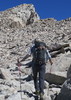
| no partners | | Belated post. This was the second hike of a “daily double.” (The first hike was a short warm up loop at Silly Mountain). Parked just off the 88 on the road to First Water TH. Enough parking for about 12 vehicles. Usually not a problem if you get there early enough. I got there a little after 7am and was the fourth car there. Went in on a user trail that connects to the Jacob’s Crosscut. (Recently discovered that there are two user trails that start from this parking that do this…There distance is practically the same and both connect to the Jacob’s at the same point). I then took the Jacob’s Crosscut over to the Siphon Draw/Flatiron trail. With my “late” start there was already some traffic heading up. But it wasn’t too bad. Felt I did a decent job of “staying on trail.” There seemed to be a lot of “threads” (user trails) intertwining on the way up. The last little scramble to the top seemed more difficult….maybe I’m just getting older  . But I managed. First I headed over to the Flatiron to admire the views. Only some campers (who were beginning to pack up) and five other people were up there so I was able to pick out a semi-isolated spot to enjoy the views. Air quality was good, so there were some decent distant views. Walked a bit to the south side of the Flatiron to get a view of “Weathertop”…kind of like the name…and from this angle, it did kind of look like that and appeared somewhat daunting. I then headed back to where I had scrambled to the top and then continued up and over the saddle. Peak 4648 is visible from the saddle and is really a short jaunt from this point. Used the Ridgeline trail to get close to what turned out to be a very easy and gradual scramble to the top. Now syoung, the author for this hike, climbed to the tallest hoodoo to enjoy the views. I climbed to the tallest rock that I was comfortable on and called it good. Probably “peaked” at 4630 . But I managed. First I headed over to the Flatiron to admire the views. Only some campers (who were beginning to pack up) and five other people were up there so I was able to pick out a semi-isolated spot to enjoy the views. Air quality was good, so there were some decent distant views. Walked a bit to the south side of the Flatiron to get a view of “Weathertop”…kind of like the name…and from this angle, it did kind of look like that and appeared somewhat daunting. I then headed back to where I had scrambled to the top and then continued up and over the saddle. Peak 4648 is visible from the saddle and is really a short jaunt from this point. Used the Ridgeline trail to get close to what turned out to be a very easy and gradual scramble to the top. Now syoung, the author for this hike, climbed to the tallest hoodoo to enjoy the views. I climbed to the tallest rock that I was comfortable on and called it good. Probably “peaked” at 4630  Views were good, but a lot was obscured by the line of hoodoos. Neat views to the east, but the air quality actually appeared worst looking into the sun. Pretty easy Peak to bag if you are not worried about touching the top of the tallest hoodoo. Returned the way I came. Nightmarish going down. Traffic was unbelievable. It explained the numerous and strength of the threads coming up. Views were good, but a lot was obscured by the line of hoodoos. Neat views to the east, but the air quality actually appeared worst looking into the sun. Pretty easy Peak to bag if you are not worried about touching the top of the tallest hoodoo. Returned the way I came. Nightmarish going down. Traffic was unbelievable. It explained the numerous and strength of the threads coming up. |
| _____________________
| | |
|
|
|
 Route Editor