|
| | | |
| |
|
| Hiking | 6.16 Miles |
805 AEG |
| | Hiking | 6.16 Miles | 6 Hrs 18 Mns | | 2.05 mph |
| 805 ft AEG | 3 Hrs 18 Mns Break | | | |
|
|
| |
| Partners |
|
none
[ show ]
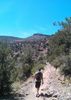
| no partners | | Well, I visited Richinbar Mine Ruins, Richinbar Pueblo Ruins and four little survey disks that have Richinbar stamped on them. All things named Richinbar derive from a guy named Richard N. Barker, who once was associated with the mine.
I first located Richinbar Triangulation Station (1946) and its two reference marks, just west of the mine, atop a little rise. The mine is below and on the opposite side of a little valley. From the benchmark, one gets a great overview of most of the mine area.
I then went south to Richinbar Pueblo Ruins, which was a multi room dwelling with many stone walls separating the rooms. It’s on the edge of the mesa, near a wash that leads to the Agua Fria River.
Next, I hiked to the mine.
Richinbar was a gold mine, with a bit of silver mined also. From reading many accounts, it wasn’t tremendously successful. It was active for over forty years, so obviously the various different owners threw alot of money into the mine, in the hopes of striking it rich. I don’t believe they did.
Mine artifacts are strewn all over the place, and the after-affects of the settling tanks (separating water from the slurry) can be seen down in the wash where the discarded, yucky water ended up discoloring huge rock formations, before eventually going into the Agua Fria River. Parts of the wash are coated with the brownish, rust colored slurry residue. I walked on those rocks and it reminded me of thick, hardened epoxy.
I located some petroglyphs very near the mine, in an area called “Indian Lookout” (named that in a 1934 photo). Indian Lookout overlooks the river and is a good place to see the mine’s ‘other side’.
I wasn’t aware that petroglyphs could be ‘stolen’. I have photos of ‘before-and-now’ that verifies the theft.
I also located what I believe is a small ruin, much further north on the mesa. I’m a true rookie when it comes to ruins. At these northerly ruins, which are right on the edge of the mesa overlooking the Agua Fria River and Perry Mesa, I found more petroglyphs and a couple metates.
Once done with the northerly ruins, I went back to my comfort zone, and searched for the Richinbar Azimuth disk. Luckily, I located it without a lengthy search. The disk (1946) looks brand new.
As I was hiking directly back to the trailhead, I had the surprise of the hike.
A herd of 8 pronghorn were running at high speed, off to my right, and they were coming right at me. When they saw me, they veered off, but still passed within 100 feet in front of me, heading east. They then made a sharp 90 degree turn north, up a dirt road. My guess is, when they turned north on that road, they were moving at 40 to 50 mph. What a sight.
Pronghorn are the fastest mammals in our hemisphere, and can keep-their-speed-up for 20 or 30 minutes. They are true marathoners.
After fumbling to get my stowed camera out, I was lucky to get two photos off before they disappeared. Those 'pronghorn' 15 or 20 seconds were worth as much as the rest of the hike. |
| _____________________
Not All Those Who Wander Are Lost
J.R.R.TOLKIEN |
| | |
|
|
|
 Route Editor


 On my way back, I ran into a snake. Not the creature you want to see when you have 2 miles of off trail hiking left.
 Her eyes were starting to close and she was pouring snot and tears!! I broke out the first aid and got some Benadryl in her. Needless to say we beelined it back to the car. By the time we got to the car she was doing much better and is back to normal now