username
X
password
register
for free!
help
ArticlesGuidesRoutes
 
Photosets
 
 Comments
triplogs   photosets   labels comments more
Bear Mountain Trail #54 - 82 members in 164 triplogs have rated this an average 4.3 ( 1 to 5 best )
1, 2, 3, 4, 5 ... 9  Next
164 triplogs
login for filter options
May 09 2025
avatar

 Guides 4
 Routes 93
 Photos 302
 Triplogs 697

51 male
 Joined Jul 05 2008
 Gilbert, AZ
Bear Mountain Trail #54Sedona, AZ
Sedona, AZ
Hiking avatar May 09 2025
adeniumTriplogs 697
Hiking6.17 Miles 2,100 AEG
Hiking6.17 Miles   4 Hrs   41 Mns   1.32 mph
2,100 ft AEG
 no routesno photosets
1st trip
Linked   none no linked trail guides
Partners none no partners
Took a day off to do my annual Sedona trip. This one kicked my butt. Spent a little time on top abusing my legs tryijg to get a decent view down into Boynton Cyn. Great time, though.
_____________________
 
Apr 02 2024
avatar

 Guides 13
 Photos 15,617
 Triplogs 323

male
 Joined Oct 23 2010
 mesa
Bear Mountain Trail #54Sedona, AZ
Sedona, AZ
Hiking avatar Apr 02 2024
gummoTriplogs 323
Hiking5.83 Miles 2,107 AEG
Hiking5.83 Miles   3 Hrs   24 Mns   1.87 mph
2,107 ft AEG      17 Mns Break
 no routes
1st trip
Linked   none no linked trail guides
Partners none no partners
Clear day with Goldie Locks temperatures for folks who can't stand being uncomfortably warm or cold.

Tough hike. The damp ground offered better traction and less dusty. It was a fun hike and wasn't crowded, but it wasn't my type of hike.
_____________________
 
Apr 08 2023
avatar

 Routes 6
 Photos 31
 Triplogs 21

26 female
 Joined Jun 21 2022
 Tempe, AZ
Bear Mountain Trail #54Sedona, AZ
Sedona, AZ
Hiking avatar Apr 08 2023
ktcrossTriplogs 21
Hiking5.09 Miles 2,157 AEG
Hiking5.09 Miles   2 Hrs   45 Mns   2.04 mph
2,157 ft AEG      15 Mns Break
 
no photosets
1st trip
Linked   none no linked trail guides
Partners none no partners
Route Scout Route Recorded  on Route Scout | Pop | Map | Popup | MapDEX
8am start on Easter weekend. Very busy, parking lot full. Passed 15 people on the way up, few more coming down. Nice to see snow packed Humphrey’s from the top. Only lost trail going up once.
_____________________
It is how you live it.
  2 archives
Oct 09 2022
avatar

 Guides 2
 Routes 207
 Photos 93
 Triplogs 204

male
 Joined Aug 08 2020
 Phx az
Bear Mountain Trail #54Sedona, AZ
Sedona, AZ
Hiking avatar Oct 09 2022
ScaredyCatTriplogs 204
Hiking6.97 Miles 2,482 AEG
Hiking6.97 Miles   7 Hrs   17 Mns   1.22 mph
2,482 ft AEG   1 Hour   35 Mns Break
 
no photosets
1st trip
Linked   none no linked trail guides
Partners none no partners
Route Scout Route Recorded  on Route Scout | Pop | Map | Popup | MapDEX
Hiked up with a very fit female. We made it to the trail end in just 2 hours. From there it slowed to a snail's pace. The track went straight through horribly thick brush. I went around to avoid some but also added distance.

The brush was constantly untieing my boots. Never had this happen before. There are some views along this portion. No registry cuz point 6506 is still not the summit! That would be a lengthy, intense adventure. Some day...
 
Apr 24 2022
avatar

 Routes 228
 Triplogs 215

36 male
 Joined Sep 05 2014
 Phoenix, AZ
Bear Mountain Trail, AZ 
Bear Mountain Trail, AZ
 
Hiking avatar Apr 24 2022
FrostshocknoobTriplogs 215
Hiking5.00 Miles 2,256 AEG
Hiking5.00 Miles   3 Hrs   44 Mns   1.56 mph
2,256 ft AEG      32 Mns Break
 
no photosets
1st trip
Linked   linked  
Partners none no partners
Route Scout Route Recorded  on Route Scout | Pop | Map | Popup | MapDEX
_____________________
 
Feb 12 2022
avatar

 Routes 167
 Photos 973
 Triplogs 130

male
 Joined Mar 17 2021
 Phoenix, arizona
Fay Canyon Overlook, AZ 
Fay Canyon Overlook, AZ
 
Hiking avatar Feb 12 2022
JackArizonaTriplogs 130
Hiking5.10 Miles 1,179 AEG
Hiking5.10 Miles   3 Hrs   39 Mns   1.56 mph
1,179 ft AEG      23 Mns Break
 
1st trip
Linked   linked  
Partners none no partners
Route Scout Route Recorded  on Route Scout | Pop | Map | Popup | MapDEX
 
Aug 01 2021
avatar

 Guides 1
 Routes 57
 Photos 1,122
 Triplogs 64

70 male
 Joined May 29 2013
 Oakland Gardens,
Bear Mountain Trail #54Sedona, AZ
Sedona, AZ
Hiking avatar Aug 01 2021
roaminghikerTriplogs 64
Hiking6.48 Miles 2,496 AEG
Hiking6.48 Miles   6 Hrs   3 Mns   1.19 mph
2,496 ft AEG      35 Mns Break
 
Linked   none no linked trail guides
Partners none no partners
My memory of Bear Mountain held through pandemic hiatus. That memory? That Bear Mountain challenges, yes, strains, yes, but just as assuredly invigorates and enlivens. And that is what I experienced on my hike, a bit of a challenge but a lot of invigoration.

I started out early morning, 4 am, with head lamps, plus a Velcro wrist-strap flash light. I love my wrist-mounted light. Its tight, sharp beam allows me to scan out into the distance for trail makers and directions, while the head lamp still keeps the ground in front lighted. And I love an early morning start. It gets me going in the peacefulness of essentially complete solitude (I do enjoy meeting the people I see later, but early morning is for solitude). And the darkness gets me good progress, since I can’t stop for photos or scenic viewing (plenty time for that later.)

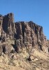
Now the trail. The initial section, flat, with a few ravines, of course just teased. That section bears no resemblance to the rest of the trail. Soon enough, the trail rose, steeply, one might say unforgivingly, through rugged red rock, climbing up unevenly in multiple series of stair-stepped boulders, the trail itself turning back and forth . As noted, a bit challenging, but I fell into a rhythm, step up by step up, pace moderate, my circle of light against the darkness. I felt a sort of oneness with the terrain and the mountain.

As I progressed, the trail did give a respite as a relative flat section emerged, but then as the sun hinted its presence, more steep climbs. At some point, didn’t note exactly, the red, rugged rock becomes sloped, angled slices of white and tan sandstone. I am amazed to think of ancient mountains, hundred of millions of years ago, weathering into sand, and that sand blowing across beaches and deserts, millennium after millennium, building up year after year, forming sand dunes, and the sloping dunes being compressed across eons into the slanted lines of rock so prominent now in the upper reaches of Bear Mountain.

I reached the top. From that vantage, one can see west and northwest, across an expansive vista. I noted something not noticed so much before – the strong, dark mountains beyond Sedona, with what I take as Black Mountain and Casner Mountain in my view, as well as the basin of Sycamore Canyon. Awesome, in a different way then the red rocks, but still spectacular.

Back down now, camera in hand. Now, one drawback of an early morning ascent. Haze to the south and east. As the sun rose, the view south and east from the summit filled with a summer haze. And back shadows on the vistas. Since the sun sits south, looking south from the summit meant I was looking at the north side of the mountains to the south, a north side in deep shadow. Result. The haze plus shadow dimmed and diminished the view of the traditional Sedona sites, i.e. Capital Butte, Cathedral Rock, and the other mountains and formations.

But no mind. I took a closer focus, noticing and photographing the slanted, flowing lines of the sandstone, under foot and in my foreground and at my side. And catching the intriguing way trees and vegetation clung to these sandstone formations. Sometimes a single pine would take root, other times clumps of trees and bushes found an indentation or flat on which to grow. And I thought of the the amazing time lines. The cycle of life for for the vegetation lasts mere seconds, when compared to the time line of the geologic cycle of sandstone deposition and weathering.

My hike included two side excursions. The first, on a sandstone flat at about 5600 feet, took a semicircle loop west. I had an informal GPS track for a route. But no luck. Could not find any distinct path. But, fortunately, the undergrowth was spread out sufficiently sparse that I could just navigate my own semicircle. That allowed me to get close enough to the western cliff edge to view out in that direction. Again a wide, expansive vista.

The second excursion involved a well-defined, and amazing, “unregistered” trail, but likely reasonably documented across the internet, Faye Canyon Overlook. Distinct, multiple boot prints, my GPS track just about right one, and in the red rocks, this side trail offered a treat worth the effort to take the time to travel down it. The red rocks rose tall, boisterously, rising with great stature. More awaited me on this trail, but I turned back as the trail turned out onto some exposed ledges. I didn’t sense I would have the patience or focus to navigate the ledges, as I don’t have a natural ability to cross exposures.

On my way down, I passed a good number of individuals on their hikes up, exchanging plenty of good morning pleasantries, and for some going over a question or two about the route. And while at my early morning start I saw no other cars, the lot had filled when I finished, as Bear Mountain is a main attraction, as is the companion Doe Mountain.
_____________________
 
May 08 2021
avatar

 Guides 7
 Routes 79
 Photos 2,440
 Triplogs 652

34 male
 Joined Jan 10 2010
 Pomona, CA
Bear Mountain Trail #54Sedona, AZ
Sedona, AZ
Hiking avatar May 08 2021
PatrickLTriplogs 652
Hiking5.00 Miles 2,100 AEG
Hiking5.00 Miles
2,100 ft AEG
 no routesno photosets
1st trip
Linked   none no linked trail guides
Partners none no partners
Finally crossing this one off my wishlist. A nice steady climb with great views throughout. We started climbing a little late in the morning but it was never too crowded. Pretty warm yet breezy toward the end. Beautiful day for a hike!
_____________________
 
Nov 18 2020
avatar

 Photos 4
 Triplogs 4

female
 Joined May 25 2017
 Phoenix, AZ
Bear Mountain Trail #54Sedona, AZ
Sedona, AZ
Hiking avatar Nov 18 2020
Pixie87Triplogs 4
Hiking5.00 Miles 2,100 AEG
Hiking5.00 Miles
2,100 ft AEG
 no routesno photosets
1st trip
Linked   none no linked trail guides
Partners none no partners
A little more busy than I expected..but yet again it is Sedona and it is 2020 :lol:
Great hike to get the heart pumping.
_____________________
 
Nov 06 2020
avatar

 Guides 93
 Routes 397
 Photos 4,984
 Triplogs 4,124

49 male
 Joined Jun 20 2003
 Tucson, AZ
Bear Mountain Trail #54Sedona, AZ
Sedona, AZ
Hiking avatar Nov 06 2020
fricknaleyTriplogs 4,124
Hiking5.00 Miles 2,057 AEG
Hiking5.00 Miles   2 Hrs   43 Mns   1.96 mph
2,057 ft AEG      10 Mns Break5 LBS Pack
 no routes
1st trip
Linked   none no linked trail guides
Partners none no partners
had time to sneak in one more hike before heading home. i believe i last hiked this 16 years ago? certainly did not remember much

what a wonderful short, tough hike.
_____________________
hi
 
Sep 21 2020
avatar

 Guides 69
 Routes 37
 Photos 3,010
 Triplogs 2,387

55 male
 Joined Oct 24 2010
 Phoenix,Az
Bear Mountain Trail #54Sedona, AZ
Sedona, AZ
Hiking avatar Sep 21 2020
mt98dewTriplogs 2,387
Hiking5.34 Miles 2,100 AEG
Hiking5.34 Miles   2 Hrs   49 Mns   1.90 mph
2,100 ft AEG
 no routesno photosets
1st trip
Linked   none no linked trail guides
Partners none no partners
Second hike of the day. Hit the Bear Mountain trail around 8am. This hike has been on my radar for awhile now. The beginning of the trail is very obvious as you hike nearby trails and I've always wondered where the trail went. Today I found out. Parking at the TH can accommodate about 12-15 cars. There were already 5 cars there when I arrived. Surprising for a Monday morning. This TH has picnic tables and restrooms and is therefore one of Sedona's pay to use TH. There is a sign at the beginning of Bear Mountain trail that this is an unmarked wilderness trail. That may have been the case years ago, but nowadays the trail is well defined and has arrows leading you all the way to the top.

In my mind the hike can be broken down into 5 climbs. The first climb, is the one the I could see from the nearby trails. It switchbacks up the slope and cuts through the first wall. I always find it amazing how these trails can find a path, where it seems no trail should exist at all. From a distance this doesn't seem like much of a climb, but it will get your heart pumping and is good indicator on what to expect with the other 4 climbs. This first shelf that you reach is one of the nicer parts of the hike. You are in the "red rock zone". So there is a towering wall above and some nice rock formations to view as you make your way to the next climb. Because of the towering walls, if you are doing this hike early or late enough in the day this might be your last chance for shade. The rest of the hike is very exposed to the elements. I was lucky to still be early enough to enjoy the shade one last time before my second ascent. This climb is as much as a scramble as it is a climb. I tried to stay on the trail and follow the arrows, but I still ended up following other user paths that twined around the main trail. Reaching the second shelf is an accomplishment. Views are ok and you have a large shelf to explore if you are so inclined. But you are still less then half way to your objective. :sweat: This second "shelf" is really more of a hill that you have to climb....a maze of manzanita, dotted with scrub pine. When you reach the top of the hill, you get a good look at the rest of the climb. A little intimidating, but very cool looking! This third stage of climbing is very unique in that it is composed of large slanted slabs of rock. Nice in that it is not really "staired" so I was not having to lift my foot up to the next step, but it definitely had an upward tilt. I was alittle worried about the return about traction on these slabs, but it wasn't a problem. (Not sure if I want to do this in wet weather though). The third shelf provides a brief respite before the next climb. I believe there was a lone pine tree (this tree could have been on the fourth shelf) which gave limited shade. There were great views on both the east and west side of the mountain. Fourth climb, probably my favorite part of the hike. Very similar to the third climb, though it seemed shorter. Probably, in part, because of the views which were amazing! :D Red rock formations are fantastic and you get the unusual view of looking down at them. In my opinion the fourth shelf has the best views of the hike. I would say you could stop there because you have the best views on the mountain, but you are so close to the top that it would be a shame not to bag the peak. Plus, this fifth climb, is the easiest of the climbs, though it may not seem like it after having done the previous four. Ironically, it composed mainly of dirt (the first four were very rock oriented) and it has some gradual inclines and switchbacks as it takes you to the western side of the peak. There is a marker at the top that says "trail end", which is nice. (I wish Munds Mountain had a marker like that :lol: ). The peak is more of a dome with vegetated "pathways". I walked around a little, mainly on the west side, before beginning the return trek. I think the views would have been incredible, but the haze really diminished the views :( The nearby views were still amazing, but the layers of Sedona were lost.

Wildlife was minimal...a chipmunk and a few lizards. Didn't see anyone until I was heading down, where I encountered 12 hikers making the attempt.
_____________________
 
Aug 26 2020
avatar

 Photos 5
 Triplogs 1,041

36 female
 Joined Oct 04 2012
 Phoenix, AZ
Bear Mountain Trail #54Sedona, AZ
Sedona, AZ
Hiking avatar Aug 26 2020
WaitingForRainTriplogs 1,041
Hiking5.00 Miles 2,100 AEG
Hiking5.00 Miles   5 Hrs      1.00 mph
2,100 ft AEG
 no routesno photosets
1st trip
Linked   none no linked trail guides
Partners none no partners
I don't think I've ever hiked this slow. My friend wanted to bring her dogs (which I had reservations about, but she assured me it would be fine). It was not fine. We went so slow going up (with a 6am start) that it got super hot as we came down, ran out of water, and the poor pups were so overheated and tired. Luckily, her husband met us with some water as we descended and everyone was safe. Talk about stressful though.

In short, I assume most people here wouldn't, but don't bring your doggos on this trail in the summer (or maybe ever? It is so steep!).

All that being said, this is an amazing trail and it might be one of my favorites in Sedona.
_____________________
 
May 22 2020
avatar

 Guides 9
 Routes 33
 Photos 780
 Triplogs 4,634

44 male
 Joined Nov 25 2008
 Scottsdale, AZ
Bear Mountain Trail #54Sedona, AZ
Sedona, AZ
Hiking avatar May 22 2020
BoonemanTriplogs 4,634
Hiking5.00 Miles 2,151 AEG
Hiking5.00 Miles   2 Hrs   53 Mns   1.73 mph
2,151 ft AEG
 no routesno photosets
Linked   none no linked trail guides
Partners none no partners
An absolutely gorgeous day for a hike in Sedona (not that every day isn't), and if felt good to get up North and take in some fresh air. It has been a few years since I hiked Bear and enjoyed everything about it!
_____________________
 
Feb 27 2020
avatar

 Guides 41
 Routes 1,626
 Photos 14,983
 Triplogs 2,760

69 male
 Joined Jan 20 2009
 Far NE Phoenix,
Bear Mountain Trail #54Sedona, AZ
Sedona, AZ
Hiking avatar Feb 27 2020
The_EagleTriplogs 2,760
Hiking4.29 Miles 1,696 AEG
Hiking4.29 Miles
1,696 ft AEG      17 Mns Break12 LBS Pack
 
1st trip
Linked   none no linked trail guides
Partners partners
Topcat
Route Scout Route Recorded  on Route Scout | Pop | Map | Popup | MapDEX
The family was in for the week, from all over, for my daughters wedding.

They all wanted to sample Sedona. With all levels of fitness levels hiking, I needed something with views, out and back and uphill to start, vs. finish. That way they could turn around or sit and wait for the rest of us.

We started with 16 :o at the TH, and 6 made it to the turnaround time, just short of the summit.

All these Midwestern flatlanders hated me for taking them on this climb, but loved me for the views.
_____________________
There is a very fine line between "hobby" and "mental illness."
Dave Barry 🦅
  1 archive
Nov 02 2019
avatar

 Routes 189
 Photos 7,236
 Triplogs 1,740

57 male
 Joined Apr 25 2011
 Goodyear, AZ
Fay Canyon Overlook, AZ 
Fay Canyon Overlook, AZ
 
Hiking avatar Nov 02 2019
NightstalkerTriplogs 1,740
Hiking3.20 Miles 789 AEG
Hiking3.20 Miles   2 Hrs   37 Mns   1.70 mph
789 ft AEG      44 Mns Break15 LBS Pack
 
1st trip
Linked   linked  
Partners partners
Gallydoll
SCA
Spied a social trail on the google and took the harem up to Sedona to check it out. Started in the brisk morning shadow of Doe Mountain and raced for the sun line up Bear Mountain trail. Followed Bear to the jump off point and found an easy enough to follow social trail. Reminded me of Lost Canyon loop with high drop offs, but not as scary. Enjoyed the views of Fay Canyon from above and retreated back to the trailhead for the loop on Doe Mountain.
_____________________
  1 archive
Sep 22 2019
avatar

 Routes 215
 Photos 1,337
 Triplogs 124

53 male
 Joined May 26 2017
 Phoenix, AZ
Bear Mountain Trail #54Sedona, AZ
Sedona, AZ
Hiking avatar Sep 22 2019
Nate_FTriplogs 124
Hiking5.00 Miles 2,100 AEG
Hiking5.00 Miles
2,100 ft AEG
 
1st trip
Linked   none no linked trail guides
Partners none no partners
Beautiful hike in Sedona! Still pretty warm; I'll come back another time and explore more. So much to see!
_____________________
 
Mar 16 2019
avatar

 Guides 2
 Routes 267
 Photos 9,816
 Triplogs 402

62 male
 Joined Dec 02 2014
 Mesa, AZ
Bear Mountain Trail #54Sedona, AZ
Sedona, AZ
Hiking avatar Mar 16 2019
adillingTriplogs 402
Hiking4.85 Miles 2,148 AEG
Hiking4.85 Miles
2,148 ft AEG   3 Hrs   5 Mns Break
 
1st trip
Linked   none no linked trail guides
Partners partners
DarthStiller
SUICIDEKING
wallyfrack
My first trip up this awesome trail. Chris aka DarthStiller invited me for a Sedona hike. We were joined with Mike G and Wally.

An early start and a mostly empty parking lot at the Doe Mountain Trailhead. It was actually a bit chilly at the start, but that did not matter once we started up the "stairmaster" portion of the hike.

I knew this trail had some excellent views and it did not disappoint. There are basically three parts to this hike. The first part is the climb up to the first step. This was a little more steeper and rougher than I was expecting. A clear path, but lots of steep steps to navigate. The second section is a little roller coaster up (mostly) and down to the final section. The best views of Fay Canyon and Sedona came from this area. The third step is the final push to the top of the trail.

The weather was really nice. Mild with no clouds. I would have preferred some clouds for contrast, but you cannot ask for nicer weather than we had this day. The full parking lot I noticed on the way down started showing more and more hikers going up. Not as crowded at some of the more popular hikes in Sedona, but a steady stream going up.

This hike is not even 5 miles r/t, but it really puts you through a workout. Chris and Wally decided to hit Doe Mountain once we got back to the trailhead. All in all an excellent day in Sedona. I will hike with these guys any day!
_____________________
"Jobs fill your pockets, adventures fill your soul."

instagram: @andydilling
 
Mar 16 2019
avatar

 Guides 27
 Routes 669
 Photos 12,096
 Triplogs 856

56 male
 Joined Jul 05 2006
 Mesa, AZ
Bear Mountain Trail #54Sedona, AZ
Sedona, AZ
Hiking avatar Mar 16 2019
DarthStillerTriplogs 856
Hiking7.70 Miles 2,579 AEG
Hiking7.70 Miles   6 Hrs      1.28 mph
2,579 ft AEG
 
1st trip
Linked   linked  
Partners partners
adilling
SUICIDEKING
wallyfrack
I wanted to do another hike in Sedona. I asked Andy if he was interested and he said yes. He suggested Bear Mountain. I had never done that, so I was game for that one. It's a pretty short hike for a long drive, so I suggested we add Doe Mountain as well, and maybe even a 4 mile loop of the Cockscomb Trail around Doe Mountain. Andy recently got a new hiking vehicle and even graciously offered to drive, which I gladly accepted.

While Bear Mountain is a short hike, it has a lot of elevation gain and is pretty steep. There are also a lot of high steps that have to be taken to get up the trail. Good workout and as usual, amazing views all around Sedona. It was chilly in the morning, and windy, but the heat of exertion and the sun was warmth enough. The views at the top of the other side of the mountain were great, as well as a nice view of the San Francisco Peaks with snow and some wispy clouds around the peaks. The lighting was better on the way back down the mountain, so I had better pictures of that. Not many hikers on the way up, but quite a few on the way down.

Once we got back to the trailhead, the lot was full (as usual), and cars were parked along the road. Andy and Mike were spent from the ascent up Bear Mountain, so it was just Wally and I doing Doe Mountain. By the time I got to the top of Doe Mountain, Wally was already on his way down. He took the trail to where the last marker is and turned back. I decided to follow the loop around the top of the mountain, which is fairly faint and not maintained as an official trail. This took about an extra half hour or so, but the views along all the edges were really nice.

I got back to the trailhead a little after 2pm. Wally had just started to hike back up the trail to see if something happened to me since he wasn't aware of the loop at the top. I suggested the 4 mile loop around the mountain, but was quickly shot down in flames.

My AEG that RS measured for this hike was not even 2600'. Joe and Bruce did this same hike previously and their routes show over 3600'. This definitely felt closer to 3600 that under 2600, so I'm going with that as my stat for this hike. I've noticed lately that it seems Route Scout might be underestimating my AEG. Definitely noticed some kind of issue on my hike last week.

The ride back on I-17 was very nice. Not the crazy Sunday return traffic to Phoenix. It looks very different now with all the green along the highway and the surrounding mountains. Thanks to Andy for driving and choosing a nice hike.
_____________________
  3 archives
Mar 15 2019
avatar

 Photos 2,351
 Triplogs 99

53 male
 Joined Jan 31 2015
 Chandler, AZ
Bear Mountain Trail #54Sedona, AZ
Sedona, AZ
Hiking avatar Mar 15 2019
OdinWiskiTriplogs 99
Hiking6.09 Miles 2,530 AEG
Hiking6.09 Miles   5 Hrs      1.35 mph
2,530 ft AEG      30 Mns Break
 no routes
Linked   none no linked trail guides
Partners none no partners
Bro-in-law and his wife were in town visiting from MN to escape from the cold and snow. We thought this would be a nice hike for them that was not too long but offered a nice workout and iconic Sedona views. It did not disappoint. Last time we did this it was a lot warmer for Wiski. This time it was cooler and super windy although she was a couple of years older now at 11.5 and all the rock hopping was not that forgiving on the back and hind legs. She got up on top just fine, but we saw quite a number of dogs on the trail and none got to the top. We roamed on the summit for about 30 minutes before heading back down to the car. Afterwards, we took them to the GC South Rim for sunset and sunrise views. The wind on the Rim was brutal Saturday morning.
_____________________
 
Jan 14 2019
avatar

 Photos 104
 Triplogs 47

32 female
 Joined Oct 17 2016
 Phoenix
Bear Mountain Trail #54Sedona, AZ
Sedona, AZ
Hiking avatar Jan 14 2019
peculiargalexyTriplogs 47
Hiking4.80 Miles 2,100 AEG
Hiking4.80 Miles   3 Hrs   40 Mns   1.31 mph
2,100 ft AEG
 no routesno photosets
1st trip
Linked   none no linked trail guides
Partners none no partners
3/52

One of the most stunning hikes I have been on in Sedona. The trail up was incredibly nice. I was expecting it to be more like Thunder Mountain and it wasn't. Not sure why since Thunder Mountain doesn't exactly have a trail and Bear Mountain does, but I guess the look similar enough :-k But the views on this blew my mind. I loved seeing Boynton Canyon from the top and it brought back awesome memories of being down in that canyon and how amazing that hike was as well. Sedona continues to surprise me and I cannot wait to find more hikes to do there. Now if only the government can start working again so that I can buy my annual red rock pass :D
_____________________
 
average hiking speed 1.53 mph
1, 2, 3, 4, 5 ... 9  Next

WARNING! Hiking and outdoor related sports can be dangerous. Be responsible and prepare for the trip. Study the area you are entering and plan accordingly. Dress for the current and unexpected weather changes. Take plenty of water. Never go alone. Make an itinerary with your plan(s), route(s), destination(s) and expected return time. Give your itinerary to trusted family and/or friends.

helpcommentissue

end of page marker