username
X
password
register
for free!
help
ArticlesGuidesRoutes
 
Photosets
 
 Comments
triplogs   photosets   labels comments more
Sugarloaf - Sedona - 5 members in 15 triplogs have rated this an average 3.4 ( 1 to 5 best )
15 triplogs
login for filter options
Mar 09 2025
avatar

 Guides 10
 Routes 673
 Photos 7,281
 Triplogs 4,660

67 female
 Joined Nov 17 2008
 phoenix, az
Sugarloaf - SedonaSedona, AZ
Sedona, AZ
Hiking avatar Mar 09 2025
trekkin_geckoTriplogs 4,660
Hiking7.26 Miles 763 AEG
Hiking7.26 Miles
763 ft AEG
 
Linked   none no linked trail guides
Partners none no partners
mid morning hike through town to sugarloaf loop trail and summit
late morning a two and a half mile walk just west of uptown sedona with my mom and my brother
scenic drive up oak creek canyon and lunch at martanne's in flagstaff
easy drive home, thankfully
nice day :)
_____________________
hazhole
 
Apr 25 2024
avatar

 Guides 10
 Routes 673
 Photos 7,281
 Triplogs 4,660

67 female
 Joined Nov 17 2008
 phoenix, az
Thunder Mountain Sampler, AZ 
Thunder Mountain Sampler, AZ
 
Hiking avatar Apr 25 2024
trekkin_geckoTriplogs 4,660
Hiking6.51 Miles 1,054 AEG
Hiking6.51 Miles
1,054 ft AEG
 
Partners partners
tibber
Route Scout Route Recorded  on Route Scout | Pop | Map | Popup | MapDEX
Angela invited me on an overnight in Flagstaff, with hikes in sedona before and after
We did this sampler of trails from andante trailhead
Andante, sugarloaf loop, teacup and thunder mountain
We got rain for about a mile of the return, then it cleared
Pretty good storms nearby, so we felt fortunate to get our hike in
Beautiful scenery, cool temps, fresh air and good company
Beer and root beer after the hike, and on to Flagstaff
_____________________
hazhole
 
Apr 25 2024
avatar

 Guides 21
 Routes 1,182
 Photos 36,858
 Triplogs 1,570

69 female
 Joined Feb 26 2004
 Phoenix, AZ
Thunder Mountain Sampler, AZ 
Thunder Mountain Sampler, AZ
 
Hiking avatar Apr 25 2024
tibberTriplogs 1,570
Hiking7.04 Miles 987 AEG
Hiking7.04 Miles   3 Hrs   7 Mns   2.40 mph
987 ft AEG      11 Mns Break
 
Partners partners
trekkin_gecko
Route Scout Route Recorded  on Route Scout | Pop | Map | Popup | MapDEX
My friend Tina from Calgary and several other Glacier Chatters came down to do the Grand Canyon hike. After they came out on the 25th they planned to meet up for dinner in Flagstaff. I persuaded Kelly to come with me and that we could do hiking in Sedona to and from (too cold in Flag for me). Kelly agreed as she also likes hiking in Sedona and wanted to meet Tina.

We drove 89a to the Andante TH. The weather was questionable for the hike but when we got there, it seemed okay enough for us to proceed with our plans. I had spotted two other trails we could do (Skidmark and Coffee Pot) as something different on the route back from Soldier Pass Road. Luckily there were two parking spots left as this is a very small TH. We got to see and hear a Cardinal couple before starting off east on the Andante Trail. When I went to get my camera though, I realized the battery was dead. I don't take my camera often, but Sedona is one of those places it is a necessity, so I wasn't happy with myself ](*,) .

The first thing I spotted was Owl Clover and then a couple minutes later we ran into a lot more of it. However, that was all we saw for the rest of the hike. The flower we would see a lot of and throughout the hike was Blackfoot Daisy. The Andante Trail is pretty nice tread. Then we took the Teacup Trail to Sugarloaf Loop Trail. Next up was Sugarloaf Mountain. It's a tiered climb, but there were wildflowers (including a Delphinium and some Paintbrush) and views (including Chimney and Little Sugarloaf to the west and Mescal to the east) along the way to entertain me while Kelly skated her way up quickly. We hung out here for a short time looking at all the landmarks and the changing sky.

After coming down the mountain, we saw very few other hikers on the rest of our route which was now on the Teacup Trail. There were quite a few Sugar Sumac trees in various levels of budding and blooming. We got to walk on some bedrock and ledges off and on as we made our way toward a closer view of the Coffee Pot. We passed it by and continued to Soldier Pass Road never finding the junctions with the Skidmark Trail; so on the way back, we pulled out RS to try and figure out where the junction was. Note to self: When you add a route, tag the junctions! I just assumed, in this case, that it would be marked. Anyway, after further research, we were almost right at it when we decided it didn't exist :lol: . It is technically an extension from the Coffee Pot Trail.

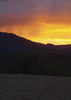
We continued on the Teacup Trail still enjoying our views, the smells, the clouds, the flora when we both saw the clouds turn dark. However, we both saw bright clouds to the west and then boom, the rain started around 12:15PM as we passed a couple groups of hikers. It seemed like it lasted longer than it did. I came down pretty hard for about 10 minutes and it was a bit chilly too. I managed to grab a quick picture. It started to slow as we came to the unmarked junction with the Coffee Pot Trail. I took a picture for future reference.

We heard a few loud claps of Thunder that reverberated against the mountains. We could see pouring rain in the distance and felt lucky that our downpour was short. The trails muddied and watered up here and there, but we continued on with our planned route including the upper Thundermountain Trail. It was quite a treat, we enjoyed it immensely :) . The trail work on this is amazing as well. I took a few pictures of the stone path work. I saw quite a few Feather Daleas, but they are hard to photograph.

We spotted a trio of windows above us so we had to study those for a moment. We continued to enjoy the landmark and near views. With the changing light and clouds it seemed like a different feeling every time you looked up. This is definitely a trail you don't want to rush. We came upon a large bouder setting that I took a few photos of only to find Kelly waiting for me on the other side to get a picture of me with the boulder. She knows I'm not big on pics of me, but she used my "scale" argument so I obliged.

The trail seemed longer than I thought and it had more ups than I knew, but it's all good for me. Chimney Rock came in and out of view. We saw some more flowers and a huge patch of Claret Cups. As we were coming down the last part of it, there were a few people coming up. When we got back down to Tonto 3 the Cardinal came out to greet us. We were sitting in the car drinking our beers when we saw the light come out long enough to light up Coffee Pot and the nearby rockery.

After grabbing a sandwich at Basha's and exchanging texts with Tina at the Grand Canyon we headed up 89a to Flagstaff. We hit a lot of rain. I don't think I've ever driven up 89a, usually down. It really is a nice drive other than the tight hairpin turns. The road is quite wide in those sections. When we arrived in Flagstaff we could see lots of snow on Mount Elden. We both had coffee upon checkin and hung out in the room until Tina and her gang were ready for dinner.
We met them at Beaver Street Brewery. It was fun catching up with those Chatters I knew and new ones I've only met online. Some of the group were flying home the next day, some were going to Death Valley and Dave was going to be doing some biking in Sedona. I was particularly glad that Kelly got to meet them all, especially Tina, since I talk about our adventures so much.


WATCH 6.26 miles, 10:13AM-1:20PM burning 1190 calories, 4542-4993 elevation (seemed like more). 128 avg bpm/161 max. Temp 72.8, windy, cloudy and some rain including a short downpour, 53% humidity.
wildflower observationwildflower observationwildflower observationwildflower observationwildflower observation
Wildflowers Observation Moderate
Prickly Pear with big ears, a few Claret Cup cactus, a few Spreading Fleabane
_____________________
For me, sometimes it's just as much about the journey as the destination.
Oh, and once in awhile, don't forget to look back at the trail you've traveled.
 
Jul 18 2021
avatar

 Guides 4
 Photos 542
 Triplogs 573

46 male
 Joined Oct 19 2010
 Mesa, AZ
Sugarloaf - SedonaSedona, AZ
Sedona, AZ
Hiking avatar Jul 18 2021
Charger55Triplogs 573
Hiking1.20 Miles 350 AEG
Hiking1.20 Miles   1 Hour      1.20 mph
350 ft AEG
 no routesno photosets
1st trip
Linked   none no linked trail guides
Partners none no partners
It was a swimming day, but we squeezed in a short hike. Not a bad choice if you're short on time.
_____________________
"I've driven across deserts, driven by the irony, that only being shackled to the road could ever I be free"
- Frank Turner "The Road"
 
May 27 2021
avatar

 Guides 21
 Routes 1,182
 Photos 36,858
 Triplogs 1,570

69 female
 Joined Feb 26 2004
 Phoenix, AZ
Thunder Mountain Loop plus high points, AZ 
Thunder Mountain Loop plus high points, AZ
 
Hiking avatar May 27 2021
tibberTriplogs 1,570
Hiking5.41 Miles 1,154 AEG
Hiking5.41 Miles   2 Hrs   50 Mns   2.09 mph
1,154 ft AEG      15 Mns Break
 
1st trip
Route Scout Route Recorded  on Route Scout | Pop | Map | Popup | MapDEX
well it's been a few weeks since I've done this so the videos will better tell you the story. I parked at the Andante TH off of Andante Rd which is off of 89. It is a small TH with room for about 8 cars and I think you can park in the vicinity. I barely squeezed Tonto 3 in and worried a little of people getting in and out of their cars but no scratches or notes when I got back so I guess I was okay.

These were all new trails for me and it was lots of fun though a tad warm from time to time. I started the Chimney Rock Loop clockwise. On the Thunder Mountain Trail You soon lose site of the Chimney Rock as its high above you. I headed west at the junction on the Little Chimney Rock Trail toward the Little Sugarloaf for my first high point of the day. You attack this from the NNE side. The climb is steep and a bit slippery and much worse coming down but it's short. The views on top are fabulous of course. With all the hiking we had done this week I could see almost everywhere I had been which would be the case on the Sugarloaf Summit as well.

Once I got down I almost missed the Upper Chimney Rock Trail I wanted to stay on so be mindful you have to backtrack a tad to get back on the Chimney Rock Loop that heads north and east. This, other than the occasional view to some houses, was the prettiest part of the hike as you complete the circle around the chimney which from the west side looks like three fingers. Eventually you reach Chimney Rock Pass and on the way down there are steps here and there. The trail is really quite nice the entire time in this area.

There is one area as you get on what I call the Upper Thunder Mountain Trail where I got a tad distracted and started going up a drainage but quickly realized this was not right. I made my way east admiring the landscape and occasional boulders along the way as well as the blooming prickly pear cactus. It was from the bottom of Chimney Rock pass that I started to encounter a few more hikers. There is some nice construction on this trail. You reach a junction that puts you back on the Thunder Mountain Trail that eventually heads east to the Teacup Trail for a little bit. Once I reached the junction with Sugarloaf I thot you would go straight up that NW side but you actually hike a little further to the Sugarloaf Loop.

At the Sugarloaf Summit sign you head up a fairly nice grade. This is a fun summit and you are rewarded with nice views once again. I was able to see where we were staying and many of the areas I had hiked during the week... lucky me to be able to hang out and hike almost every day. As I got back down I gave thot to hiking the Teacup Trail east but decided it was warmer than I liked so I headed back on the Andante Trail which is a little more scenic than I thot until I took a nose dive to become one with the trail. As I gathered myself I heard a bike rider coming so I yelled "hiker down" so he wouldn't roll over me as it was on a corner. He, along with another hiker, asked if I was okay and it seemed I was. I grabbed a picture of the rock that tripped me, poured water on the scrape on my right arm (yes, the one with the formerly broken wrist of course), got up and finished the hike back to the TH which was less that 1/2 mile away I think.

Anyway, this was a good hike and I wouldn't mind doing it again to finish up the east side of the loop that actually joins up with the Soldier Pass area. It was a lousy morning for photos though. And now to get back to the Hyatt for that morning reward of a beer. Ambika and I had hoped to do a little hike in the late afternoon but Grasshopper Point was closed.

Here are a few videos I made:
Part 1 Chimney Rock Loop and Little Sugarloaf Summit [ youtube video ]
Part 2 completing Chimney Rock Loop/Pass and Thunder Mountain Trail [ youtube video ]
Part 3 finishing off the hike with Thunder Mountain Trail and Sugarloaf Summit and Andante Trail [ youtube video ]
 Flora
 Flora [ checklist ]
[ checklist ]  Yerba Santa
 Culture
 Culture [ checklist ]
[ checklist ]  HAZ - Hike HAZard
_____________________
For me, sometimes it's just as much about the journey as the destination.
Oh, and once in awhile, don't forget to look back at the trail you've traveled.
 
Aug 24 2020
avatar

 Guides 8
 Routes 16
 Photos 183
 Triplogs 144

53 male
 Joined Jan 29 2008
 Paradise Valley/
Sugarloaf - SedonaSedona, AZ
Sedona, AZ
Hiking avatar Aug 24 2020
neilendsTriplogs 144
Hiking1.40 Miles 350 AEG
Hiking1.40 Miles      40 Mns   2.10 mph
350 ft AEG
 
no photosets
1st trip
Linked   none no linked trail guides
Partners none no partners
Route Scout Route Recorded  on Route Scout | Pop | Map | Popup | MapDEX
Nice quick hike from our family home nearby. The views are great. West Sedona on one side; beautiful views of Coffeepot Rock and more on all other sides.

Be careful if you bring dogs: the City of Sedona does a piss poor job of enforcing its leash laws. Total dogs spotted with their owners, unleashed, was 3. One snarled at me. I’ve been hiking this area for a few months now and it’s a regular occurrence.
_____________________
"Facts are stubborn things; and whatever may be our wishes, our inclinations, or the dictates of our passions, they cannot alter the state of facts and evidence." --John Adams
 
Jul 28 2020
avatar

 Guides 69
 Routes 37
 Photos 3,010
 Triplogs 2,387

55 male
 Joined Oct 24 2010
 Phoenix,Az
Sugarloaf - SedonaSedona, AZ
Sedona, AZ
Hiking avatar Jul 28 2020
mt98dewTriplogs 2,387
Hiking2.07 Miles 350 AEG
Hiking2.07 Miles
350 ft AEG
 no routesno photosets
1st trip
Linked   none no linked trail guides
Partners none no partners
After getting settled into our “new home” I did a short hike with Johnny hitting the Sugarloaf vista and then continuing on the loop going CCW. Johnny had knee surgery about 10 months ago so this was nice way to test out the knee. This area can get kind of confusing with all the user trails, but the trails are well signed and it is easy to figure out where you are with all the signage and maps at the junctures. Vista provided a nice look over Sedona, but there were literally 1000’s of flying ants on the butte. Never seen that many at one time. Crazy!
_____________________
 
Apr 29 2019
avatar

 Guides 10
 Routes 673
 Photos 7,281
 Triplogs 4,660

67 female
 Joined Nov 17 2008
 phoenix, az
Thunder Mountain Sampler, AZ 
Thunder Mountain Sampler, AZ
 
Hiking avatar Apr 29 2019
trekkin_geckoTriplogs 4,660
Hiking6.07 Miles 977 AEG
Hiking6.07 Miles   2 Hrs   4 Mns   3.04 mph
977 ft AEG      4 Mns Break
 
Partners none no partners
wanted to get a hike in before it rained
started from andante trailhead around 0645
thunder mountain, sugarloaf loop and summit, teacup to soldier pass, returned on teacup and andante
city visible to the south, but nice scenery everywhere else
enjoyed all of these trails
very few people out that early on a monday morning
saw a javelina in the neighborhood and a coyote near sugarloaf
this combined with the chimney rock loop we did yesterday would make a decent hike
(i'm talking to you, @tibber :) )
had fun with family the rest of the day, too
_____________________
hazhole
 
Feb 03 2018
avatar

 Guides 7
 Routes 19
 Photos 3,021
 Triplogs 191

67 male
 Joined Jun 01 2010
 Mesa, AZ
Coffee Pot Rock TrailSedona, AZ
Sedona, AZ
Hiking avatar Feb 03 2018
paulhubbardTriplogs 191
Hiking3.50 Miles 180 AEG
Hiking3.50 Miles
180 ft AEG
 no routes
1st trip
Partners partners
kplumaz
Right in the heart of West Sedona is the Sugarloaf Trailhead, with multiple offshoots. We started onthe Teacup TZrail, then went up the Skidmark trail, then down the Coffee Poot Rock Trail, then up to the summit of Sugarloaf Mountain. Just love Sedona!!
_____________________
Good judgement comes from experience. Experience comes from bad judgement.
 
Apr 07 2015
avatar

 Guides 10
 Routes 673
 Photos 7,281
 Triplogs 4,660

67 female
 Joined Nov 17 2008
 phoenix, az
Sugarloaf - SedonaSedona, AZ
Sedona, AZ
Hiking avatar Apr 07 2015
trekkin_geckoTriplogs 4,660
Hiking4.00 Miles 500 AEG
Hiking4.00 Miles   1 Hour   16 Mns   3.16 mph
500 ft AEG
 
Linked   none no linked trail guides
Partners none no partners
went for an early morning walk from sugarloaf lodge
up coffee pot and in some neighborhoods
found sugarloaf trailhead by accident
hiked up to the sugarloaf summit
nice views and a cute little hike right in the middle of town
had i found the trailhead sooner, would have done the loop and some other stuff
now i know why the sugarloaf lodge is named that
_____________________
hazhole
 
Oct 18 2014
avatar

 Triplogs 3

64 male
 Joined Oct 02 2013
 Phoenix, AZ
Sugarloaf - SedonaSedona, AZ
Sedona, AZ
Hiking avatar Oct 18 2014
Majesty4Triplogs 3
Hiking1.20 Miles 350 AEG
Hiking1.20 Miles   2 Hrs      0.60 mph
350 ft AEG
 no routesno photosets
1st trip
Linked   none no linked trail guides
Partners none no partners
This was short hike with a group of friends on a sunny Saturday in Sedona. We began the trail from the Teacup Trailhead about 10 AM and made our way counterclockwise along the Sugarloaf Loop. We climbed to the top of the mountain where we enjoyed some wonderful views. Then headed back down to the main trail.
The only wildlife we encountered was a good-sized Horned Lizard. It seems he posed for several people on the trail today!
The trail is relatively well marked with cairns. However, we found ourselves at a road/driveway unexpectedly and had to backtrack to find the trail. There were two other groups who made the same error we did.
The Sedona landscape is wonderful, which makes this a nice trail. The trail itself is clear of rocks and well worn. However, there are a lot of other well-worn paths intersecting the trail, which can get you off course if you're unfamiliar or not careful about where you're going.
_____________________
 
Mar 15 2012
avatar

 Guides 170
 Routes 148
 Photos 5,914
 Triplogs 2,097

48 male
 Joined Apr 12 2004
 Tucson, AZ
Sugarloaf - SedonaSedona, AZ
Sedona, AZ
Hiking avatar Mar 15 2012
PrestonSandsTriplogs 2,097
Hiking1.80 Miles 560 AEG
Hiking1.80 Miles
560 ft AEG
 no routesno photosets
Linked   none no linked trail guides
Partners none no partners
_____________________
"…you never know when a hike might break out" -Jim Gaffigan
 
Nov 23 2011
avatar

 Guides 170
 Routes 148
 Photos 5,914
 Triplogs 2,097

48 male
 Joined Apr 12 2004
 Tucson, AZ
Sugarloaf - SedonaSedona, AZ
Sedona, AZ
Hiking avatar Nov 23 2011
PrestonSandsTriplogs 2,097
Hiking3.00 Miles 729 AEG
Hiking3.00 Miles      56 Mns   3.21 mph
729 ft AEG4 LBS Pack
 no routesno photosets
Linked   none no linked trail guides
Partners none no partners
Hiked out to the base of Coffeepot Rock on my lunch break; went up to the top of Sugarloaf on the way there and on the way back. Great views and a great hike.
_____________________
"…you never know when a hike might break out" -Jim Gaffigan
 
Feb 19 2010
avatar

 Guides 25
 Routes 36
 Photos 2,890
 Triplogs 658

39 male
 Joined May 30 2008
 Peoria, AZ
Sugarloaf - SedonaSedona, AZ
Sedona, AZ
Hiking avatar Feb 19 2010
hippiepunkpirateTriplogs 658
Hiking1.00 Miles 350 AEG
Hiking1.00 Miles      35 Mns   1.71 mph
350 ft AEG
 no routes
1st trip
Linked   none no linked trail guides
Partners none no partners
Scrambled up the slick-rock trying to catch the sunset from the top, thus I knocked off .2 miles off my mileage.
_____________________
My blog: Mountain Tripper
My book: Arizona: A Photographic Journey
 
Aug 08 2009
avatar

 Guides 1
 Routes 3
 Photos 101
 Triplogs 100

male
 Joined Feb 24 2003
 Los Angeles
Sugarloaf - SedonaSedona, AZ
Sedona, AZ
Hiking avatar Aug 08 2009
kiluamTriplogs 100
Hiking1.20 Miles 350 AEG
Hiking1.20 Miles
350 ft AEG
 no routesno photosets
1st trip
Linked   none no linked trail guides
Partners none no partners
_____________________
cut me some slack jack
 
average hiking speed 1.68 mph

WARNING! Hiking and outdoor related sports can be dangerous. Be responsible and prepare for the trip. Study the area you are entering and plan accordingly. Dress for the current and unexpected weather changes. Take plenty of water. Never go alone. Make an itinerary with your plan(s), route(s), destination(s) and expected return time. Give your itinerary to trusted family and/or friends.

helpcommentissue

end of page marker