username
X
password
register
for free!
help
ArticlesGuidesRoutes
 
Photosets
 
 Comments
triplogs   photosets   labels comments more
Buffalo Ridge Loop - 4 members in 14 triplogs have rated this an average 3.3 ( 1 to 5 best )
14 triplogs
login for filter options
Mar 07 2021
avatar

 Guides 21
 Routes 1,182
 Photos 36,858
 Triplogs 1,570

69 female
 Joined Feb 26 2004
 Phoenix, AZ
Buffalo Ridge Park and exploration, AZ 
Buffalo Ridge Park and exploration, AZ
 
Hiking avatar Mar 07 2021
tibberTriplogs 1,570
Hiking2.86 Miles 510 AEG
Hiking2.86 Miles   1 Hour   31 Mns   2.07 mph
510 ft AEG      8 Mns Break
 
1st trip
Partners none no partners
Route Scout Route Recorded  on Route Scout | Pop | Map | Popup | MapDEX
This was the hike I intended to to the day I broke my wrist but I opted for the Thunderbird Park area instead; oh well. So today was the day as it was going to be warm and I didn't want to do a lot. This is about 5 minutes from my house. It is also a frisbee course I think. I didn't really check that part out as I skirted the outer edge of it. Last posted trip report was 2015.

It was warm right off the bat even though the sky had light broken cloud cover. I saw another hiker so I followed her to get to the start of the trail. I hiked it east and then north alongside the housing area. I headed up a slight hill. I noticed a small mountain to the right but there were people there so I continued in the direction I had on RS; besides it wasn't on my route for today. As I came up and over and up I was at the fenced edge of the gravel pit. It was rather interesting to peruse. It does look like they actually cut into the side of Peak 1826 (the northern part of the Ridge).

I made my way around and started up the Ridge but decided it was pretty slippery. I would do okay going up but I am still babying my wrist so I headed back down and decided to go try the other mountain on the east. I was now going into exploration mode. I did a traverse to the top of the little peak at around 1637 feet. There is an interesting naked tree that looks like it was placed between the rocks.

Next it was to try and figure out how to get over to the rock-topped mountain, Peak 1726, where the American flag was flying. I could see a trail so I found my way and followed its faintness to where there was nothing but rocks. I thot there should be a way to get to the flag but I couldn't see anything so I just climbed up the rock🧗‍♀️. Ya I know, not the best thing to do with my healing wing but it was a short way up and the rocks were very solid. I didn't go to the very top as I didn't want to push it. Anyway, looks like there might have been some sort of fencing here. I assume someone is maintaining the flag as it's in good shape.

I carefully made my way down and past a campfire ring with some sort of metal bowl and scattered broken beer glass. I see the topo has a label for the Turkey Track Mine which is apparently on the eastern side; I was on the western side. I did go a little west to see if there was any more trail and there is as it looks like it takes you down toward some houses that are just off Cave Creek Road.

Next up was to check out the labyrinth I had see from the peak across the way. I traced my steps back and then took a left and headed south down what looks to have been an old road. The labyrinth appears to be in pretty good shape and has little brittle bush plants growing here and there with a quartz heart in the middle.

I headed west back up the hill and down the other side to where the trail takes you back to the Park. I decided that this little hike, a revised version, could work for a 'hood walk; altho on my 'hood walks I usually pick up my mail😉.

Well that was fun. I'll come back and get the official summits when my wrist is better healed and hike the western part of the loop too. 77 degrees and 18% humidity at start finishing at 12:18PM and 81 degrees.
_____________________
For me, sometimes it's just as much about the journey as the destination.
Oh, and once in awhile, don't forget to look back at the trail you've traveled.
 
Feb 13 2019
avatar

 Guides 69
 Routes 37
 Photos 3,010
 Triplogs 2,387

55 male
 Joined Oct 24 2010
 Phoenix,Az
Buffalo Ridge LoopPhoenix, AZ
Phoenix, AZ
Hiking avatar Feb 13 2019
mt98dewTriplogs 2,387
Hiking1.93 Miles
Hiking1.93 Miles      45 Mns   2.57 mph
 no routesno photosets
Linked   none no linked trail guides
Partners none no partners
After work. Been awhile since I visited this spot. Hiked up from the south side. Quite a few threads leading up to the first low lying prominence - more than I remember from my previous visit. Once I started the climb to the main summit all the trails seem to tie into one (at least those on the south side). Decent climb to the top. Not a lot of elevation, but fairly straight up. There was a tent up there again, between the two high points. Odd. I was last up here about two years ago and there was tent up there then as well. Might be someone's home or a "get away" spot for some locals :? Whatever, if either....they actually keep it pretty clean up there. I didn't go into the site, but I didn't see any trash lying around. On the descent I went down the northern ridgeline. Trail was more faint on this side, but still followable. Once I made it down to the flatland I used the frisbee golf paths to make my way back to the parking lot. The frisbee course was crowded!! Using those paths could be dangerous if your not paying attention :) . Didn't see any hikers on the "trails" or critters anywhere. Not a great hike, but awfully convenient.
_____________________
 
May 29 2015
avatar

 Guides 69
 Routes 37
 Photos 3,010
 Triplogs 2,387

55 male
 Joined Oct 24 2010
 Phoenix,Az
Buffalo Ridge LoopPhoenix, AZ
Phoenix, AZ
Hiking avatar May 29 2015
mt98dewTriplogs 2,387
Hiking1.81 Miles
Hiking1.81 Miles
 no routesno photosets
Linked   none no linked trail guides
Partners none no partners
Short, after work hike. Went counterclockwise. There are a couple of trails that go up the south side of this mountain. Went over to the quarry and then followed a path that had been cut I to the side of the hill. This portion is relatively flat and brought me near the southern tip. Still on the east facing of the hill I then followed a trail/wash up the side to the first low lying ridge. Walked out to the edge of the ridge and then looking back to the top was able to get a good view of the most common user trail to the top. This leg is short, but fairly steep. At the top discovered someone had set up a tent between 2 of the higher points. Not wanting to disturb them I circumvented their area as I checked out the other high point. Went down the west side side. Not a huge deal. There are many tracks that will get you to the base. Slope is composed of crushed granite so I took my time as I choose my route down. From there I followed 1 of the many frisbee golf trails back toward my starting point. Saw a good size squirrel but otherwise had the mountain to myself (and the camper, though I never saw them). Definitely getting warmer - mid 90's - but the breeze made it very nice.
_____________________
 
Feb 15 2015
avatar

 Guides 4
 Routes 51
 Photos 1,545
 Triplogs 348

86 male
 Joined Sep 24 2004
 Phoenix, AZ
Buffalo Ridge LoopPhoenix, AZ
Phoenix, AZ
Hiking avatar Feb 15 2015
black_toesTriplogs 348
Hiking1.84 Miles 479 AEG
Hiking1.84 Miles   1 Hour   59 Mns   1.62 mph
479 ft AEG      51 Mns Break
 no routes
1st trip
Linked   none no linked trail guides
Partners none no partners
The sole intent on this, my first visit to the park, was to get up to the highest point and return. Just to say I did it. It is not a pretty place. A few small palo verdes and mesquite trees and lots of brittlebush, bursage, creosote and other low-lying plants on a brown, dirt floor. There is a small mountain range on the north end, very rocky and steep, with a few faint, lightly traveled trails and no signage. The route selection to the summit is up to the hiker. The rocky summit rises about 365' above the desert floor. As far as I know it has no name. The elevation, on my GPS and Cal topo, is 1,826.

To start, I walked S back from the parking lot and rec area to the park entrance on Wescott Dr, across the street from North Canyon HS, and found a trail going NE toward some residences. It quickly turned N, crossing through the disc golf course with its baskets and concrete tee pads. Along the east end of the park stretches a quarry with a turquoise pond in a far corner, all fenced off. From there, it was W, up to a small saddle with a sealed shaft mine. The summit "trail" was straight up 100 feet. I saw a guy in an orange vest sitting on top and figured there was an easier way down the other side. No way was I coming down this trail again to the saddle. Tumble city.

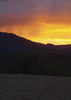
Looking up, I thought it might take 30 minutes to reach the summit so steep was it and filled with loose rock and boulders. I was surprised to reach the top in only 7 minutes from the saddle. The view, though expansive, was nothing to write home about. Homes, the high school, Lookout Mountain to the S and the busy 101-North just below. Saw no one else up high. Shot some photos and headed down. But how? A faint trail headed off toward the little range's other peaks but nothing down. It was 5 o'clock. I couldn't screw around too long looking for a route.

I finally gave up on trails and began bushwhacking down a steep SW face over boulders and loose rock. I could see a clear trail below, one I was sure would lead back to the parking lot. Lucky not to slip and fall, I reached that trail in a tortured 37 minutes. From there it was an easy walk back through the disc golf course where a half dozen or so were slinging frisbees toward the baskets. Doubt I will try this summit again. Good for locals looking for exercise. But, for me, just not worth the effort.
_____________________
  2 archives
Feb 04 2015
avatar

 Routes 36
 Photos 2,658
 Triplogs 1,347

67 male
 Joined Jul 28 2004
 Scottsdale, AZ
Buffalo Ridge LoopPhoenix, AZ
Phoenix, AZ
Hiking avatar Feb 04 2015
mazatzalTriplogs 1,347
Hiking3.00 Miles 450 AEG
Hiking3.00 Miles   1 Hour   10 Mns   2.57 mph
450 ft AEG
 no routesno photosets
1st trip
Went out for two quick walks in an area I had never been to: Buffalo Ridge Park and Scarlet Canyon Park. Nice views of the 101 from both parks :)
Bring your frisbee as there is a 27 hole disc course :)
_____________________
  2 archives
Apr 09 2012
avatar

 Guides 4
 Photos 542
 Triplogs 573

46 male
 Joined Oct 19 2010
 Mesa, AZ
Buffalo Ridge LoopPhoenix, AZ
Phoenix, AZ
Hiking avatar Apr 09 2012
Charger55Triplogs 573
Hiking2.00 Miles
Hiking2.00 Miles   1 Hour   30 Mns   1.33 mph
 no routesno photosets
1st trip
Partners none no partners
...Summited something. The ocotillos on the saddle were greener than anywhere else I've seen. Bright red tips too. There's also a nice quartz outcropping between the northern peaks. Sadly, there's a lot of graffiti up here too. No surprise since it's right behind a high school.
_____________________
"I've driven across deserts, driven by the irony, that only being shackled to the road could ever I be free"
- Frank Turner "The Road"
  1 archive
Jan 30 2011
avatar

 Photos 205
 Triplogs 23

43 male
 Joined Mar 19 2012
 Scottsdale, AZ
Buffalo Ridge LoopPhoenix, AZ
Phoenix, AZ
Hiking avatar Jan 30 2011
mazatzal82Triplogs 23
Hiking2.00 Miles
Hiking2.00 Miles      50 Mns   2.40 mph
 no routes
1st trip
Linked   none no linked trail guides
Partners none no partners
Buffalo Ridge is a solid clump of dirt along the 101 near Cave Creek. On one side is a freeway and the other side... a disc golf course. In between, you get a few miles of hiking with good views from the basic dead center of north Phoenix. There do not appear to be any official routes to these ridges, but well worn paths are certainly etched out. Make sure to be respectful of private property and beware the disc golfers below!
_____________________
 
Jun 25 2010
avatar

 Guides 20
 Routes 81
 Photos 542
 Triplogs 409

60 male
 Joined Feb 02 2010
 Scottsdale, AZ
Buffalo Ridge LoopPhoenix, AZ
Phoenix, AZ
Hiking avatar Jun 25 2010
paulshikleejrTriplogs 409
Hiking2.20 Miles 340 AEG
Hiking2.20 Miles   1 Hour   4 Mns   2.06 mph
340 ft AEG
 
no photosets
Linked   none no linked trail guides
Partners none no partners
Gathering track data (in conjunction with gathering track data for "Buffalo Ridge, Western Prominence".
_____________________
Decisionmaking and action should only be informed by, not subject to, healthy, reasonable concern.
That being said, anything worth doing is worth doing to excess.
 
Jun 24 2010
avatar

 Guides 20
 Routes 81
 Photos 542
 Triplogs 409

60 male
 Joined Feb 02 2010
 Scottsdale, AZ
Buffalo Ridge LoopPhoenix, AZ
Phoenix, AZ
Hiking avatar Jun 24 2010
paulshikleejrTriplogs 409
Hiking2.50 Miles 350 AEG
Hiking2.50 Miles   1 Hour   30 Mns   1.67 mph
350 ft AEG
 
no photosets
Linked   none no linked trail guides
Partners none no partners
First run through postulated trail (with some degree of wandering around). Good to finally be at this stage of the write-up.
_____________________
Decisionmaking and action should only be informed by, not subject to, healthy, reasonable concern.
That being said, anything worth doing is worth doing to excess.
 
Apr 23 2010
avatar

 Guides 20
 Routes 81
 Photos 542
 Triplogs 409

60 male
 Joined Feb 02 2010
 Scottsdale, AZ
Buffalo Ridge LoopPhoenix, AZ
Phoenix, AZ
Hiking avatar Apr 23 2010
paulshikleejrTriplogs 409
Hiking2.00 Miles 350 AEG
Hiking2.00 Miles   1 Hour   20 Mns   1.50 mph
350 ft AEG
 
no photosets
Linked   none no linked trail guides
Partners none no partners
Nice look around today. Found something new. Saw lots of hikers and disc-ers. Little bit of rain to activate the desert scents and cool things off.
_____________________
Decisionmaking and action should only be informed by, not subject to, healthy, reasonable concern.
That being said, anything worth doing is worth doing to excess.
 
Apr 22 2010
avatar

 Guides 20
 Routes 81
 Photos 542
 Triplogs 409

60 male
 Joined Feb 02 2010
 Scottsdale, AZ
Buffalo Ridge LoopPhoenix, AZ
Phoenix, AZ
Hiking avatar Apr 22 2010
paulshikleejrTriplogs 409
Hiking1.75 Miles 250 AEG
Hiking1.75 Miles   1 Hour   30 Mns   1.17 mph
250 ft AEG
 
no photosets
Linked   none no linked trail guides
Partners none no partners
Looking for a loop leg ...
_____________________
Decisionmaking and action should only be informed by, not subject to, healthy, reasonable concern.
That being said, anything worth doing is worth doing to excess.
 
Mar 24 2010
avatar

 Guides 20
 Routes 81
 Photos 542
 Triplogs 409

60 male
 Joined Feb 02 2010
 Scottsdale, AZ
Buffalo Ridge LoopPhoenix, AZ
Phoenix, AZ
Hiking avatar Mar 24 2010
paulshikleejrTriplogs 409
Hiking4.20 Miles 150 AEG
Hiking4.20 Miles   1 Hour   36 Mns   2.63 mph
150 ft AEG
 
no photosets
Linked   none no linked trail guides
Partners none no partners
Looked for a way around the north side of the ridge and got shunted into a neighborhood.
_____________________
Decisionmaking and action should only be informed by, not subject to, healthy, reasonable concern.
That being said, anything worth doing is worth doing to excess.
  1 archive
Feb 24 2010
avatar

 Guides 20
 Routes 81
 Photos 542
 Triplogs 409

60 male
 Joined Feb 02 2010
 Scottsdale, AZ
Buffalo Ridge LoopPhoenix, AZ
Phoenix, AZ
Hiking avatar Feb 24 2010
paulshikleejrTriplogs 409
Hiking1.40 Miles 150 AEG
Hiking1.40 Miles   1 Hour      1.40 mph
150 ft AEG
 
no photosets
Linked   none no linked trail guides
Partners none no partners
First look on the ground.
_____________________
Decisionmaking and action should only be informed by, not subject to, healthy, reasonable concern.
That being said, anything worth doing is worth doing to excess.
  1 archive
Feb 21 2002
avatar

 Guides 1
 Routes 3
 Photos 101
 Triplogs 100

male
 Joined Feb 24 2003
 Los Angeles
Buffalo Ridge LoopPhoenix, AZ
Phoenix, AZ
Hiking avatar Feb 21 2002
kiluamTriplogs 100
Hiking2.00 Miles
Hiking2.00 Miles
 no routesno photosets
1st trip
Linked   none no linked trail guides
Partners none no partners
_____________________
cut me some slack jack
 
average hiking speed 1.92 mph

WARNING! Hiking and outdoor related sports can be dangerous. Be responsible and prepare for the trip. Study the area you are entering and plan accordingly. Dress for the current and unexpected weather changes. Take plenty of water. Never go alone. Make an itinerary with your plan(s), route(s), destination(s) and expected return time. Give your itinerary to trusted family and/or friends.

helpcommentissue

end of page marker