|
| | | |
| |
|
| Hiking | 4.20 Miles |
1,339 AEG |
| | Hiking | 4.20 Miles | 3 Hrs 47 Mns | | 1.32 mph |
| 1,339 ft AEG | 36 Mns Break | | | |
|
|
| |
| Linked |
|
none
[ show ]
| no linked trail guides |
| Partners |
|
[ show ]
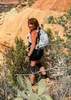
| partners | | This hike with the kids probably needs to go into the ‘WTF was I thinking?’ category. Thought about driving to the upper lot, but it seems silly to drive 90 minutes to hike 2 miles, driving 85 minutes to hike 4 miles is bad enough, so we started from the lower lot around 0745.
Reasonably cool and breezy for the first mile and a half, then we got into a nice section of shade on the steeper part up to the saddle. After a quick break, we headed up to the chute. My daughter was fine with it, but my son was not happy with how close to vertical we were climbing. There were some tears, and he was worried about how he was going to get back down. I told him that there was a slightly easier way down just barely east of where we had come up, and it would be fine. He was also worried because on our way up, he had asked if this mountain was a volcano. I’d told him the rocks looked to be volcanic, so probably yes. He asked if it was extinct, and I said that it had been at least a few years since I’d seen smoke coming out of it. He spent the next hour planning his evacuation route.
After a few minutes at the top, we headed back down, as promised, just slightly east of our ascent for the first 50’ or so of the drop before reconnecting to the main chute. A lot of butt scooting on the way down to the saddle, but no complaints or tears. Once past the saddle, it was smooth sailing, and we decided to follow the road back to the trailhead instead of the actual trail. No difference in mileage, but faster and easier to spot snakes. Very warm for the last mile, but a fun challenge for the kids. |
| _____________________
| Stop crying and just go do the hike. |
| | |
|
|
|
 Route Editor