|
| | | |
| |
|
| Climbing | 8.50 Miles |
4,254 AEG |
| | Climbing | 8.50 Miles | 10 Hrs | | 0.85 mph |
| 4,254 ft AEG | | | | |
|
|
| | |
| Linked |
|
none
[ show ]
| no linked trail guides |
| Partners |
|
none
[ show ]
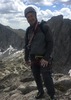
| no partners | | Ah, Baboquivari: one of our state's finest mountains. On this trip, we brought a relatively large group of 6: 2 of which (eric and richard) were to split off and climb the SE Arete, while the other 4 of us were to ascend the Ladder Pitch. The plan was to meet on the summit, descend the Ladder Pitch, and hike down together.
We drove in Friday night, and when I parked at the campsite, I noticed the CR-V was riding pretty low in the back. Flat tire! (well, almost...but it was completely flat by the time we got out). One extra chore to take care of: ah well, just added to the adventure. But there was more! Right as we laid down for an early night, a truck rolled into camp and the two inside knew Richard, Eric, and Alana from previous trips. Small world.
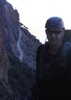
When we awoke in the morning, Richard and Eric took off before us to get a headstart on the Arete, while the other two outside our group - Joe and Devin - asked if they could use our rope and have us belay them up the pitch. Training for Denali means that I'm required to carry heavy packs these days, so they lucked out  At 7 a.m., off our group of four went (Ken, Tanya, Alana, and I) while the other two followed later. We hiked up the beautiful trail and made it to the pitch in about 3 hours. Sidenote: the forest fire burn is extensive on the west approach and that upper forest is heavily charred. At 7 a.m., off our group of four went (Ken, Tanya, Alana, and I) while the other two followed later. We hiked up the beautiful trail and made it to the pitch in about 3 hours. Sidenote: the forest fire burn is extensive on the west approach and that upper forest is heavily charred.
I have to confess: I'd never truly led a full pitch before, but this one was a great starter. It's not difficult, though protection is spotty: I used 2 quick draws on the pitch. I climbed up to the anchor bolts up top and talked through building the anchor with Alana and Ken below. It was actually pretty chilly there in the shade, and I found a nice spot to belay, which was good, since I ended up belaying five people to the top!! Most of our team were pretty chilled, having to stand still for awhile while waiting their turn to climb. The two others had caught up by the time our last climber (Ken) was about to go, so the transition was seamless. All did great on the climb, and we reconvened to finish together.
By this time, Eric and Richard had summitted and scrambled down to check on us. All 8 were now together as we made our way to Babo's expansive summit. Gifts to I'itoi were plentiful, and swallows buzzed our heads. We lounged for awhile, finally leaving by 2 p.m. to start the descent. Joe set up the rappel, and we all made it to the base of the Ladder pitch by 3:30 p.m. That meant the chances of finishing in the dark were slim - nice! Ken and I hoofed it back quickly so that I could start changing the flat a.s.a.p while the rest of the group could enjoy the sunny, breezy, and flower-heavy descent. By 5:00 p.m., Ken and I had the flat changed and cold beers in hand, as we gazed up at beautiful Babo. What a day and great work by the whole team! Now I need to get that SE Arete done... |
| _____________________
| | |
|
|
|
 Route Editor