username
X
password
register
for free!
help
ArticlesGuidesRoutes
 
Photosets
 
 Comments
triplogs   photosets   labels comments more
Bull Basin Trail #40 - Kendrick - 19 members in 79 triplogs have rated this an average 3.4 ( 1 to 5 best )
1, 2, 3, 4  Next
79 triplogs
login for filter options
Aug 18 2025
avatar

 Guides 264
 Routes 2,797
 Photos 14,494
 Triplogs 5,894

55 male
 Joined Nov 20 1996
 
Kendrick - Pumpkin - Bull Basin Loop, AZ 
Kendrick - Pumpkin - Bull Basin Loop, AZ
 
Hiking avatar Aug 18 2025
joebartelsTriplogs 5,894
Hiking18.20 Miles 4,928 AEG
Hiking18.20 Miles   9 Hrs   13 Mns   2.26 mph
4,928 ft AEG   1 Hour   9 Mns Break
 
Route Scout Route Recorded  on Route Scout | Pop | Map | Popup | MapDEX
Kendrick Peak Trail #22
The bottom third of #22 is a wide, ultra-flat pummeled scoria tread. Bruce put the fear of god about potential overgrowth on the connector trail to ponder en route. One deadfall, easy to avoid, and a few knee-high plants had me sweating buckets.

Pumpkin Trail #39
Albeit temporary, views descending this path magically reduce stress. Route finding doesn't draw Bruce hissyfits like #80 because gravity completes him. The short aspen section in the lower third has gained refreshing shade height/density.

Connector Trail #80
Scattered low vegetation will draw blood if not careful. I netted three insignificant scratches, six tops. About a quarter-mile on the west end is a cairn hunt; I checked RS 2 or 3 times for guidance. Nearby pine shade looks refreshing. Clockwise works well to continue along the increasing lure to lunch at the junction with #40.

Bull Basin Trail #40
Fantastic, like any trail that is a walk in the park and makes Bruce whine. The course is the most interesting of the triangular lasso loop. There is enough spaced shade and an easier overall grade vs Pumpkin to entice clockwise votes. Per usual, as much obsidian as I've seen anywhere.

Synopsis
Bruce sent his 4-year-old grandson off in a side-by-side with a chainsaw to bake cookies in the woods so we could hike. Deadfall and thorn encounters overall are forgettable. 18mi/5k at elevation in pleasant weather is tougher for myself than roasting 20mi/5k. Great to hike a quintessential Arizona summer hike with Bruce.
 Culture
 Culture [ checklist ]
[ checklist ]  Point
wildflower observationwildflower observationwildflower observationwildflower observationwildflower observation
Wildflowers Observation Light
Low-lying Wood's Rose galore is not blooming much. Beware the scratch factor and admire the hips.

No time to id the lupine, penstemon, yellows.

dry Bull Spring Dry Dry
water report recorded in the field on our app Route Scout No water or the signature cowpatty waft associated with the spring on this trip
_____________________
- joe
 
Aug 18 2025
avatar

 Guides 41
 Routes 1,626
 Photos 14,983
 Triplogs 2,760

69 male
 Joined Jan 20 2009
 Far NE Phoenix,
Kendrick - Bull Basin - Pumpkin Loop, AZ 
Kendrick - Bull Basin - Pumpkin Loop, AZ
 
Hiking avatar Aug 18 2025
The_EagleTriplogs 2,760
Hiking18.20 Miles 4,958 AEG
Hiking18.20 Miles   9 Hrs   13 Mns   2.28 mph
4,958 ft AEG   1 Hour   15 Mns Break12 LBS Pack
 
Route Scout Route Recorded  on Route Scout | Pop | Map | Popup | MapDEX
We were the third car in the lot, starting our hike at 8:30 a.m. in the low 60s. On our way up, we passed three women, and that was all the hikers we saw that day. This loop has been a go-to escape from the "valley oven" for us over the years.

Kendrick Peak Trail #22
This trail is still in good shape, gaining 2,400 feet in 4.5 miles to the cabin and another 0.5 miles and 300 feet of elevation gain to the peak. Access to the lookout tower is now locked to prevent further damage like what I saw in May.

Pumpkin Trail #39
This trail has some of my favorite views to the north. There is some additional deadfall that you have to navigate, but with a downloaded GPS track and some cairn searching, it's not that difficult to find your way.

Connector Trail #80
This isn't my favorite trail and is the warmest section of the hike. The trail is getting overgrown. Once again, with a track and cairn searching, it's no big deal. At the intersection with the Bull Basin Trail, we took a break and had some lunch before our final climb of the day. Temperatures reached 80 degrees in this section.

Bull Basin Trail #40
The lower third of this trail could use some deadfall removal. This deadfall continues into the areas with the new aspen growth. The trail clearing through here is holding up for the most part, with only scattered deadfall to bypass. The aspens are now tall enough to provide welcome shade for the climb. From the connector trail to the cabin is a 2,000-foot, 3.5-mile climb.

We took a break, gathered our ice-cold, cached drinks, and completed the final slog to the car. We had mostly shade all the way back.
wildflower observationwildflower observationwildflower observationwildflower observationwildflower observation
Wildflowers Observation Light
_____________________
There is a very fine line between "hobby" and "mental illness."
Dave Barry 🦅
 
Jul 26 2025
avatar

 Routes 43
 Photos 2,120
 Triplogs 81

female
 Joined Dec 09 2024
 
Pumpkin Trail #39Flagstaff, AZ
Flagstaff, AZ
Hiking avatar Jul 26 2025
DesertNymphTriplogs 81
Hiking12.34 Miles 3,246 AEG
Hiking12.34 Miles   8 Hrs   23 Mns   1.52 mph
3,246 ft AEG      15 Mns Break
 
1st trip
Partners partners
Vashti
Headed up to Flag to escape the heat for a 2nd weekend in a row - slightly longer drive this time, with a bit of dirt involved. The roads were smooth, as if they were freshly graded. Parking for the traihead is a bit further down the road than was indicated on tracks that I had downloaded for reference - so as long as your vehicle can make it, continue onward until you see the trailhead sign, complete with map and information about the 2000 Pumpkin Fire.

After gathering our things and putting on our trail shoes, we set off on the Pumpkin Trail, which begins its climb shortly after leaving the trailhead. The trail is easy to follow, and quickly enters the burn area following a drainage to a saddle before skirting along a wide open cirque-like basin and the junction with the connector trail. Once on the connector, the trail tread disappears and reappears periodically in the vegetation, though routefinding is relatively straightforward with a downloaded track in hand. The route contours around the basin, heading for another saddle on the other side with views of Kendrick in the distance.

After hitting the second saddle, views of Kendrick become more prominant, and the trail drops into the upper reaches of bull basin before beginning a gradual climb to hit the junction with the Bull Basin trail. We found a nice shaded spot to grab a quick bite to eat before continuing on with our ascent.

The Bull Basin Trail was well established and mostly easy to follow (a few sections required searching for the tread and partially obscured cairns, especially in sections with deadfall) - for the most part, it's a nicely graded, gradual climb up to the kendrick fire cabin. The trails thus far have been predominantly unsheltered from sun or wind...the fire having taken all the tree cover. Eventually, the trail enters some sections thick with aspen with occasional pines interspersed. As the trail continued to climb, I realized that the large plume and cloud to the north was the Dragon Bravo Fire, which has been continuing to grow with high winds and plenty of dry fuel. Kendrick with its Fire Tower also continued to feature prominently in the views when not obscured by aspen trees.

After steadily climbing for a while, we arrived at the clearing with the Kendrick Cabin and stopped for a brief break before continuing on to the summit and the fire lookout. On the way up, we passed 4 folk heading back down via the Kendrick trail. Views from the top were wonderful - unfortunately the lookout has a couple broken windows that need tending to. After getting our photo fix in, we headed down via the Pumpkin trail.

Trail conditions were fairly good, with the trail descending steeply. There were some deadfalls that required negotiation - and a few spots where the trail was faint enough to require some work to stay on it. While the connector trail stayed low, the Pumpkin trail follows the ridgeline around the cirque basin to eventually descend to the trail junction where we split off for our lollipop loop.

We were lucky with some cloud cover and winds to keep us cool during the mostly exposed hike. The winds at times were quite strong, triggering the environmental noise warning on my watch on the descent when they were the strongest. Definitely glad that I reviewed previous trip reports to opt into doing the loop in a clockwise direction - dealing with the worst of the route finding earlier rather than later combined with the more gradual ascent was appreciated. Definitely a nice escape from the low valley heat!
wildflower observationwildflower observationwildflower observationwildflower observationwildflower observation
Wildflowers Observation Moderate

dry Bull Spring Dry Dry
_____________________
Happier when hiking....I may not move fast (and I'm often distracted by wildflowers), but I'll get there eventually 😆
 
Jul 26 2025
avatar

 Guides 17
 Routes 297
 Photos 1,808
 Triplogs 276

female
 Joined Mar 11 2002
 Gilbert, AZ
Pumpkin Trail #39Flagstaff, AZ
Flagstaff, AZ
Hiking avatar Jul 26 2025
VashtiTriplogs 276
Hiking12.03 Miles 3,248 AEG
Hiking12.03 Miles   8 Hrs   21 Mns   1.63 mph
3,248 ft AEG      59 Mns Break
 
1st trip
Partners partners
DesertNymph
Route Scout Route Recorded  on Route Scout | Pop | Map | Popup | MapDEX
These trails need a LOT of love. It's a little bit sad. The worst is the connector trail. The connector trail starts just past the signed junction of pumpkin trail and the connector. The trail vanishes almost immediately. The GPS track is invaluable. The tread comes and goes but for large swaths of trail there is nothing. There are quite a few large Cairns, but they are oftentimes obscured by tall grass and shrubs. The trail can be found but it isn't a trivial exercise. We didn't find it to be too difficult, it just results in slowness.

The Trailhead is easy to reach. It was a smooth 3 hour drive from the valley to the Trailhead. After leaving Parks, the roads are unpaved but in pristine condition, probably due to the multitude of houses and ranches along the way. The last road, FR149, is smaller 2 track, but still in decent shape. The parking lot has the standard 3 panel Trailhead sign, and there is room for a number of cars. There were no cars when we arrived.

Pumpkin trail starts from the Trailhead. It is easy to follow to the junction. The connector skirts around Bull Basin (at this point you can already see the Kendrick summit in the distance with the fire tower on top), slowly going up before making a drop into another valley and heading to the junction with the Bull Basin trail. We had a snack at the junction and continued on.

The Bull Basin trail is decent. There is some dead fall in places, but not too bad. Lots of old burned tree skeletons. As you head up in earnest, there is a thicket of young aspens. Hundreds and hundreds of them. You can see nothing but an Aspen tunnel for quite some time as you continue to switchback up the mountain. After gaining elevation, you dump out of the Aspen tunnel into a small flat meadow, but then it is back into the aspens for a short time before you are clear and the views return. A bit more uphill, and you are on the flat area on top. The trail passes right next to Bull spring, but we saw no water. The area is a lush meadow with lots of wildflowers. There is more dead fall to navigate in this area, but it's not terrible. A bit more uphill, and the cabin comes into view along with the Kendrick trail junction.

We had lunch at the cabin before climbing the last uphill section to the pumpkin trail junction and the fire tower. Up to then, we had seen no people at all, but after leaving the cabin and arriving at the fire tower, we saw 4 people. Kendrick is a very popular trail!

We enjoyed the views from the helipad and continued up to the fire lookout deck. I was pleasantly surprised that it was open. We enjoyed the wonderful views and signed the logbook. It was sad to see 2 broken windows in the fire lookout.

The wind was crazy at the lookout, and we started down the pumpkin trail. We were lucky previously being sheltered by the mountain, but no more. The wind gusted and roared the remainder of the time until we reached the car. The pumpkin trail is definitely less used, but still mostly easy to follow. I am glad we went up Bull Basin, as pumpkin switchbacks very steeply. There were some great wildflowers while coming down the steepest part of Kendrick. In general, there were quite a bit of wildflowers overall. It was delightful!

After descending Kendrick, the pumpkin trail levels out and heads through a meadow. There is dead fall but mostly there are workarounds. The trail is lost sometimes, but not for significant distances. The GPS track is also handy for this trail as well. Soon you reach the area above Bull Basin and you can see the trail all the way until it descends into the basin itself. It is easy to move quickly here, as there are no trees or dead fall. There is one switch back through another Aspen thicket, but maintenance was done to allow the trail to pass through. After that, down down down down to the junction with the connector trail. More down to the Trailhead. We arrived at the Trailhead to one other car besides our own, but still only saw the 4 people in the very short trail section between the cabin and lookout.

Overall, it was a bit of an adventure with trail finding and Aspen forests, but the weather was phenomenal (even with excessive wind in the back half). It was so nice to get out of the heat. And there were wildflowers for almost the entire loop length so that was a real treat! Hopefully some trail maintenance can be done soon!
 Flora
 Flora [ checklist ]
[ checklist ]  Yellow Columbine
 Fauna
 Fauna [ checklist ]
[ checklist ]  Dusky Grouse
 Named place
 Named place [ checklist ]
[ checklist ]  Kendrick Fire Lookout
wildflower observationwildflower observationwildflower observationwildflower observationwildflower observation
Wildflowers Observation Substantial
Flea bane, penstemon, Columbine, purple bells, and many others!

dry Bull Spring Dry Dry
water report recorded in the field on our app Route Scout
_____________________
:D
  2 archives
Jun 12 2025
avatar

 Guides 25
 Routes 376
 Photos 5,897
 Triplogs 346

40 male
 Joined Mar 01 2018
 Chandler, AZ
Kendrick Loop and Newman Double, AZ 
Kendrick Loop and Newman Double, AZ
 
Hiking avatar Jun 12 2025
John10sTriplogs 346
Hiking18.45 Miles 5,745 AEG
Hiking18.45 Miles   6 Hrs   12 Mns   3.23 mph
5,745 ft AEG      29 Mns Break
 
1st trip
Route Scout Route Recorded  on Route Scout | Pop | Map | Popup | MapDEX
Day #1 of an extended weekend trip to Flagstaff...mostly because I'm already tired of the heat :). I was a little later leaving the valley in the morning than I'd planned, and Google Maps tried to route me through private property on the way to the trailhead, so straightening that out delayed things a little more, but I got on the trail ~8AM. This was my first time hiking Kendrick, and the plan was to (mostly) follow a Joe/Eagle 2023 loop combining Kendrick/Pumpkin/Bull Basin.

It's a steady but manageable climb over the first ~5 miles up to the peak, and I passed a few other hikers/runners going both directions. I made a quick stop at the cabin and was the only one around the lookout tower when I reached the peak. The wind had picked up at that point, and I could see some smoke from the controlled burns to the northeast.

From there, I continued the upper loop clockwise on Pumpkin Trail as it dropped sharply off the peak. The contrast with the more popular Kendrick Trail was immediately apparent--Pumpkin is much fainter and less maintained, crossing through an area with a lot of fire-damage and deadfall on the way down. The wind picked up again as I approached the Connector intersection and passed through an exposed, barren wasteland of charred stumps. The stretch along Connector to Bull Basin had more fire damage and portions where the trail was hard to see, but it was well cairned with some big stacks that made things simpler.

I took a short break at the Bull Basin intersection before starting the climb back up toward Kendrick. The scenery improved again as I left the more severely damaged areas, and the trail switched back up a nice aspen grove before returning to more deadfall and charred trees as I approached the cabin again. There were a few more hikers hanging out near the intersection, and I continued to see more people on the hike back down.

Around two miles from Kendrick TH, I left the trail and descended down to East Newman Hill, then dropped down and crossed FR 190 for a short but steep climb up to (west) Newman Hill. There's a summit cairn with a register and an impressively small pencil stub inside a small jar. Newman isn't a very high peak/hill, but it did provide nice views of Kendrick and the SF Peaks. I dropped down to the road again to close the figure-eight and was done ~2:30PM.

Overall, a nice start to the weekend. Parts of the loop were much more scenic than others (highly correlated with the amount of fire damage), but it was great to finally hike Kendrick, and I never smelled a hint of the smoke I saw from the peak. I saw 10-15 people over the course of the day, all on Kendrick Trail, so there was plenty of solitude on the Pumpkin/Connector/Bull Basin/Newman sections.
 Fauna
 Fauna [ checklist ]
[ checklist ]  Horned Lizard
 Culture
 Culture [ checklist ]
[ checklist ]  Summit Register Log

dry Bald Hill Tank Dry Dry
water report recorded in the field on our app Route Scout Green foliage, but as dry as it is bald
 
Jun 01 2024
avatar

 Guides 2
 Routes 207
 Photos 93
 Triplogs 204

male
 Joined Aug 08 2020
 Phx az
Bull Basin Trail #40 - KendrickFlagstaff, AZ
Flagstaff, AZ
Hiking avatar Jun 01 2024
ScaredyCatTriplogs 204
Hiking12.90 Miles 3,201 AEG
Hiking12.90 Miles   7 Hrs   12 Mns   1.94 mph
3,201 ft AEG      34 Mns Break
 
no photosets
1st trip
Linked   none no linked trail guides
Partners none no partners
Route Scout Route Recorded  on Route Scout | Pop | Map | Popup | MapDEX
Having hiked Kendrick Trail 2X previously, including July 2019, went with a new option. Very different experience.

Met at 7:30 but with 2 stops & slow going on the Jeep roads,didn't start hiking till noon. Road in is fun tho! RF issues were immediate. Ended up getting off trail,getting back on the wrong trail & adding unnecessary mileage.

Reached peak at same time as last week. Just after cabin saw group. Went back up with them. Some snow patches around 10k ft. Many downed trees have been cut but not all. Cairns are helpful. Stay alert.
 
Aug 04 2023
avatar

 Guides 3
 Routes 632
 Photos 8,235
 Triplogs 604

54 male
 Joined Apr 13 2011
 Gilbert, AZ
Kendrick - Pumpkin - Bull, AZ 
Kendrick - Pumpkin - Bull, AZ
 
Hiking avatar Aug 04 2023
ddgrunningTriplogs 604
Hiking17.01 Miles 5,398 AEG
Hiking17.01 Miles   10 Hrs   4 Mns   1.88 mph
5,398 ft AEG   1 Hour   1 Min Break
 
1st trip
Partners none no partners
I'm on a 3-month sabbatical and recently got back from spending 10 weeks in Europe. Did some amazing hiking and hope to post triplogs here. On our return, we wanted to hit up Humphreys from the inner basin. During final planning though, we realized that, while the trail is open, the approach road to Lockett Meadow is closed to vehicular traffic.

So, we recalculated and decided to head over to Kendrick instead. We made an overnighter of it, driving up Thursday evening and camping along the FS road. The night was very calm and peaceful, with the outline of Kendrick framed against the night sky to the west of us.

Since we arrived at our camp spot late and didn't settle in till 10:30, we weren't in any hurry to get up in the morning. That said, we were still up and on the road to the remaining 3 miles or so to the TH. We were a little surprised that there were already 5 other cars in the parking lot on a Friday morning.

No worries. We hit the trail and only saw one or two people on the climb to the summit. After some of the rocky trails we traversed in Europe, the summit trail here was as smooth as the newly paved road in the movie Cars. :-)

We stopped at the cabin and at the fire-lookout (no one there), and observed a small plume of smoke off to the SW between Kendrick and Bill Williams. It remained smoky throughout our hike but never expanded. Perhaps a small controlled burn?

After the summit, we entered new territory for us--heading down Pumpkin, and then around and back up via the Bull Basin trail. This part of the trail is like hiking through a giant game of Pick-Up Stix. Also the trail was faint in many places, and with the deadfall-prompted detours, staying on track was a bit of a challenge. Getting from Pumpkin to Bull Basin, we "followed" a track that was identified on an app I was using. But there was very little evidence of a trail on the ground. We just generally followed the GPS. In a few places, there was some faint evidence of what might have been a trail, but we mostly just made it up as we went along. Luckily, the area was fairly clear for what I'd call a modified bushwhack.

Once we connected with Bull Basin, there were large stacked cairns, but despite their size, many are obscured by trees, tall grass, etc. More route finding and pick-up stix were encountered on the ascent, though there is a section through the aspen regrowth that was mercifully, fairly clear.

By the time we reached the cabin again, we were hot and tired, but grateful to be back on smooth trail and with only the descent left. Luckily, we had a ton of wild strawberries along the trail to keep our spirits up!

We didn't see a soul on Pumpkin or Bull, and only passed one backpacker heading up the summit trail on our way down.

This hike packs a very solid workout, but with the fire damage, the scenery/views are not that great. I'll probably do the peak again, but not sure I will put the Pumpkin-Bull loop on the repeat list.
_____________________
  1 archive
Jul 05 2023
avatar

 Guides 264
 Routes 2,797
 Photos 14,494
 Triplogs 5,894

55 male
 Joined Nov 20 1996
 
Kendrick - Pumpkin - Bull Basin Loop, AZ 
Kendrick - Pumpkin - Bull Basin Loop, AZ
 
Hiking avatar Jul 05 2023
joebartelsTriplogs 5,894
Hiking18.22 Miles 4,815 AEG
Hiking18.22 Miles   9 Hrs   32 Mns   2.16 mph
4,815 ft AEG   1 Hour   7 Mns Break
 
Route Scout Route Recorded  on Route Scout | Pop | Map | Popup | MapDEX
The forecast was 82° base / 71° peak. We went up the mountain a couple of times. Bruce whined up a storm, then we called it a day.

Reality
Bruce offered a leisure cabinless pinyon loop with a wow factor of pocket lint or the Kendrick double sky coaster. The overwhelmingly obvious choice was great to anticipate.

You know you're outta shape or ill-prepared when under 5k AEG in predominantly under 82° kicks your butt. I made the mistake of not prehydrating or bringing enough water. The second ascent was a karma whip beating. The stage was set for a stellar cramp dance later in the evening of biblical proportions. Yet easily resolved by drinking lots of water with a hint of electrolytes.

Bruce has great trail-by-trail details in his triplog. He didn't believe me when I said Pumpkin was flagged on one of our previous hikes yet it appears he has had a moment of clarity.

The wind was relentless but it was great to get out on a respectable hike.
 Named place
 Named place [ checklist ]
[ checklist ]  Bull Spring
wildflower observationwildflower observationwildflower observationwildflower observationwildflower observation
Wildflowers Observation Moderate
Lots of pentsteman, hint of primrose, impressive and unexpected Indian paintbrush at elevation, bunch of yellows,
Columbine galore, buncha Wood's Rose, Oregon Grape leaves turning on a few of a gazillion
_____________________
- joe
 
Jul 05 2023
avatar

 Guides 41
 Routes 1,626
 Photos 14,983
 Triplogs 2,760

69 male
 Joined Jan 20 2009
 Far NE Phoenix,
Kendrick-Pumpkin-Bull, AZ 
Kendrick-Pumpkin-Bull, AZ
 
Hiking avatar Jul 05 2023
The_EagleTriplogs 2,760
Hiking18.65 Miles 4,847 AEG
Hiking18.65 Miles   9 Hrs   32 Mns   2.21 mph
4,847 ft AEG   1 Hour   6 Mns Break14 LBS Pack
 
1st trip
Route Scout Route Recorded  on Route Scout | Pop | Map | Popup | MapDEX
I hadn't been at elevation, done any elevation, or hiked any double digit miles in almost a month. I was also dealing with a scorpion sting on my foot from a week ago, that has left half of my left foot numb, so I didn't know what to expect. Joe's been in a similar situation with lack of hiking dealing with some injuries.

I gave him 2 choices and he picked the longer of the 2 hikes, with 4X the elevation gain. :scared:

We've done this Kendrick loop quite a few times. The views are top notch, and it's a great workout. It can get hot, on the exposed parts of all the trails. This was less of a worry today, with the 40+mph winds.

Kendrick Peak Trail
The trail was in decent shape, with maybe 10 areas of dead fall to navigate. We passed 3 hikers on the way up, which would be the only people we saw all day. A break at the cabin, a stop at the empty fire lookout and then down the Pumpkin. Temps up top with wind were chilly.

Pumpkin Trail
This trail is a lot thinner, and the winter had not been kind with all the dead fall. Much worse than Kendrick. Even going downhill it was slow going in many areas. In one of the more exposed areas, the wind was blowing so hard, that I was blown off the trail a few times. Conversation was impossible. The flags we noticed in our 2019 hike gave us hope this would be cleared. No flags and no clearing was present.

Connector Trail
The first part, until you drop into Bull Basin is still easy to follow. The foxtails in this section became annoying. In Bull Basin, the trail disappears in spots so keep an eye out for cairns. Most are hidden in the tall grass or bushes. We saw a herd of 8 elk, led by 3 decent sized bulls in velvet. At the intersection of the Connector Trail and Bull Basin Trail, we took a break in the shade for lunch

Bull Basin Trail
3 miles and 2100' of gain to get back to the cabin from here. After all the work the ACE crews did in 2019, I had high hopes for a clear trail. Not the case. The snow load took its toll on the dead trees as well as many previously live trees. It was slow going to the cabin. The JBM was brought out of retirement and working overtime.

The downhill four miles back to the TH went smoothly.

Good to get back on the trail again with Joey.
wildflower observationwildflower observationwildflower observationwildflower observationwildflower observation
Wildflowers Observation Moderate
A wide selection of wildflowers throughout the different elevations on this hike.

water 1 out of 5water less than maxwater less than maxwater less than max Bull Spring Dripping Dripping
water report recorded in the field on our app Route Scout Yum yum. I'd have to be on my death bed to even consider it. The smell of animals in the area was strong.
_____________________
There is a very fine line between "hobby" and "mental illness."
Dave Barry 🦅
 
Oct 09 2022
avatar

 Routes 6
 Photos 31
 Triplogs 21

26 female
 Joined Jun 21 2022
 Tempe, AZ
Kendrick double, AZ 
Kendrick double, AZ
 
Hiking avatar Oct 09 2022
ktcrossTriplogs 21
Hiking17.11 Miles 4,864 AEG
Hiking17.11 Miles   9 Hrs   5 Mns   2.05 mph
4,864 ft AEG      44 Mns Break
 no routes
1st trip
Partners partners
joebartels
LindaAnn
There were two great reasons to undertake the Kendrick double: 1) Push my distance to a PB and 2)be in the company of Linda and the legendary Joe.

We began at 7:20a and the first uphill had nice, gradual switchbacks all the way up to the cabin. The Pumpkin Trail was enjoyable, probably only as a decline, and pockets of fall colors opened up to us. We took lunch within the flat reprieve of the Connector Trail. Moving up Bull Basin was the most horribly pleasant hiking experience of my life. Beautiful aspen stands and wheezing the whole way through. We finished with a breezy four mile decline to the car and I was proud! Thanks to Linda and Joe for pushing me through it.
foliage observationfoliage observationfoliage observationfoliage observationfoliage observation
Autumn Foliage Observation Moderate
Aspens best on Bull Basin Trail #40
wildflower observationwildflower observationwildflower observationwildflower observationwildflower observation
Wildflowers Observation Light
_____________________
It is how you live it.
 
Oct 09 2022
avatar

 Guides 264
 Routes 2,797
 Photos 14,494
 Triplogs 5,894

55 male
 Joined Nov 20 1996
 
Kendrick double, AZ 
Kendrick double, AZ
 
Hiking avatar Oct 09 2022
joebartelsTriplogs 5,894
Hiking17.88 Miles 4,836 AEG
Hiking17.88 Miles   9 Hrs   8 Mns   2.15 mph
4,836 ft AEG      49 Mns Break
 
1st trip
Partners partners
ktcross
LindaAnn
Route Scout Route Recorded  on Route Scout | Pop | Map | Popup | MapDEX
Linda has a high midi-chlorian count and is remarkably good at navigating potholes along FS171 before sunrise. A new restroom at the trailhead is currently in pristine condition. There were a few cars, expected more.

Kendrick Peak Trail #22
Crisp morning, with only a hint of walking into a deep freeze higher up. Rare perfect calm on the cement pad. Many clear views but clouds blocked the north rim views. Large stretches of ankle-buster rocks surfaced outta nowhere with tired legs descending later in the hike.

Pumpkin Trail #39
Nary a breeze for good stretches descending the ridge, typical minor route-finding.

The big ditch on Connector Trail #80 is getting bigger and there are three narrower ravines to jump. We lunched after hurdling ravines then proceeded with proper nourishment, a short rest, and a zest for adventure.

Zest for the final ascent was waning from two but we survived the cool breezes through the technicolor dream of shimmering aspen.

We passed three heading up Kendrick, one on the crossover, and a family of four near the top of Bull Basin Trail #40 that sprinted past us with a wide girth upon sight of us. Chatted with a small group reapproaching the cabin and a few along the final descent too.

Fauna netted one elk in the distance, a small flock of birds, several songbirds, one annoying perched crow, and a horny toad. Recorded one Pinyon Jay, which I would not know without eBird. Yet I'll likely remember a 22-second reenactment of the mate selection process, it is remarkable what happens to the seed too.

Roughly a dozen deadfall were encountered all day. All were easy to get over or walk around. Spam and dill casseroles are on the horizon to leave the same experience for those who will come after without being subjected to the evils of the knowledgable.

Katie netted her biggest hike by a whopping 60+% without one complaint, it was good to get a hint of her slice of life. Likewise, Linda's polar expedition stories were fun to hear. A refreshing October hike with great company!
 Flora
 Flora [ checklist ]
[ checklist ]  Fetid-Goosefoot
foliage observationfoliage observationfoliage observationfoliage observationfoliage observation
Autumn Foliage Observation Substantial
Seemed substantial for the area. Reviewing photos, Massachusions and Canadians would barely sneeze light. There were a few patches of aspen with red crowns. Unless the area gets a hard freeze, colors should be worthy through next weekend.
wildflower observationwildflower observationwildflower observationwildflower observationwildflower observation
Wildflowers Observation Light
Aside from 3.74 billion tiny white daisies on the lower north side... a light dose of Indian paintbrush, penstemon, lupine, dandelions, small daisies, and a few perfect Princely or similar purple daisies.

water 1 out of 5water less than maxwater less than maxwater less than max Bull Spring Dripping Dripping
water report recorded in the field on our app Route Scout Linda estimated four cups of water that you wouldn't drink even if you're dying
_____________________
- joe
 
Oct 09 2022
avatar

 Guides 110
 Routes 2,246
 Photos 8,982
 Triplogs 2,600

45 female
 Joined Dec 24 2007
 Ahwatukee, AZ
Kendrick double, AZ 
Kendrick double, AZ
 
Hiking avatar Oct 09 2022
LindaAnnTriplogs 2,600
Hiking17.11 Miles 4,864 AEG
Hiking17.11 Miles   9 Hrs   5 Mns   2.05 mph
4,864 ft AEG      44 Mns Break
 
Partners partners
joebartels
ktcross
Route Scout Route Recorded  on Route Scout | Pop | Map | Popup | MapDEX
We (Joe, Katie, and I) got started from the Kendrick trailhead around 0720. Temps were refreshing, breeze was light. Steady hike uphill while we chatted. It seemed to me that one lower portion of the trail was rockier than I remembered, but overall still in great shape.

Took a quick break at the cabin, then continued up to the summit. Took another break to enjoy the views. Crystal clear air today, no haze in any direction. There was a “you’re doing better than I expected” comment made, which was funny because I then made the assurance I would lower my performance back down to expectations on the second uphill.

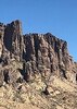
After the summit, we headed down Pumpkin trail. Steep at the top, lots of grass obscuring the trail in places, but the nice views make up for it. All of the aspen are about prime right now, of which there are a lot more of them along this trail than I had realized. Saw one deer or elk off through the trees. There was one patch of deadfall lower down that hides the trail for a short stretch, it’s easy to get over/around, but you do have to search for the cairns. After that, Pumpkin opens up and is an easy walk down to the Connector trail.

East on Connector which is mostly easy walking, although a little vague in places. Quite a few flowers still blooming along the trail. Joe knew most of the varieties, or he’s an expert of making up plausible names on the fly, I sure wouldn’t know the difference. Had lunch not too far before reaching Bull Basin trail.

Headed up Bull Basin, which I really like now that most of the deadfall has been cleared. Excellent and plentiful aspen color along the trail, which was one of the highlights of the day. A summer and fall of traveling, eating, and drinking, combined with elevation caught up to me and I really felt like I was dragging on the uphill, my legs felt like lead. At least I slowed us down through the prettiest part of the trail. Saw a family of superhuman freaks run by, I was both impressed and wanted to knock one over. There’s a little bit of deadfall, mainly near the top, but easy to get over or around. We finally made it to the cabin, chatted with another trio of hikers for a few minutes, then headed down the main trail.

The final four miles were a relief and went by pretty quickly, and I think we finished up around 1630. Overall a great day and hike. Nice trails, good fall color, great views and clouds, and excellent company. The weather was about perfect for an October day—nobody froze, and nobody complained about being hot. Joe, good to see you again and catch up on things. Katie, good to hike with you again, and great job on your biggest hike to date.
foliage observationfoliage observationfoliage observationfoliage observationfoliage observation
Autumn Foliage Observation Moderate
Aspen are mostly around prime
_____________________
Stop crying and just go do the hike.
 
Sep 24 2022
avatar

 Photos 188
 Triplogs 163

43 female
 Joined Oct 26 2011
 Tempe, AZ
Bull Pumpkin Loop, AZ 
Bull Pumpkin Loop, AZ
 
Hiking avatar Sep 24 2022
clairebearTriplogs 163
Hiking11.58 Miles 3,190 AEG
Hiking11.58 Miles
3,190 ft AEG
 no routesno photosets
1st trip
Partners partners
jrc28
Departed Phoenix just after 6am for a mid morning start to a perfect long mountain day. We started from Pumpkin Trailhead and did Connector Trail -> Bull Basin -> Pumpkin

Decent road conditions to trailhead. 193 just off Hwy 180 was pretty rutted with deeeep holes which otheriwse would've been a nice gravel road I spent a few miles dodging these treacherous potholes. Turning onto 171 was a relief and smooth ride to the Pumpkin Trailhead.

The connector trail is a real pumpkin. Following the contours of the mountain and traversing burned up areas and the trail is faint and difficult to follow.( What trail? lol.) We found ourselves off trail a couple times thank you Routescout for keeping us on track. Finally getting onto Bull Basin was a bit of a relief to be in forested areas again. It starts to slowly gain elevation. Beautiful stretch through perfect glowing yellow aspen forest. Then near the top a bit of fallen trees to navigate, but not bad. Finally toping out and enjoying some summit beers and snacks before descending on Pumpkin trail. Very steep descent dropping so much gain in a few short miles. Just a bit more of route finding over fallen trees, but the last couple miles were scenic and very easy to follow. Ok the whole loop was scenic and pretty, but I'm so happily back at the truck for more beers and finding a location to hunker down for the night :)
_____________________
 
Aug 06 2022
avatar

 Guides 93
 Routes 397
 Photos 4,984
 Triplogs 4,124

49 male
 Joined Jun 20 2003
 Tucson, AZ
Kendrick Peak Trail #22Flagstaff, AZ
Flagstaff, AZ
Hiking avatar Aug 06 2022
fricknaleyTriplogs 4,124
Hiking17.20 Miles 4,560 AEG
Hiking17.20 Miles   8 Hrs      2.37 mph
4,560 ft AEG      45 Mns Break12 LBS Pack
 no routes
Partners none no partners
After all these years i finally hiked the Kendrick loop and man it was worth the wait.

ideal, perfect conditions all day with big fluffy clouds and pleasant breezes made for picturesque scenery from start to finish.

i hit the trail about 9:15 after uneventful drive up from oro valley. it has been, i believe, 19 years since i stepped foot on kendrick. dear lord, don't let it be that long again. what a delightful trail all the way up. saw runners and hikers predictably. nice assortment of flowers and colors mixed in with the green.

the upper stretch of bull basin is predictable faint and you have to work around and over downed trees for maybe the first mile or so. then you get into the aspens. open views all along and i really enjoyed this trail more than expected. did not see a soul.

connector is faint but not hard to follow. i rather liked this trail, not really knowing what to expect. hugely open scenery the whole way. again, saw nobody

once hitting pumpkin, i stopped under the little cluster of remaining trees near the junction for a leisurely (for me) lunch with tremendous views. after that it was time for the smack down given by the second ascent of kendrick of the day. moved slow, but steadily and rather enjoyed the grind. i loved the pumpkin trail and all if had to offer.

checked out the summit before heading back down kendrick in absolutely wonderful later afternoon sunshine

this is one of my faves in the state for sure
_____________________
hi
 
Oct 01 2021
avatar

 Routes 154
 Photos 1,505
 Triplogs 266

31 male
 Joined Jun 02 2019
 Phoenix, AZ
Kendrick - Newman Loop, AZ 
Kendrick - Newman Loop, AZ
 
Hiking avatar Oct 01 2021
LJWTriplogs 266
Hiking17.27 Miles 4,812 AEG
Hiking17.27 Miles   7 Hrs   41 Mns   2.55 mph
4,812 ft AEG      54 Mns Break
 
no photosets
Route Scout Route Recorded  on Route Scout | Pop | Map | Popup | MapDEX
Kendrick's east slopes looked yellow a few days before, so I redid this hike from the summer hoping for a yellow tunnel of aspens in Bull Basin. Mountain's 5-7 days away but there was still something. Started at the th instead this time around 6am.

Road walk to the pass between Kendrick and Newman. Should have driven, not as bad as I remembered. Dozen elk and deer in the hills working up to the trail.

Good day for visibility on top. Looks like SF Peaks are just changing on the north side, not much by snowbowl. Quick break and down Bull Basin. Still a few trees down on the upper stretch. Aspen tunnels still largely green. Just turning lower down. That side of the mountain a smattering of reds, yellows, and mostly greens best appreciated from a distance, the trail passed through mostly green.

From BB TH past the tank to 8289, then through the meadows and along the edge of the woods. Peaceful walk, more and more wildlife. Up Pumpkin until it enters the forest and found a better route down this time. Straight down to the roads to Newman.

Started Newman the same but took a detour to avoid the deadfall lattice on the climb up. Enjoyed the meadowy rim views toward Kendrick and The Peaks. More elk and deer, they were pretty much everywhere.

High 20s to low 60s. Didn't see anyone. Snowy, cold forecast this week, hope the leaves hang on for a bit.
foliage observationfoliage observationfoliage observationfoliage observationfoliage observation
Autumn Foliage Observation Light
Kendrick trail a week away, Bull Basin/Pumpkin few days
wildflower observationwildflower observationwildflower observationwildflower observationwildflower observation
Wildflowers Observation Light
  3 archives
Aug 28 2021
avatar

 Routes 5
 Photos 110
 Triplogs 10

78 female
 Joined Jul 28 2011
 Phoenix, AZ
Bull Basin Trail #40 - KendrickFlagstaff, AZ
Flagstaff, AZ
Hiking avatar Aug 28 2021
nancyesanTriplogs 10
Hiking4.00 Miles 2,225 AEG
Hiking4.00 Miles
2,225 ft AEG
 no routesno photosets
1st trip
Linked   none no linked trail guides
Partners none no partners
We just finished hiking the Bull Basin trail and feel that this guide should be updated to show that the trailhead is now at the end of FR90B. It used to be at the end of 90A but the owners of the property there have fenced it off so the trailhead had to be moved. We reached the trailhead by driving north from Flagstaff on 180, turning left on FR191C north of the Kendrick Park meadow area, then west to a sharp right onto FR767, then west to FR760A which becomes FR90 at the Coconino-Kaibab boundary. The Trailhead is at the end of FR90B which splits off to the south from FR90. It is poorly marked coming from the east, but well marked coming from the west. The drive from 180 to the trailhead was 7.4 miles. It took us 65 minutes from 180 to find the trailhead and 40 minutes to get back to 180.

The trail no longer follows any old roads. It starts at the left of the large sign in the parking area. The narrow trail marked with cairns starts in a wooded area left of the sign with little elevation change until you go through the fence and gate into the Kendrick Wilderness area. Most of the trail is not maintained, with fallen trees to climb over or under, brush and tall grass hiding some of the cairns, and loose, slippery rock in steep sections. The 8.4 mile round trip took us about 8 hours, including a 20 min. lunch break at the cabin and many stops for photos. The cabin is locked and it's former contents are stacked outside of it.
_____________________
 
Aug 28 2021
avatar

 Guides 69
 Routes 37
 Photos 3,010
 Triplogs 2,387

55 male
 Joined Oct 24 2010
 Phoenix,Az
Bull Basin Trail #40 - KendrickFlagstaff, AZ
Flagstaff, AZ
Hiking avatar Aug 28 2021
mt98dewTriplogs 2,387
Hiking22.50 Miles 5,200 AEG
Hiking22.50 Miles   9 Hrs      2.50 mph
5,200 ft AEG
 no routesno photosets
1st trip
Linked   none no linked trail guides
Partners none no partners
This has been on my list for awhile and finally made time to check it off. No Garmin still so stats are based off a similar hike I did 4 years ago.

Got to the Kendrick TH around 8am. Much later than my preferred starting time. TH was already packed…about 18 cars. :( Since I didn’t have a device not sure how long it took me to get tot the top, but I made good time, passed 29 hikers (going up or heading down). The trail was in very good shape for the most part. It looked like one section had work done to it as runoff had caused some major erosion. Had the tower to myself; which was nice. Air quality seemed pretty good allowing for some nice views. Forecast had called for rain, but you couldn’t tell it at the time, with blue skies and a few puffs of white clouds.

Next took Pumpkin trail down to its TH. The trail is not nearly as well defined as the Kendrick. Attentiveness is key, especially in the upper stages where the switchback are dominant. Lost the trail briefly going around some deadfall, but otherwise was able to stay on trail. Though I did have to pause a few times to pick it up. Funny, doing this hike 4 years ago, my memory was how “open” (lack of trees) this trail felt. Today I was surprised at d number of forested sections I went through. I guess there is a decent mixture of both - in the upper stages. The lower areas of Pumpkin are very barren, except for a a couple of groves of aspen trees. The first is getting pretty dense, though the trail is obvious as it weaves through. I remember being able to see through it four years ago. Not so today. Still, very little shade is offered. The second grove is nearer the connector trail and is just starting. The other exception to the barrenness were the flowers. Wow!! A rainbow of colors that covered the hills with varying shades of yellow, purples reds, pinks, whites and oranges. A smorgasbord for the eyes. There must have been five different types of yellowish flowers alone (with different petal structures and different shades). Hit Pumpkin TH and turned around. Didn’t care for the climb back up to the connector TH. Very tedious with little pay of.

Connector trail to Bull Basin. There are basically 2 valleys between this point and the Bull Basin trail. I was hoping that the trail would have gotten better with time and that my experience of 4 years ago would help keep me on trail. Pipe dream. Good news: there is now a sign indicating where the connector trail starts and an arrow pointing in which direction to go. But that is it. No trail that I could detect. It definitely would be nice to have a downloaded route for this section - if you have a Garmin. I knew the trail crossed the ridge (leading into the second valley) on the lower shelf below some prominent boulders that dotted the slope, but couldn’t remember how the trail got there. Ended up trouncing a few rainbows on my way to the shelf. Never did come across anything that seemed more than a game trail, but the trail into the second valley was right where I thought it was, with two large cairns indicating the start. Tried to figure out how the trail got to this point….looks like it may have come from higher off the slope, but it was pretty faint and didn’t retake the track I didn’t retrace the track to investigate. The next part of the connector trail is comparatively easy to follow. Just follow the cairns. Large cairns mark the entire route and as I got closer to Bull Basin the trail became more defined. Durning this time the blue skies had turned grey and a light sprinkle had started.

Bull Basin. At the Bull Basin juncture, I first headed east to hit the TH. This section of the trail is pretty nice. Wooded with minimal decline. Probably a little over a mile to hit the TH (guessing). At the TH, across from the parking area (northward direction) there is a locked gated entry with a sign above it that reads “Bull Basin”. Looks old; probably at least my age :lol: Bull Basin is actually a nice trail trail. Easy to follow and the downed trees that had been so prominent in the earlier hike had been minimized. (Still counted 40+ plus trees that I had to negotiate, but most of them were a simple step over). Wish I was a little fresher to enjoy this trail more. Took a handful of breaks to recharge. One was at the saddle that offers great views to the east and a more narrowed view to the north. Great breeze! Love the aspen and the large rocks that make up the mid section of this trail. Glad to see Kendrick juncture….all downhill from there.

Weather was great. Probably in the 70’s for most of the hike. Blue skies to the top of Kendrick, but mainly cloudy skies thereafter with light sprinkles. Amazing how those clouds can develop! Almost all the hikers were on Kendrick. I was startled by three people in hunting fatigues on Pumpkin but that was it. That camouflage really works….I didn’t see those people until they said “hi”to me and I was practically on top of them when they did. Wildlife was surprisingly minimal….what I assume was a grouse, a coyote off in the distance and three horny toads.
_____________________
 
Aug 07 2021
avatar

 Guides 13
 Routes 38
 Photos 1,651
 Triplogs 577

60 male
 Joined Nov 15 2005
 Jackson, CA
Kendrick Peak Trail #22Flagstaff, AZ
Flagstaff, AZ
Hiking avatar Aug 07 2021
toddakTriplogs 577
Hiking17.00 Miles 5,000 AEG
Hiking17.00 Miles   9 Hrs      1.89 mph
5,000 ft AEG
 no routes
Partners none no partners
Kendrick looks to be enjoying a solid monsoon, lots of new lush vegetation to help stabilize the burn zones. The CT, fully refreshed just 2 years ago, is now mostly overgrown. Bull Spring is actually a spring (but I'd still have to be parched to consider drinking it). Several dozen downed trees around the loop, most of them not hard to get around.
wildflower observationwildflower observationwildflower observationwildflower observationwildflower observation
Wildflowers Observation Moderate

water 1 out of 5water 2 out of 5water less than maxwater less than max Bull Spring Quart per minute Quart per minute
about 6" deep in pool, pretty clear, steady outflow
_____________________
 
Jun 16 2021
avatar

 Routes 154
 Photos 1,505
 Triplogs 266

31 male
 Joined Jun 02 2019
 Phoenix, AZ
Kendrick - Newman Loop, AZ 
Kendrick - Newman Loop, AZ
 
Hiking avatar Jun 16 2021
LJWTriplogs 266
Hiking15.88 Miles 4,527 AEG
Hiking15.88 Miles   5 Hrs   33 Mns   3.14 mph
4,527 ft AEG      30 Mns Break
 
no photosets
Route Scout Route Recorded  on Route Scout | Pop | Map | Popup | MapDEX
Third time to Kendrick, third iteration of the loop. This one was my favorite. Goals were to add E Newman, 8289, and Newman Hills, as well as to avoid Crossover and instead walk in the much prettier forests and clearings to the north. Started about a mile and a half up 190 from the Kendrick TH. Parked at the pass between Newman and East Newman. Car passable to the TH, after that high clearance necessary. I think you can circle around on 190 behind Newman with a car, the road was much nicer.

Off trail over really nice terrain 400ft up to E Newman. 400 more feet to meet Kendrick Trail. Took that up the switchbacks to the saddle before going out and back to the summit. Super hazy morning, struggled for breath pushing up Kendrick. The Slate Fire was inactive, but the ghost of the Pinals lingered across the whole state.

Down Bull Basin. Some deadfall in the upper 3rd of a mile. Nice descent, wasn't too warm once out of the shady 8-10ft aspens. Took the trail all the way to the TH. Left the trail and skirted Bull Basin Tank through the woods and up 8289. Smokey air dimished the best views of the day. Left the hill and cut through the forests and clearings north of Crossover. Two dozen white tail deer along the way. Walked the edge of the forest until it more or less bumps into Pumpkin.

Pumpkin was the warmest part of the day, but really not bad. Mid 80s. Not too many wildflowers yet. Ascended until the trail entered the forest and descended off the trail toward Newman Hill. Mostly open pine forest with good footing, though there were some rocky sections.

From 190 near Newman Tank used a couple doubletracks until the second disappeared on the slopes of Newman Hill. Steep climb through a clearing to the meadowy rim of Newman. After that a leisurely walk to the summit. Watched the clouds starting to form over Humphreys and Kendrick and made my way down. Ten minutes down to the car, wouldn't be a bad way up. Nobody all day, but I started at 5:15am.
wildflower observationwildflower observationwildflower observationwildflower observationwildflower observation
Wildflowers Observation Light
KP and BB trails mostly


water 1 out of 5water less than maxwater less than maxwater less than max Bull Spring Dripping Dripping
Brown pools, no flow
  3 archives
Jun 12 2021
avatar

 Guides 110
 Routes 2,246
 Photos 8,982
 Triplogs 2,600

45 female
 Joined Dec 24 2007
 Ahwatukee, AZ
Kendrick double, AZ 
Kendrick double, AZ
 
Hiking avatar Jun 12 2021
LindaAnnTriplogs 2,600
Hiking16.90 Miles 4,812 AEG
Hiking16.90 Miles   9 Hrs   26 Mns   1.97 mph
4,812 ft AEG      51 Mns Break
 
Route Scout Route Recorded  on Route Scout | Pop | Map | Popup | MapDEX
Started at 0615 to temps in the 30’s. Unfortunately, that did not last long and it warmed up quickly. Up Kendrick, taking a snack break at the cabin and another at the lookout. Down Pumpkin, which is as steep as ever, and vague in a few places, especially around the deadfall. Took the Connector over to Bull Basin and up that. Deadfall has been significantly cleared, but there is still some to deal with, maybe 12-18 trees. Nothing terrible, but just enough to be an annoyance. Definitely warm on the way up Bull Basin, but an occasional breeze helped. Easy four miles back down Kendrick to finish out the hike. Didn’t see many people, but did see one trail runner three times, which is also how many times he climbed Kendrick today. Finished just after 1530 with temps in the low 80’s. Not a single cloud in the sky all day, and smoke from the Slate Fire was never an issue.
wildflower observationwildflower observationwildflower observationwildflower observationwildflower observation
Wildflowers Observation Light

water 1 out of 5water less than maxwater less than maxwater less than max Bull Spring Dripping Dripping
Small pool, very light flow. Enough if you were really thirsty.
_____________________
Stop crying and just go do the hike.
 
average hiking speed 2.09 mph
1, 2, 3, 4  Next

WARNING! Hiking and outdoor related sports can be dangerous. Be responsible and prepare for the trip. Study the area you are entering and plan accordingly. Dress for the current and unexpected weather changes. Take plenty of water. Never go alone. Make an itinerary with your plan(s), route(s), destination(s) and expected return time. Give your itinerary to trusted family and/or friends.

helpcommentissue

end of page marker