username
X
password
register
for free!
help
ArticlesGuidesRoutes
 
Photosets
 
 Comments
triplogs   photosets   labels comments more
Humphreys Summit Trail #151 - 172 members in 855 triplogs have rated this an average 4.5 ( 1 to 5 best )
1, 2, 3, 4, 5 ... 43  Next
855 triplogs
login for filter options
Aug 23 2025
avatar

 Routes 2
 Triplogs 2

female
 Joined Jun 25 2025
 Prescott, AZ
B24 crash to humphreys peak, AZ 
B24 crash to humphreys peak, AZ
 
Hiking avatar Aug 23 2025
juliacashmanTriplogs 2
Hiking10.57 Miles 3,482 AEG
Hiking10.57 Miles   6 Hrs   37 Mns   1.96 mph
3,482 ft AEG   1 Hour   14 Mns Break
 
no photosets
1st trip
Partners partners
DominicKrier
Follow Humphreys trail to the last north to south switchback (using maps) then go through the trees on what looks like a very small unmaintained trail. It becomes really steep and we were on all fours like a native bear. It was starting to get dark as we traversed over the ridges to find the crash site. We found the large boulder field and started seeing some debris right as the sun was setting. There is a landing gear sticking straight up probably as tall as a na'vi from the Avatar. Then we voyaged straight up the rockfall - which was small rocks easy to climb - to intercept humphreys trail as the sky darkened and needed flashlights. There are SO many false peaks. Don't be alarmed and try to keep morale up. Peak was so peaceful at night!! There were thunderstorms in the distance and the temps were a little chilly. We followed the official trail on the descent.
 
Jul 29 2025
avatar

 Routes 43
 Photos 4
 Triplogs 43

male
 Joined May 15 2023
 Flagstaff
Humphreys Summit Trail #151Flagstaff, AZ
Flagstaff, AZ
Hiking avatar Jul 29 2025
aarontTriplogs 43
Hiking10.18 Miles 3,425 AEG
Hiking10.18 Miles   7 Hrs   41 Mns   1.54 mph
3,425 ft AEG   1 Hour   5 Mns Break
 
no photosets
Linked   none no linked trail guides
Partners none no partners
Route Scout Route Recorded  on Route Scout | Pop | Map | Popup | MapDEX
 
Jul 24 2025
avatar

 Routes 43
 Photos 4
 Triplogs 43

male
 Joined May 15 2023
 Flagstaff
Humphreys Summit Trail #151Flagstaff, AZ
Flagstaff, AZ
Hiking avatar Jul 24 2025
aarontTriplogs 43
Hiking9.67 Miles 5,162 AEG
Hiking9.67 Miles   7 Hrs   2 Mns   1.63 mph
5,162 ft AEG   1 Hour   5 Mns Break
 
no photosets
Linked   none no linked trail guides
Partners none no partners
Route Scout Route Recorded  on Route Scout | Pop | Map | Popup | MapDEX
No clouds
 
Jun 14 2025
avatar

 Guides 25
 Routes 376
 Photos 5,897
 Triplogs 346

40 male
 Joined Mar 01 2018
 Chandler, AZ
Humphreys - Fremont - B24, AZ 
Humphreys - Fremont - B24, AZ
 
Hiking avatar Jun 14 2025
John10sTriplogs 346
Hiking16.84 Miles 5,654 AEG
Hiking16.84 Miles   7 Hrs   6 Mns   2.62 mph
5,654 ft AEG      40 Mns Break
 
1st trip
Route Scout Route Recorded  on Route Scout | Pop | Map | Popup | MapDEX
For day three, I decided to tolerate the crowds and hike Humphreys, one I'd done a few times before but not in the past 5+ years. I started from Snowbowl ~7:30AM, and it was swarming with people...not surprising, but the sight still had me questioning my decision. The trail was much as I remembered it--lots of rocks and tree roots, and the views don't open up much until clearing the trees near the saddle. There were brief stretches when I had the trail to myself but many more when I was trying to navigate through traffic.

It got up to the peak in about two hours and was pleased that there were only five other people on top when I arrived. Lots of bees, but the weather was much nicer than any of my previous visits, with comfortable temperatures and virtually no wind. I'd planned to hike to Fremont Peak tomorrow as part of a longer loop but decided to head over there now since it was only ~9:30AM and there was plenty of day left. I hung out on the peak for a while, then started down as more and more people arrived. Some places looked like a solid line of hikers coming up as I hiked back to the saddle, then immediate relief once I was on Weatherford.

I passed a few groups as I rounded Agassiz and followed the switchbacks down to Fremont Saddle, where I took a quick break for food/sunscreen. I left the trail there and made the climb up to Peak 11673, which the guide accurately describes as merely a bump on the road to Fremont. The off-trail up to the summit wasn't too bad--some pine branches to push through and a steep and rocky final ascent up to the peak, which has a rock wall windbreak with a wooden post sticking up.

[ youtube video ]

The summit provides a good perspective of the Pipeline burn scar that covers the south/east sides of Fremont, runs along the ridgeline of Doyle and covers much of the area to the south, dividing the mountain into green and brown halves. I took another food break at the top, which the gnats and bees did their best to make it tough to enjoy. The summit register had a lot of familiar HAZ names, and I added mine and then returned to Weatherford Trail via the same route and hiked back to the crowded Humphreys intersection and started down.

Along the way, I left the trail to check out the B-24 crash site. I visited it six years ago but had forgotten just how many large and recognizable airplane parts this site has--much more interesting than the B-17 site on Rees I visited yesterday. This site has become more popular--I saw at least three other people wandering around the scree slope with the wreckage. One of the guys I saw returned to the trail around the same time as me and showed his waiting friends his bloody arm--he'd apparently suffered a fall on the boulders.

The last few miles were easy downhill that practically hiked themselves, and I was back at Snowbowl around 2:30PM. The crowds on Humphreys were predictably annoying but not as bad I expected, and it was nice seeing some new parts of the SF Peaks. After a break in the shade, I decided to hike part of Kachina Trail before driving back to Flagstaff since it was still early.
 
May 29 2025
avatar

 Guides 99
 Routes 1,486
 Photos 16,077
 Triplogs 1,376

male
 Joined Jan 07 2017
 Fountain Hills,
Humphreys Summit Trail #151Flagstaff, AZ
Flagstaff, AZ
Hiking avatar May 29 2025
DixieFlyerTriplogs 1,376
Hiking10.40 Miles 3,342 AEG
Hiking10.40 Miles   8 Hrs   40 Mns   1.30 mph
3,342 ft AEG      39 Mns Break
 
Linked   none no linked trail guides
Partners none no partners
Route Scout Route Recorded  on Route Scout | Pop | Map | Popup | MapDEX
I do not like this trail at all, but I was wanting to get acclimated to some higher elevation hikes so I hiked this one again.

I brought microspikes but did not use them as there was no need to do so.

This was my 34th ascent of Humphreys, but I don't think that I will be up there again this year. At the rate that I am going, it will take 60-70 years to catch @jim

Synopsis
This is a sorry excuse for a hiking trail. It was a nice day for the hike though.
_____________________
Civilization is a nice place to visit but I wouldn't want to live there
 
May 17 2025
avatar

 Guides 3
 Routes 633
 Photos 8,249
 Triplogs 605

54 male
 Joined Apr 13 2011
 Gilbert, AZ
Daily Double, AZ 
Daily Double, AZ
 
Hiking avatar May 17 2025
ddgrunningTriplogs 605
Hiking12.91 Miles 4,246 AEG
Hiking12.91 Miles   9 Hrs   11 Mns   1.63 mph
4,246 ft AEG   1 Hour   15 Mns Break
 
1st trip
Partners none no partners
Route Scout Route Recorded  on Route Scout | Pop | Map | Popup | MapDEX
Agassiz/Humphreys combo. I've summitted Rees, Abineau, Doyle, Fremont, and Humphreys previously, but not Agassiz.

Wanted to do this the prior weekend, but couldn't get the logistics to work out.

Bumped a week and hoped for the best. We left Phoenix around 12:30 am Saturday and were on the trail at 3:15 a.m. Immediately startled a group of around 10 deer grazing on the meadow.

We decided to ditch the lower switchbacks and hike up to the corner of the 4th switchback. As we approached, we overshot and got a little off track, necessitating a little backtracking and bushwhacking.

After connecting with the trail, we made good time. Put the spikes on around 10.8K. Later in the day, we crossed several hikers without spikes, struggling with the climb, but more important, dreading the slip-sliding, butt-scooting descent that would be necessitated by the lack of traction on the way down.

Hoped to watch the sunrise from the saddle, but didn't leave ourselves enough time. That said, as we approached the saddle, the early morning light cast a long shadow of the peaks across the miles below to the west, creating an impressive horizontal outline of Arizona's two 12K peaks.

At the saddle, we headed towards Agassiz. Although most of the snow from the most recent storm had melted, there was still a sliver of deeper "old" snow creating a ribbon along the ridgeline that we followed up to the summit.

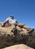
The summit offers great views, but even more than the summit, the ridgeline leading up and back is beautiful, and provides a nice perspective back on the Humphreys ridge.

Back at the saddle, we encountered our first company and we tagged teamed with a couple of other hikers on the way to the Humphreys summit. We shared the summit briefly with two other hikers, but they soon left and we had it to ourselves.

Quite windy on top, but on the bright side--no bugs.

The descent was uneventful. Again, very glad to have our spikes. Crossed paths with many on the ascent.

A very satisfactory day in the AZ mountains.
_____________________
 
May 10 2025
avatar

 Guides 94
 Routes 842
 Photos 22,068
 Triplogs 1,994

52 male
 Joined Sep 18 2002
 Tempe, AZ
Agassiz - Humphreys, AZ 
Agassiz - Humphreys, AZ
 
Hiking avatar May 10 2025
chumleyTriplogs 1,994
Hiking12.04 Miles 4,071 AEG
Hiking12.04 Miles   6 Hrs   57 Mns   2.02 mph
4,071 ft AEG      59 Mns Break
 no routes
1st trip
Partners none no partners
I had looked at the snowpack status for another Agassiz summit a couple of weeks ago, but the bowl was nearly barren -- fully melted out, making the peak off limits.

Last week, however, a round of storms dumped snow on San Francisco Mountain over the course of five days, and it made the timing absolutely perfect to do this one.

Plenty of "old snow" in the trees, and I finally switched to spikes at the 10,2 switchback. The old snow was melted out on the south aspect from 11,1 to 11,3, but the new snow was crunchy enough to necessitate spikes on the ascent. (On the way down it had melted and was just a muddy river in this stretch).

At the saddle I headed uphill on Weatherford. Somebody had put a set of prints up here yesterday, but otherwise virgin snow. The ridgeline cornice was holding strong though I was wary of the stability of the boundary layer between the new snow and the old snow. There were a handful of thin spots that had previously melted out and only the new snow provided cover. These spots will likely melt in the next couple of days, again closing the window for oversnow travel to the Agassiz summit.

After a short break on the Agassiz summit, I headed back down to the saddle where a handful of others were resting. Here I opted to forego my spikes as the south-facing slopes of the 151 provided plenty of options for snowfree steps. After the route turns north though, the rest of the route was covered in new snow. This was fine without spikes as it was soft and hadn't yet been packed down or frozen like the old snow below the treeline.

I enjoyed the solitude of the summit for a few minutes until a friend I ran into earlier arrived and we shared some good stories and entertainment. :) After a few minutes a stereotypical trail runner showed up in short shorts and a t-shirt, wearing a pair of cotton socks on her hands that another hiker had given her after she complained about frostbite. No pack, food, water, jacket or any other appropriate clothing. Nor the sense to maybe turn around when the conditions weren't as expected. Lol. That's not what trail runners do! Did she die? :-k

I opted for spikes again from the saddle down to 10,2. The snow in the trees will last for a few weeks. From 11-1 and up it'll be bare before the end of the week.

Perfect day on the mountain. Glad to bag both of Arizona's 12k peaks on the same trip. I hadn't done the double before.

52 degrees to start, 46 on Agassiz, 39 on Humphreys, 58 to finish. Light breeze on the saddles and summits. Calm otherwise. And that's how I prefer my PHX 100 degree days.
 Named place
 Named place [ checklist ]
[ checklist ]  Agassiz Peak  Humphreys Peak
_____________________
I'm not sure what my spirit animal is, but I'm confident it has rabies.
 
Dec 07 2024
avatar

 Routes 255
 Photos 8
 Triplogs 261

54 male
 Joined Feb 19 2015
 Phoenix
Humphreys Summit Trail #151Flagstaff, AZ
Flagstaff, AZ
Hiking avatar Dec 07 2024
bjonsonTriplogs 261
Hiking12.67 Miles 3,584 AEG
Hiking12.67 Miles   6 Hrs   21 Mns   2.28 mph
3,584 ft AEG      47 Mns Break
 
no photosets
1st trip
Linked   none no linked trail guides
Partners none no partners
Route Scout Route Recorded  on Route Scout | Pop | Map | Popup | MapDEX
_____________________
 
Aug 27 2024
avatar

 Routes 43
 Photos 4
 Triplogs 43

male
 Joined May 15 2023
 Flagstaff
Humphreys Summit Trail #151Flagstaff, AZ
Flagstaff, AZ
Hiking avatar Aug 27 2024
aarontTriplogs 43
Hiking9.75 Miles 3,365 AEG
Hiking9.75 Miles   5 Hrs   13 Mns   2.05 mph
3,365 ft AEG      28 Mns Break
 
no photosets
Linked   none no linked trail guides
Partners none no partners
Route Scout Route Recorded  on Route Scout | Pop | Map | Popup | MapDEX
Beauty Day
 
Jul 06 2024
avatar

 Routes 46
 Photos 253
 Triplogs 47

19 male
 Joined Aug 13 2023
 Phoenix, AZ
Humphreys Summit Trail #151Flagstaff, AZ
Flagstaff, AZ
Hiking avatar Jul 06 2024
diabloTriplogs 47
Hiking11.50 Miles 3,383 AEG
Hiking11.50 Miles   4 Hrs   44 Mns   2.63 mph
3,383 ft AEG      22 Mns Break
 
1st trip
Linked   none no linked trail guides
Partners partners
Laburns
Route Scout Route Recorded  on Route Scout | Pop | Map | Popup | MapDEX
First time up Humphreys living in AZ my whole life. Too crowded for my liking but gorgeous views and great way to get out of the heat.
  1 archive
Jun 29 2024
avatar

 Guides 7
 Routes 79
 Photos 2,440
 Triplogs 652

34 male
 Joined Jan 10 2010
 Pomona, CA
Humphreys Summit Trail #151Flagstaff, AZ
Flagstaff, AZ
Hiking avatar Jun 29 2024
PatrickLTriplogs 652
Hiking10.60 Miles 3,475 AEG
Hiking10.60 Miles   6 Hrs   31 Mns   1.63 mph
3,475 ft AEG23 LBS Pack
 no routes
Linked   none no linked trail guides
Partners none no partners
3am start. Plenty of people already at the trailhead. Started off strong and ran out of gas above 11,400'. Picked up the pace on the last false summit to finish strong. Very cool and windy up top. Good view of the Peaks' shadow as the sun came up. Killer views all around per usual.

Tons of people coming up during the descent. I don't normally hike on weekends but this is the most people I've ever seen on this trail. Back to the car around 9:30am, followed by a mandatory visit to Mama Burger and caffeine before driving back to Phoenix.

Feel like this is the most I've struggled on this one - also had extra weight for training. Maybe a little worn out from Lemmon a couple days ago as well. :sweat:
wildflower observationwildflower observationwildflower observationwildflower observationwildflower observation
Wildflowers Observation Light
Nice colors above treeline, some more isolated blooms along the switchbacks.
_____________________
  1 archive
Jun 22 2024
avatar

 Routes 386
 Photos 49
 Triplogs 792

43 female
 Joined Jun 23 2015
 Phoenix, AZ
Fremont & Doyle PeaksFlagstaff, AZ
Flagstaff, AZ
Hiking avatar Jun 22 2024
emilystardustTriplogs 792
Hiking15.35 Miles 4,428 AEG
Hiking15.35 Miles   9 Hrs   58 Mns   1.73 mph
4,428 ft AEG   1 Hour   7 Mns Break
 no routesno photosets
1st trip
Long day from Humphreys saddle over to Fremont Peak. We summited and then immediately headed back down as a storm was rolling in a couple hours earlier than anticipated. We tried to get below treeline as quickly as possible to take a break but rain/hail made it a little challenging to relax, so ate some snacks quickly and continued out.
_____________________
  1 archive
Jun 11 2024
avatar

 Guides 99
 Routes 1,486
 Photos 16,077
 Triplogs 1,376

male
 Joined Jan 07 2017
 Fountain Hills,
Humphreys Summit Trail #151Flagstaff, AZ
Flagstaff, AZ
Hiking avatar Jun 11 2024
DixieFlyerTriplogs 1,376
Hiking10.33 Miles 3,373 AEG
Hiking10.33 Miles   8 Hrs   4 Mns   1.45 mph
3,373 ft AEG      57 Mns Break
 
Linked   none no linked trail guides
Partners none no partners
Route Scout Route Recorded  on Route Scout | Pop | Map | Popup | MapDEX
I decided to make my 33rd ascent of Humphreys today. I would hike it more, but I do not like the trail at all.

For all intents and purposes Humphreys Summit Trail #151 is in summertime condition.
_____________________
Civilization is a nice place to visit but I wouldn't want to live there
 
Jun 01 2024
avatar

 Routes 13
 Photos 162
 Triplogs 15

male
 Joined Jul 22 2023
 
Humphreys Summit Trail #151Flagstaff, AZ
Flagstaff, AZ
Hiking avatar Jun 01 2024
JamesPTriplogs 15
Hiking13.68 Miles 4,167 AEG
Hiking13.68 Miles   9 Hrs   9 Mns   1.66 mph
4,167 ft AEG      56 Mns Break
 
1st trip
Linked   none no linked trail guides
Partners none no partners
Route Scout Route Recorded  on Route Scout | Pop | Map | Popup | MapDEX
Conditions were nearly perfect except for some route finding and slushy snow. This was the last day for Snowbowl to be running skiers up and down the waste water snow. Kind of a loud place and an obvious slur to the Kachina Gods that reside here. Went at least two miles in total off trail because of the snow making the trail invisible. Did much better following the trail down due to the post hole foot steps and muddy snow. I was surprised how much the elevation affected my body. I definitely did not want to talk much on the final push above the saddle. Took about 2hrs non moving time. Incredible weather, A++. I'm glad to say I've gotten as high as I can in AZ!
 
Oct 14 2023
avatar

 Routes 386
 Photos 49
 Triplogs 792

43 female
 Joined Jun 23 2015
 Phoenix, AZ
Humphreys Summit Trail #151Flagstaff, AZ
Flagstaff, AZ
Hiking avatar Oct 14 2023
emilystardustTriplogs 792
Hiking10.37 Miles 3,363 AEG
Hiking10.37 Miles   6 Hrs   45 Mns   1.77 mph
3,363 ft AEG      54 Mns Break
 
no photosets
Linked   none no linked trail guides
Partners none no partners
Route Scout Route Recorded  on Route Scout | Pop | Map | Popup | MapDEX
Early start from Phoenix, but made it up to the saddle for the eclipse. Aspen Grove area and parking lot area were filled with people when we returned.
_____________________
 
Oct 07 2023
avatar

 Guides 3
 Routes 633
 Photos 8,249
 Triplogs 605

54 male
 Joined Apr 13 2011
 Gilbert, AZ
Humphreys Summit Trail #151Flagstaff, AZ
Flagstaff, AZ
Hiking avatar Oct 07 2023
ddgrunningTriplogs 605
Hiking10.68 Miles 3,362 AEG
Hiking10.68 Miles   6 Hrs   59 Mns   1.72 mph
3,362 ft AEG      46 Mns Break
 
Linked   none no linked trail guides
Partners none no partners
Route Scout Route Recorded  on Route Scout | Pop | Map | Popup | MapDEX
Got an early start on the drive to Flagstaff, and arrived at the TH around 8:30 am. Lots of cars on the parking area, but not full. “Aspen Corner” on the road up was already packed with cars and was even more overflowing when we headed home later that afternoon.

In addition to the fall color hunters, there was an Aravaipa trail running event going on.

The trail was busy, as expected. Weather on the way up was great. The first part of the last mile to the summit above the saddle is always a bit confusing, with a handful of spots where people regularly get pulled into some temporary sucker trails. With as busy a trail as this is, and with so much purported concern about the unique weed that is being protected, I’m surprised they don’t put a few more trail markers in this section.

The fall colors in the inner basin are popping. Still a lot of green at the lower elevations, but it’s coming on strong.

The summit views were nice and with some rolling clouds, it made for nice photos.

The clouds darkened and gathered ranks as we were on our way down, and with about 3/4 mile left, it began to hail/rain lightly. Heard a couple of thunderclaps and were glad we were finishing up.

The rain let up as we finished, but before we got down Snowbowl road, the rain started again, this time more strongly.

I tried hiking in my Tevas. It was great on my toes, but this trail is pretty rocky. Not sure I would have enjoyed another 5-10 miles, but for relatively smooth terrain, I’m a fan.
_____________________
  2 archives
Sep 27 2023
avatar

 Guides 7
 Routes 79
 Photos 2,440
 Triplogs 652

34 male
 Joined Jan 10 2010
 Pomona, CA
Humphreys Summit Trail #151Flagstaff, AZ
Flagstaff, AZ
Hiking avatar Sep 27 2023
PatrickLTriplogs 652
Hiking10.60 Miles 3,470 AEG
Hiking10.60 Miles   5 Hrs   30 Mns   2.05 mph
3,470 ft AEG      20 Mns Break14 LBS Pack
 no routes
Linked   none no linked trail guides
Partners none no partners
First Humphreys visit since 2012. :o Started at 6am and made decent time going up the switchbacks. Around #7 I had difficulty breathing, like an asthma attack - started having that reaction after a case of the Covid this winter. I considered turning around before or at the saddle and thankfully didn't need to. I believe the culprit is all the smoke from the nearby fires. Once above the smoke inversion, I felt better and all that was left to contend with was the altitude.

Chatted with a two guys who summited shortly before me - I heard their victory screech loud and clear. Views north and west were nice, everywhere else was too smoky. Inner Basin is looking pretty yellow, surely another week or two will be even better. Hardly any foliage along #151 but the aspens are getting there - the middle of one grove just west of Humphreys had a slight shade of yellow in the middle. Soon!

Mama Burger is temporarily closed. :lone: My appetite and I found out the hard way.
foliage observationfoliage observationfoliage observationfoliage observationfoliage observation
Autumn Foliage Observation Light
Aspens along the summit trail need to marinate a little longer
_____________________
 
Sep 25 2023
avatar

 Triplogs 71

male
 Joined Jan 23 2025
 Seattle, WA
Humphreys Summit Trail #151Flagstaff, AZ
Flagstaff, AZ
Hiking avatar Sep 25 2023
dhelderTriplogs 71
Hiking10.25 Miles 3,330 AEG
Hiking10.25 Miles
3,330 ft AEG
 no routesno photosets
1st trip
Linked   none no linked trail guides
Partners none no partners
 
Sep 16 2023
avatar

 Guides 4
 Routes 491
 Photos 10,890
 Triplogs 1,257

55 male
 Joined Nov 20 2012
 Phoenix, AZ
Humphreys Summit Trail #151Flagstaff, AZ
Flagstaff, AZ
Hiking avatar Sep 16 2023
BiFrostTriplogs 1,257
Hiking10.25 Miles 3,330 AEG
Hiking10.25 Miles   7 Hrs   19 Mns   1.60 mph
3,330 ft AEG      55 Mns Break
 
no photosets
1st trip
Linked   none no linked trail guides
Partners partners
slowandsteady
Decided to hike Humphreys on a Saturday. Very busy trail as usual even though we started about 630am. Very pleasant temps and reached the summit saddle taking the first break. After the break continued on the to the summit where it seemed more crowded than usual. Lots of bottlenecks both directions so it took some time to make it. Probably 50 or so people on the summit but made the best of it taking a break.

Hiking back down more slow going but just enjoyed the views above tree line. Made it back down by about 3pm and headed into Flag for bite to eat. Next time I'll have to remember to hike the summit off season or weekday if possible.
_____________________
 
Aug 27 2023
avatar

 Guides 110
 Routes 2,248
 Photos 8,982
 Triplogs 2,602

45 female
 Joined Dec 24 2007
 Ahwatukee, AZ
Humphreys Summit Trail #151Flagstaff, AZ
Flagstaff, AZ
Hiking avatar Aug 27 2023
LindaAnnTriplogs 2,602
Hiking10.09 Miles 3,355 AEG
Hiking10.09 Miles   7 Hrs   42 Mns   1.49 mph
3,355 ft AEG      57 Mns Break
 
Linked   none no linked trail guides
Partners none no partners
Route Scout Route Recorded  on Route Scout | Pop | Map | Popup | MapDEX
Humphreys sunrise with Janelle. Her first time hiking Humphreys. Perfect weather, 53 at the start, 39 at the summit with a light breeze, 65 at the finish. As expected, saw nobody else on the way up, and plenty of hikers on the way back down.
wildflower observationwildflower observationwildflower observationwildflower observationwildflower observation
Wildflowers Observation Light
_____________________
Stop crying and just go do the hike.
 
average hiking speed 1.83 mph
1, 2, 3, 4, 5 ... 43  Next

WARNING! Hiking and outdoor related sports can be dangerous. Be responsible and prepare for the trip. Study the area you are entering and plan accordingly. Dress for the current and unexpected weather changes. Take plenty of water. Never go alone. Make an itinerary with your plan(s), route(s), destination(s) and expected return time. Give your itinerary to trusted family and/or friends.

helpcommentissue

end of page marker