|
| | | |
| |
|
| Hiking | 14.70 Miles |
3,377 AEG |
| | Hiking | 14.70 Miles | 7 Hrs 30 Mns | | 1.96 mph |
| 3,377 ft AEG | | | | |
|
|
| |
| Partners |
|
none
[ show ]
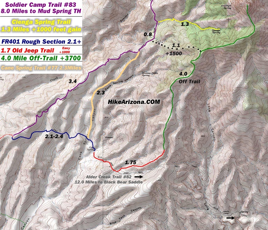
| no partners | | I wanted to look around the southwestern part of the Four Peaks Wilderness. This area is popular with ATVers but there doesn't seem to be a lot of hiking. Best information I found is from some postings by Joe Bartels in 2004 (see this trip, and the speculative Cane Spring to Amethyst Peak trip which contains an intriguing map http://hikearizona.com/t2004/09/29/map02.jpg) and just today I noticed a new posting for an ambitious trip: Cottonwood Camp to Lone Pine via Alder.
Anyway since I just planned to poke around I got a late start and didn't leave my car at Cottonwood Camp until just after noon. I knew I wasn't going to try the rough jeep road (FR401) past Cottonwood Camp - a previous visit showed a very tough step within a half mile or so.
Compared to the trip Joe describes I stayed further south and followed the most likely ATV path just north of main FR401 - it soon hit a fence at the Wilderness boundary which stops the ATVs, but I kept going on an old overgrown road. This was faint in spots but continued, crossed a couple washes, and then climbed the ridge. At the crest it meets up with FR401 - this was ~2.8mi in and here I saw the only sign of the day: I had been walking on Lower Soldier's Trail. Continuing up the road about another mile I ran into two 4-Wheelers (the only people I saw all day) right at the Soldier's Camp Trailhead. This place was unmarked (posts but no signs) but I correctly surmised this was the lower left corner of Joe's aforementioned map. It was pleasant walking on the Soldier's Trail - not too overgrown, plenty of cairns, and it mainly keeps to the ridge top so nice views. I decided I could make a loop of it: continue on Soldier's to the Cane Spring Trail, take that down to the jeep road and then walk this road back to the car.
After about an hour or so I realized I was going to have a daylight problem. I probably should have just turned around but instead I decided to shortcut down hill into Cane Spring drainage just so I could see that place. Turned out to be worth the trip: many pretty waterfalls, but no sign of a trail so it was pretty slow going. By the time I hit the road it was 5PM. I think the intersection is just above the Cane Spring Trailhead (which I didn't see). The road may be tough to drive but walking it is no picnic either: I think it was 6.5 miles back to Cottonwood Camp and a lot of up and down. Pitch black - thank goodness for long range keyless remotes.
My conclusion: if you want access to the upper reaches of Four Peaks from the southwest you need to drive that road. On the other hand there's some nice hiking in the area even if you don't. |
| _____________________
| | |
|
|
|
 Route Editor


